
お気に入りのオリジナル写真を加工して作る、高画質のアハ体験ムービー。フェーズ32は、前回と同じく2014年から2018年、広島の呉から今治までの「とびしま海道」と、今治から尾道までの「しまなみ海道」を、自転車道で走った時の写真だ。
High quality AHA experience movies made by processing your favorite original photos. Phase 32 is the same as the previous one, from 2014 to 2018, when we rode the "Tobishima Kaido" from Kure to Imabari in Hiroshima and the "Shimanami Kaido" from Imabari to Onomichi by bicycle path.
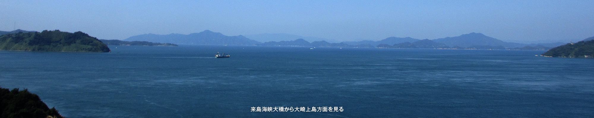
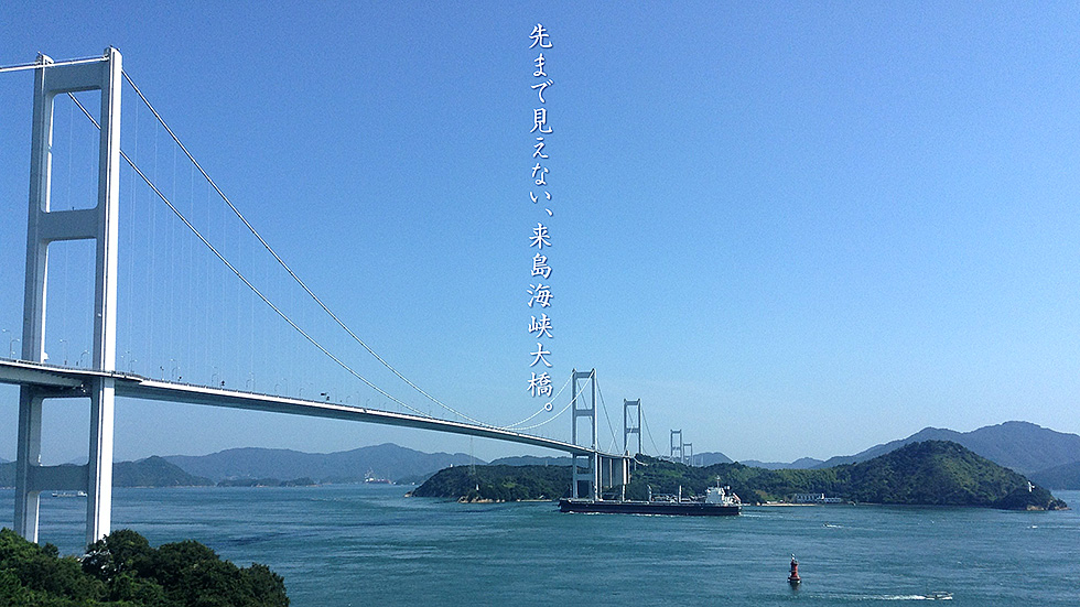
今治側の休憩施設、サンライズ糸山から見た、来島海峡大橋。三つの橋が繋がっていて、自転車と徒歩で、海面の約65メートル上空から、約4キロに渡る空中浮遊が楽しめる。すぐ下を大型船が通り、遠くの島々まで見渡せる圧巻の景色は、誰もが感嘆の声を上げる。橋が最初に渡る島が馬島、繋がって見える津島、橋の下左側に見えている大きな島は大三島だ。
最後に橋の下を通って、今治港に向かう船から撮った写真も載せた。大型船が間断なく通っているのが判る。
The Kurushima Kaikyo Bridge seen from Sunrise Itoyama, a rest facility on the Imabari side. The three bridges are connected, and cyclists and pedestrians can enjoy a four-kilometer aerial flight from about 65 meters above the surface of the sea. Large ships pass just below, and the view of the islands in the distance is breathtaking, leaving everyone in awe. The first island the bridge crosses is Umajima island, then Tsushima island, which appears to be connected to the bridge, and the large island on the left under the bridge is Omishima island.
Finally, I also included a photo taken from a ship passing under the bridge on its way to Imabari Port. You can see large ships passing under the bridge without interruption.
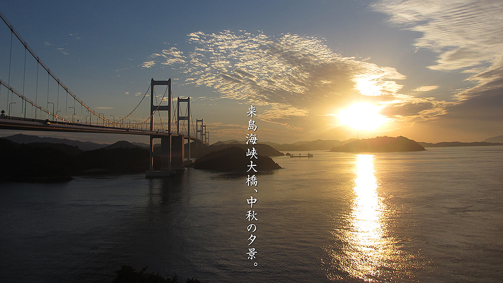
大島側から来島海峡大橋に登っていく時に見える夕焼け。小島と呼ばれる決して小さくない島に、今夕日が沈んでいく。その先は四国本土で波方町だ。この季節だけ、橋に夕日が反射してとても美しい。最後に、ここから画面を右に振って「とびしま海道」の大崎上島、大崎下島が、遠くに見渡せる写真と大島吉見町の海岸から橋を撮った写真も載せておく。
The sunset seen when climbing the Kurushima Kaikyo Bridge from the Oshima side. The sun is setting on a not-so-small island called Kojima. The destination is Namikata Town on the mainland of Shikoku. Only during this season, the reflection of the setting sun on the bridge is very beautiful. Lastly, I have included a photo of Osaki-kamijima and Osaki-shimojima of the "Tobishima Kaido" from here to the right, as well as a photo of the bridge from the beach in Yoshimi Town, Oshima Island.
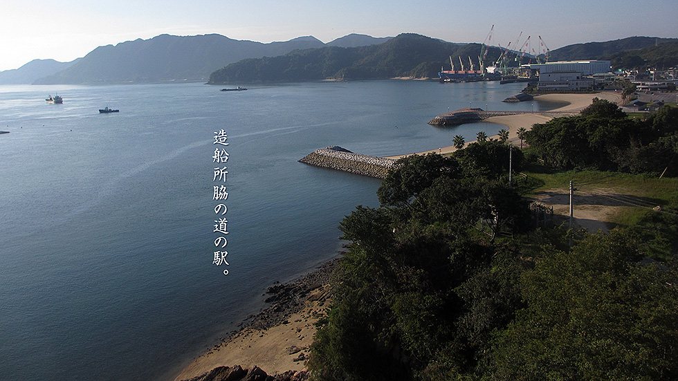
瀬戸内海には、実に造船所が多い。そんな造船所のすぐ脇にあるのが、道の駅「伯方S・Cパーク」だ。しまなみ海道を自転車で旅する人たちは、ほぼこの道の駅に立ち寄り「伯方の塩ソフト」をかぶりつく。この道の駅には、作られたものではあるが、実に美しいアーチ型の砂浜があり、そこで海に見ながらいただくソフトクリームは実においしい。
There are indeed many shipyards in the Seto Inland Sea. The roadside station "Hakata S.C. Park" is located right next to such a shipyard. People traveling along the Shimanami Kaido by bicycle almost always stop at this roadside station to enjoy a bowl of "Hakata no Shio-Soft" (Hakata salt soft serve ice cream). The roadside station has a beautiful arch-shaped sandy beach, which is a newly built structure, and the soft-serve ice cream served there while looking out at the sea is truly delicious.
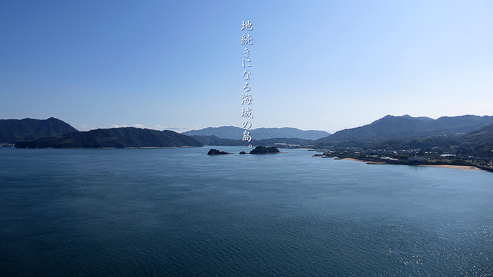
しまなみ海道で一番美しい橋、生口島と大三島を結ぶ多々羅大橋の上から南を見た写真。真ん中に見えるのが古城島で、年に数回地続きになるらしい。ここは、中世に甘崎城と呼ばれる海城で、村上水軍が海域の通行税を徴収する拠点にもなっていた。
その後にある島が伯方島で、その後が大島、その左端には四国の最高峰、石鎚山もわずかに見えている。
最後にその石鎚山をアップで捉えた写真と、逆側から見た撮影地点の多々羅大橋を載せておく。橋の向こう側の島は、右が生口島、正面が高根島。
This is a photo looking south from the top of Tatara Ohashi Bridge, the most beautiful bridge on the Shimanami Kaido, connecting Ikuchijima and Omishima. The island in the center is Kojo Island, which is said to be connected to the land several times a year. This was a medieval sea castle called Amasaki Castle, which was also a base for the Murakami Suigun to collect tolls in the sea area.
The island after it is Hakatajima, followed by Oshima, and at the left end of the island is Shikoku's highest peak, Ishizuchi, which is also slightly visible.
Ishizuchi and the Tatara Bridge from the opposite side of the island. The islands on the other side of the bridge are Ikuchijima on the right and Takanejima in front.
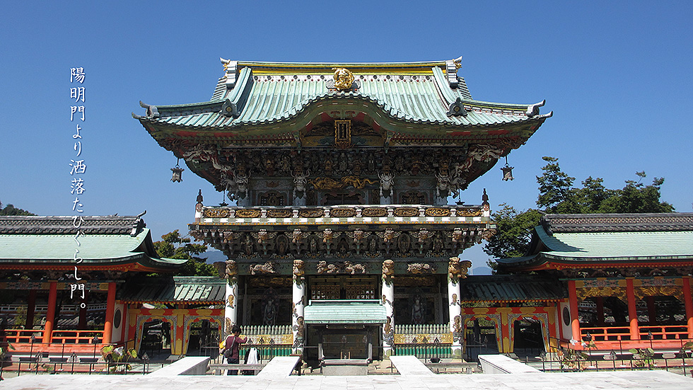
日本各地の著名な神社を模して、1936年に建築者の母のために創建された耕三寺。生口島の瀬戸田にあり、その存在は、ただ凄いの一言。写真は、日光東照宮の陽明門の図面を取り寄せて造られた、孝養門。現在、修復を終えた本家、日光の陽明門より、権力の象徴である金や派手な彩色がない分、とても美しい。
Modeled after prominent shrines throughout Japan, Kosanji Temple was built in 1936 for the architect's mother. Located in Setoda on Ikuchishima Island, its presence is simply awesome. The photo shows the Koyomon Gate, which was built from drawings of the Yomeimon Gate at Nikko Toshogu Shrine. It is more beautiful than the original Yomeimon of Nikko, which has now undergone restoration, because it lacks the gold and gaudy colors that are symbols of power.
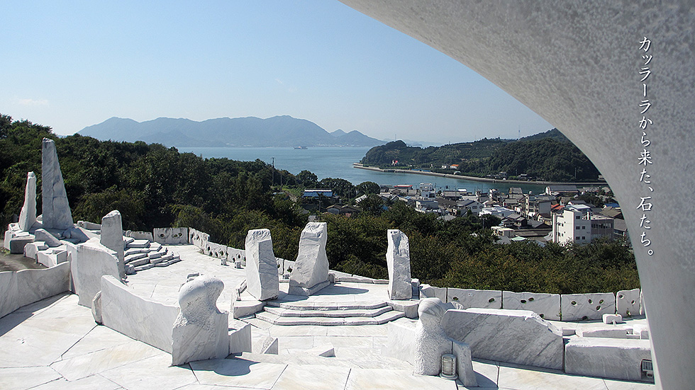
生口島瀬戸田、耕三寺の裏山は、大理石を使った庭園になっている。イタリア・カッラーラで採掘された大理石に彫刻を施し、日本まで運んできたという。
見下ろせば、瀬戸田の街、港、海が見えて、風が通り抜ける。それを活かすように大理石がバランスよく配置されて調和の取れた、とても気持ちのいい美術庭園になっている。頂上には、合掌をモチーフにしたオブジェがあり、青空にとても映えている。
The hill behind Kosanji Temple in Setoda, Ikuchishima is a marble garden. The marble was mined in Carrara, Italy, carved, and brought to Japan.
Looking down, one can see the city of Setoda, the port, and the sea, with the wind blowing through. The marble is balanced and harmoniously arranged to take advantage of this, creating a very pleasant art garden. At the top of the garden, there is an objet d'art in the motif of a gassho (join hands), which looks very beautiful against the blue sky.
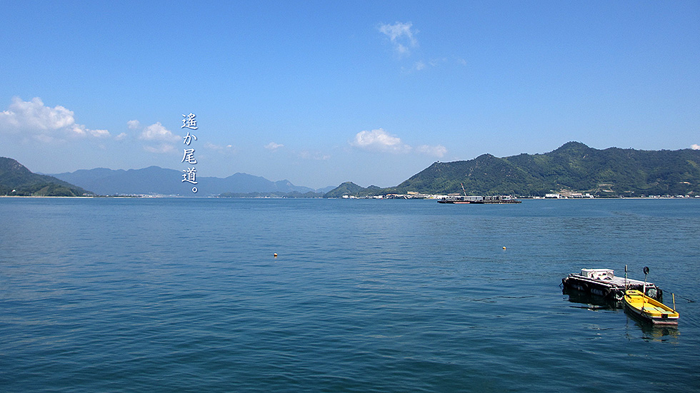
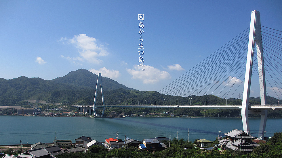
右が因島、左が佐木島、その向こうが細島を経て中国山地に突き当たり、右に少し行くと、細い水道となって尾道に至る。因島の白い建物のあたりは、健康食品で有名な万田酵素の発酵パークで、工場見学もできるようになっている。
On the right is Innoshima Island, on the left is Sakijima Island, and beyond that, via Hososhima Island, we come to the Chugoku Mountains, and a short distance to the right is a narrow waterway that leads to Onomichi. The white building on Innoshima Island is a fermentation park of Manda Enzyme, famous for its health food products, where visitors can tour the factory.
因島から生口橋を渡る際に、自転車とバイクは、左右に分かれて渡る。入口から、民家を横切り、柑橘類に囲まれた上り坂を行くと頂上近くに展望広場が現れる。そこから撮った写真なのだが、地元のCMやポスターなどの画像にも、ここからの景色がたくさん使われているらしい。
生口橋を因島北側のコンビニから、低いアングルで撮った写真も載せておく。橋の向こう側に見えるのは、常石造船因島工場だ。
When crossing the Ikuchi Bridge from Innoshima Island, bicycles and motorcycles cross the bridge separately on the left and right. From the entrance, cross the houses and go uphill surrounded by citrus fruits, and you will see a viewing area near the top. This photo was taken from there, and the view from here has been used in many local commercials and posters.
I have also included a photo of the Ikuchi Bridge taken from a low angle from a convenience store on the north side of Innoshima Island. The Tsuneishi Shipbuilding Innoshima factory can be seen on the other side of the bridge.
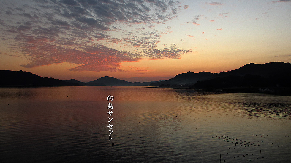
しまなみ海道ではないのだが、福山から尾道市に入ったあたりに、マリーナ尾道という、たくさんのクルーザが並んでいる場所がある。そこからは、向島に沈む尾道方面の綺麗な夕日が堪能できる。スパを備えた高級ホテルも併設されているのだが、ビンボーニンには、お薦めできない。少し南に下ると常石造船の工場が林立している。そちらの方が見ていて楽しいかもしれない。
Although not on the Shimanami Kaido, there is a place called Marina Onomichi, where many cruisers are lined up in a row, around the entrance of Onomichi City from Fukuyama. From there, you can enjoy the beautiful sunset over Mukaishima Island in the direction of Onomichi. There is also a luxury hotel with a spa, but it is not recommended for the average person. A little further south is a forest of Tsuneishi Shipbuilding factories. It might be more fun to see them.
特に潮の干満差の激しい瀬戸内海において、一番栄えた潮待ち港が鞆だ。交通量の多い瀬戸内海の中心に位置し、天然の良港を持っていたためだった。今でも観光地ではない街として機能しており、住民は年に一回のお祭りを楽しみにしている。大規模な再開発をある程度回避し、狭いながらも路地や昔の佇まいを残し、そのまま現在に繋がる街の景観は、タイムスリップをしたような感覚だ。どこか懐かしくほっとする街を、漁船とシンボルとなる常夜灯に見てみた。
最後に、常夜灯側から見た、いかにも漁港らしい、夕日の当たる鞆の街の写真も入れておく。
Tomo is the most prosperous tidal port in the Seto Inland Sea, where the tidal range is particularly large. This was because it was located in the center of the Seto Inland Sea, where there is heavy traffic, and had a good natural harbor. It still functions as a non-touristy town, and residents look forward to the annual festival. The townscape, which has avoided large-scale redevelopment to some extent, and retains its narrow alleys and old appearance, leading directly to the present, is like stepping back in time. I saw a nostalgic and relaxing town with its fishing boats and symbolic everlasting lights.
Lastly, I have included a photo of Tomo Town seen from the side of the nightlight, which is a typical fishing port and is illuminated by the setting sun.

