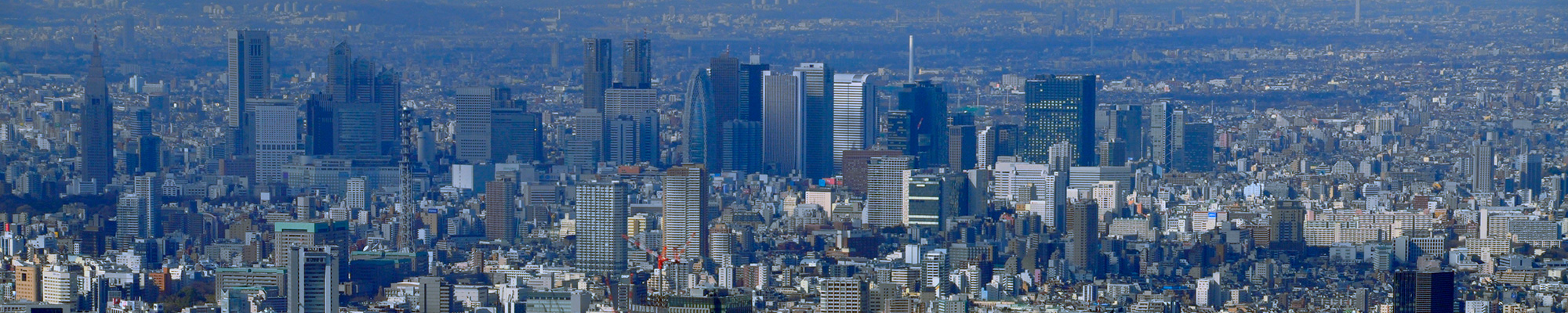

I actually visited one of my favorite places, One Hundred Famous Views of Edo, drawn by Hiroshige Ando, and what the scene is like now.
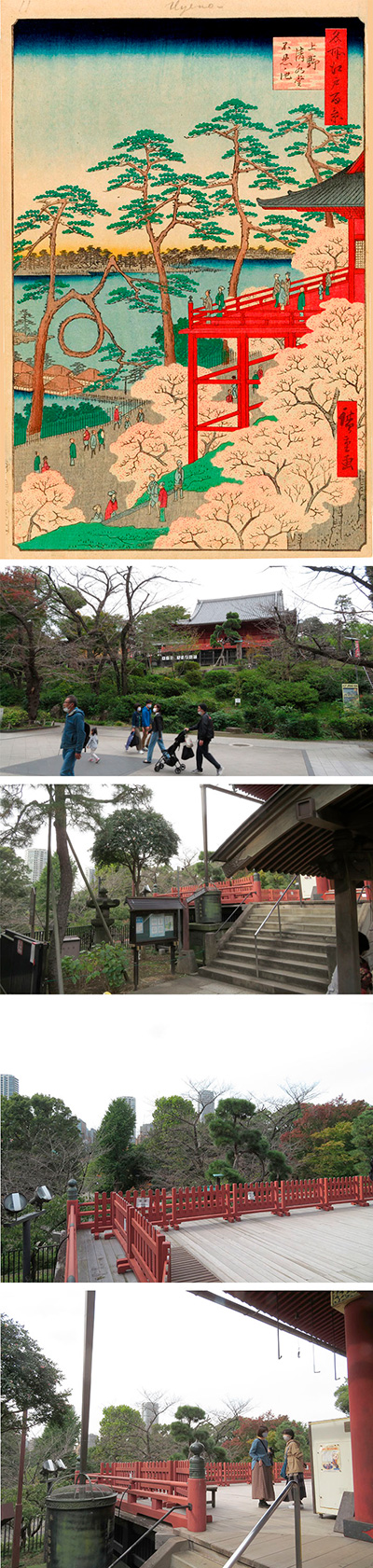
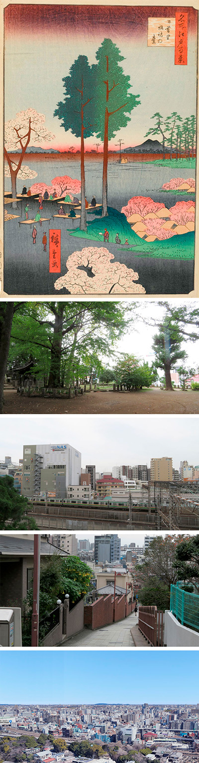
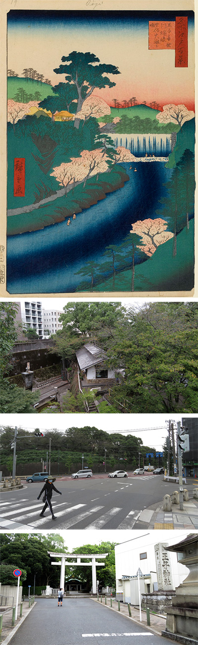
011 Ueno Kiyomizu-do Shinobazu Pond has a composition that overlooks Shinobazu Pond, the approach to Benten-do, and the Hongo Plateau in the back from the side of Kiyomizu-do in the still-existing Ueno Park.
First, let's check the location from the old map. I put a red gradation in the place to be the viewpoint. The light blue line that crosses left and right at the bottom is the Kanda River. The thick light blue that runs diagonally to the right is the Sumida River. I overlaid a modern map on this.
Let's enlarge the picture and see it from above.
It is said that the Kiyomizu-do in this painting was moved to its current location during the Genroku era. It seems that there was not much damage in the big earthquake of Ansei that occurred just before this picture was drawn. Furthermore, it has miraculously escaped from the Ueno War of the Meiji Restoration, which almost ashed Kaneiji Temple, the Great Kanto Earthquake, and the war of World War II. Today, it is an important cultural property of the country.
Originally, from the city planning of Edo, this neighborhood was made by Tenkai Sojo, the founder of Kaneiji Temple, the family temple of the Tokugawa family, imitating Kyoto. It is said that Shinobazu Pond was nearly twice as large as it is now, and this is Lake Biwa. Nakashima, where Ueno Benten-do is currently located, seems to have been coming and going by boat when it was first built, and was created with the image of Chikubu Island. This Kiyomizu-do is made with the motif of Kiyomizu-dera in Higashiyama, Kyoto. It is said that Kaneiji Temple is also known as "Mt. Hiei" in the sense of "Mt. Hiei in the east", following Mt. Hiei, which protects the demon gate (northeast) of the capital of Kyoto.
As for the cherry blossoms in the picture, it is said that the Tenkai Sojo planted cherry blossoms at different times in a planned manner in order to make them famous for cherry blossoms, just like Yamato - Mt. Yoshino. Therefore, from the end of February to the middle of March of the lunar calendar, I enjoyed the cherry blossoms all the time. Furthermore, only during the cherry blossom season, the black gate at the entrance on the Hirokoji side was opened to allow the common people of Edo to enter the mountain. However, the rules of Kaneiji Temple are strict, and it is forbidden to eat fish or dance with shamisen or drums, and it seems that they were kicked out at 6 pm. Compared to the current Ueno Park, it's a big difference.
Let's take a closer look at the main parts of the picture.
This picture itself is a very deformed picture. First of all, the height difference of the stage of Kiyomizu-do is drawn more than double the actual number, and the number of cherry blossoms is also drawn considerably more than the actual number. Furthermore, the stone steps in front of the approach to Benten-do leading to Nakashima collapsed due to the great earthquake of Ansei the previous year, and the teahouse was also burned down. Hiroshige seems to have assembled the composition well and concealed the hidden parts.
In fact, this is a picture of Kiyomizu-do looking up from below. The moon pine has been restored in recent years.
I also went to a place where I could actually see it. You can see that the height difference and the scenery are quite different. Even so, I tried to forcefully insert a picture that seems to be a picture into the picture.
As usual, many Edo people are depicted in this picture. Looking at it in this way, you can see that the genius painter Hiroshige was drawing a picture that would entertain the viewer from the perspective of the common people.
 I actually visited one of my favorite places, One Hundred Famous Views of Edo, drawn by Hiroshige Ando, and what the scene is like now.
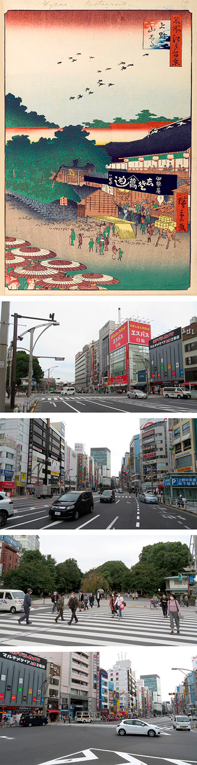
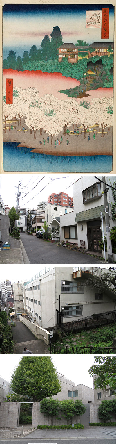
It seems that 012 Ueno Yamashita that you could see the direction of Ueno Station from the traffic light of Ueno 4-chome and the street opposite McDonald's.
Let's divide the picture into two and look at it from above.
You can tell that this picture is a spring picture by the swallows flying in the sky.
Below that, you can see the torii gate of Gojo Tenjin. This Tenjin-sama enshrines a medicinal ancestor, and after several relocations, it is now in Ueno Park. The historic site of Gojo Tenjin is still left at the entrance to Ameyayokocho. To the right is "Shisomeshi Iseya", and a banquet is now being held on the second floor. Seems to be enjoying.
At the bottom of the picture, the first floor of Iseya is even more crowded, with large fish that are probably Thai lined up, fish that look like flatfish are hung, and the waiter carries the famous "Shisomeshi" in a red container. I'm out. People go in and out of the alley on the left side, but after that, it continued to the fire protection area in front of Ueno Station via Gojo Tenjin. Therefore, it is said that the area around this area was called "Ueno Yamashita" for Uenoyama.
In front of the store, a bad horse called Honma is about to enter a crowded alley with his luggage on his back. At that time, the horse was carrying up to 135 kg of luggage.
The townspeople on the street may have just returned from cherry blossom viewing. The owner and wife of the shop are talking with an apprentice-style person on the street. After that, in the reed teahouse, several tradesmen who may already be drunk are drawn. The depiction of humans around here seems to be Hiroshige.
At the bottom left, the group of snake-eye umbrellas are probably the people who are about to go to see the cherry blossoms in the mountains of Ueno. However, even though the clothes are like the wife of Edo Castle, the balance of the snake-eye umbrella used only by geisha is strange. Furthermore, because the size balance with the townspeople on the street is also strange, it is said by researchers that this painting was drawn by Hiroshige II. In fact, the publication date of this painting is after the death of the first Hiroshige.
Next, let's check the location from the old map. I put a red gradation in the place to be the viewpoint. The light blue line that crosses left and right at the bottom is the Kanda River. The thick light blue that runs diagonally vertically to the right is the Sumida River. I overlaid a modern map on this. From around the traffic light at Ueno 4-chome, you can see that you are almost looking toward Ueno Station.
I expanded the old map further. The small river that flows out of Shinobazu Pond is the Oshigawa River, which has three bridges, and the area from this perspective was called Mihashi (three bridges).
To make it easier to understand, I have roughly included the facilities that are the current guidelines. I also put a modern map on it.
Also, although the north is to the right, the map of 1845 had a clear positional relationship at that time and was easy to understand, so I also added a red gradation of the viewpoint to this. I added Matsuzakaya and Ueno station, which are modern points. Currently, the position of the Ueno Park police box is around the beginning of the stone wall in the painting, so you can see that Hiroshige drew the area around the entrance of the alley.
Well, this photo is what I actually went to this place. I presume that the viewpoint is not almost above the sky. The road is much wider and there are many large buildings.
Looking back, you will see the direction of Kanda. It is the current appearance of the fire protection area called "Shitaya Hirokoji" drawn on the map.
This is a picture of the current state of going up the road on the left side of the stone wall in the picture. The place where the black gate of Kaneiji Temple used to be, and now it is the entrance to Ueno Park, and below this is Keisei Ueno Station.
This is a picture of the Hirokoji area, which is the viewpoint of the picture, from the police box side. The actual point of view seems to be around the pedestrian crossing in the photo. At that time, the Oshigawa River flowed from Shinobazu Pond on the right side to the left side, and three bridges were built, which was called Mihashi. It seems that the bridge in the middle was supposed to be crossed only by the shogun and the envoy. Even in the Meiji era, this "Mihashi" remained as a place name, and the sweets shop that was founded at that time and was named "Mihashi" still remains. That is the photo fold side. It is a popular shop that is cheap and delicious.
I tried to fit modern photographs into Hiroshige's paintings. The height of the viewpoint is different, but you can see that the road is ridiculously wide. Approximately 20 years after Hiroshige drew this painting, Ueno Station opened using the fire-fighting area of "Ueno Yamashita" and the ruins of the Kaneiji Temple, which is a large gateway to the north of Tokyo. It has evolved.
I actually visited one of my favorite places, One Hundred Famous Views of Edo, drawn by Hiroshige Ando, and what the scene is like now.
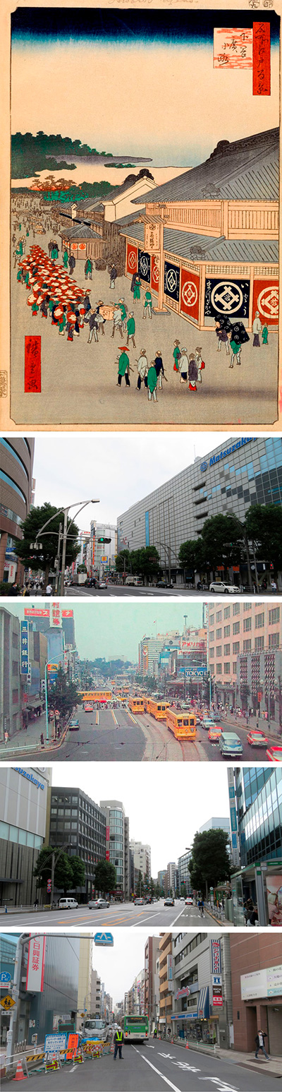
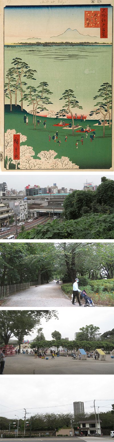
013 Shitaya Hirokoji is a view of Matsuzakaya from around the current intersection of Ueno Hirokoji in the direction of Kanda. It's about 200m Ueno Yamashita last time.
Let's divide the picture into two and take a closer look from above.
First of all, the thick forest above is the forest of Kaneiji Temple. From there, I went down Kuromon (black gate), which is the entrance to Kaneiji Temple, and it was Uenoyama, which I introduced last time. In this painting, the stone wall (Hakamagoshi) surrounding Kuromon (black gate) , the Shinobu River flowing under it, the three bridges over it, and the Mihashi are also depicted.
This Shitaya Hirokoji was built in 1657 by widening the road to prevent fire and burning from the lessons of the Great Fire of Meireki, but since the Genroku era (around 1688), it is a specialty on both sides of the road. It was lined with shops selling specialty products and had a function as a major entertainment area. The bustle is depicted in this picture as well.
Around the center of the picture, you can see a white storehouse called Tanagura. This tells how prosperous Ito Matsuzakaya, which has a store on the main street.
If you look at the bottom of the picture, you will see a building with a red circle design on the road side of the storehouse. This is a mobile hairdresser, the current barber's stall. However, looking at the map at that time, this place was the place where the Bansho (current police box) was located, so it seems that it was rewritten with some intention.
It seems that the group walking with the matching umbrellas of red and white design will go to see the cherry blossoms in the Kiyomoto training company. At that time, it seems that it was popular for the disciples to go out to see the cherry blossoms as a group, led by the masters of the lessons such as Koto, Shamisen, Joruri, and Tokiwazu.
Around the bottom of the center, a group of samurai are drawn, perhaps heading for cherry blossom viewing. What's interesting is that some of the people in this group are wearing trousers of the time, called Danbukuro. Is Edo symbolically depicting the time when samurai wear trousers at the end of the period?
On the right side, Ito Matsuzakaya, the main part of this painting, is depicted with a clerk carrying luggage. Matsuzakaya, which still exists, is a store that was created by Itoya, a garment dealer in Nagoya, who acquired Ueno Matsuzakaya in 1768. At that time, it seems that the name of Matsuzakaya, which was already famous in Edo, was left as it was and became Ito Matsuzakaya. The mark, which has the character of wisteria written in the circle on the girder, still inherits its shape and color.
By the way, the reprint of this picture (renewal), that is, the issue date is the third year of Ansei, September 1856. However, the Matsuzakaya building collapsed in the previous year's Ansei earthquake and was destroyed by fire. The store itself started temporary business in Nihonbashihoncho 2-chome in December, but at the same time, Owari called the 11th Takenaka Toemon to Edo and asked him to rebuild Matsuzakaya in the same place. The general contractor that this descendant Takenaka Toemon opened in Kobe is the current Takenaka Corporation.
By the way, the publication date of this picture is September 1856, the third year of Ansei. However, the Matsuzakaya building collapsed in the previous year's Ansei earthquake and was destroyed by fire. The store itself was temporarily open in Nihonbashihoncho 2-chome from December, but at the same time, the 11th Takenaka Toemon was called to Edo from Nagoya and asked to rebuild Matsuzakaya at the same location. The general contractor opened in Kobe by the 14th Takenaka Toemon of this descendant is the current Takenaka Corporation.
It was three days since September 28, when this picture was published, that Matsuzakaya began to open and sell the new store, which was completed after spending more than $ 15 million. Then, it is said that this picture was also drawn for the main purpose of the advertisement for the renewal sale of Matsuzakaya.
In fact, there is a record that sales over the last three days have reached $ 3 million. At that time, the Uogashi of Nihonbashi, the Kabuki Sanza in Saruwakacho, and the Shin-Yoshiwara behind Kannon were touted as Edo sights of $ 1 million a day, but this renewal sale made this Matsuzakaya achieve it. I did. In the shadow, some researchers suspect that this picture was used as a substitute for an advertising leaflet called a Hikifuda.
Next, let's check the location from the old map. I put a red gradation in the place to be the viewpoint. The light blue line that crosses left and right at the bottom is the Kanda River. The thick light blue that runs diagonally vertically to the right is the Sumida River. I overlaid a modern map on this. From around Kanda at the Ueno Hirokoji intersection, you can see that you are almost looking toward Ueno Station.
Also, although the north is to the right, the map at the time of Tenpo had a clear positional relationship at that time and was easy to understand, so I also added a red gradation of the viewpoint to this. I added Matsuzakaya and Ueno station, which are modern points. Currently, the position of the Ueno Park police box is around the stone wall drawn in the back of the picture.
I actually asked what happened to this point now. Shitaya Hirokoji, which was a fire protection area, has more than doubled the width of the road and is called Chuo-dori. The red light you can see is the intersection of Ueno Hirokoji, and below this, you will find Tokyo Metro Ueno Hirokoji Station, Toei Subway Oedo Line, and Ueno Okachimachi Station. Ueno Matsuzakaya on the right side was renewed in November 2017 and has become a larger building.
This is a picture of the Kanda side, just behind the viewpoint. It's the place where the road was cranked on the old map. After this, head toward Kanda via Akihabara Electric Town.
This is a photograph of the left side and the west direction from the viewpoint. After this, you will pass the north side of Kuromon Elementary School and reach Otokozaka at Yushima Tenjin Shrine.
Since the viewpoint is low in the current photo, I adjusted the height of the viewpoint on Google and tried to fit Hiroshige's picture into it.
When I searched the internet, I found a picture of the local area in 1966. Two years after the Tokyo Olympics. The viewpoint is almost the same as the height of the picture.
I put Hiroshige's picture on it. It's a bit nostalgic, but it's 110 years after Hiroshige's drawing.
Furthermore, although the height of the viewpoint is different, I tried to fit the current city 164 years after Hiroshige.
At that time, Hiroshige could not have imagined that the city would face a new challenge of the coronavirus.
 I actually visited one of my favorite places, One Hundred Famous Views of Edo, drawn by Hiroshige Ando, and what the scene is like now.
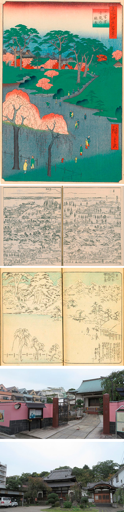
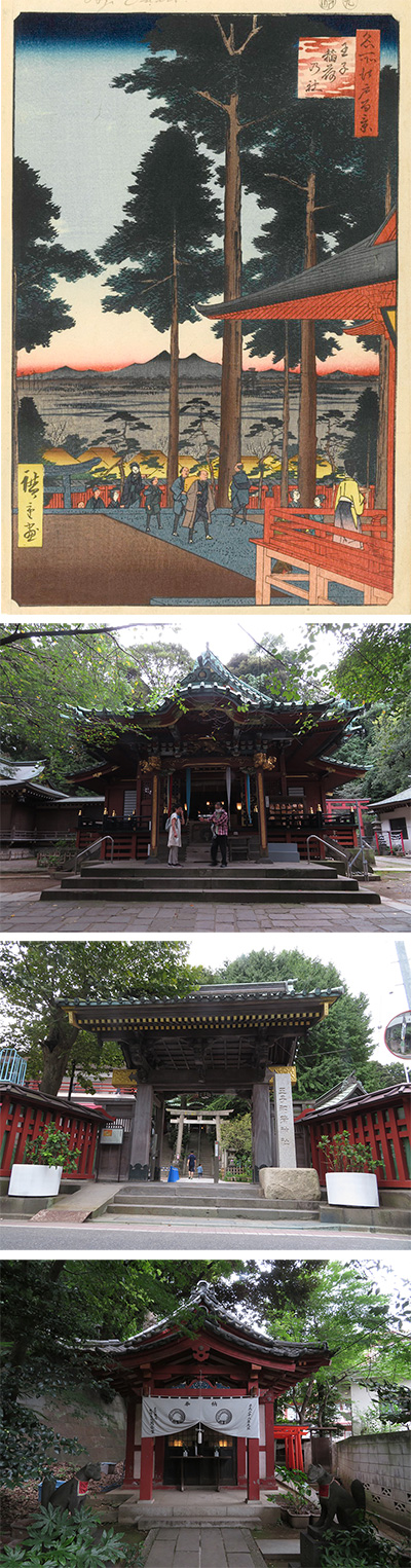
014 Temple Gardens at Nippori somewhere on the south side of the current Nishi-Nippori Station. A Rinsen(forest spring) is a garden created by arranging trees, ponds, and running water.
This time, please start with a map that shows the height difference. The yellow area is the plateau, and the green and blue areas are low. The location of the temple that Hiroshige drew this time is like the garden of a temple on Mt. Dokanyama. Dokanyama is in the middle of the plateau that leads from Kaneiji Ueno to Oji Asukayama via Tabata. The large yellow triangle on the map is the location.
In the olden days, it was written as a new moat and was written as Nippori, but since the time of Kan'en (1748-51), azaleas have been planted, and the area has become a famous place where the beautiful garden of the temple continues. The cherry blossoms in spring and the autumn leaves are beautiful, and I forget about the sunset, so it is also called "Higurashi no Sato" and I wrote it as Nippori. The range extended from the back gate of Yanaka's Kannoji Temple (currently Tennoji Temple) toward Dokanyama, with temples scattered on the west plateau and rural areas in the eastern lowlands.
In the middle of the Edo period, Dokanyama and Higurashi no Sato had a good view, many flowers of the four seasons, abundant medicinal herbs, and many collectors and tourists visited.
Therefore, each of the scattered temples competed to maintain the garden. Jokoji Temple in Yukimi Temple, Hongyoji Temple in Tsukimi Temple, Myoryuji Temple, Shuseiin Temple, Seiunji Temple in Hanami Temple, Hanami in Suwa-no-dai, Hearing insects in Mt. Dokanyama, etc. It was a major holiday resort.
So, where is the garden of this painting? So let's go back to Hiroshige's painting and take a closer look. First of all, what seems to be the main hall of the temple is drawn at the top of the picture. On the slope, there are wild cherry blossoms, flat land with tourists drawn, and weeping cherry blossoms in the foreground.
This means that it is one of the famous Hanami temples, namely Myoryuji, Shuseiin, or Seiunji Temple.
If you take a closer look, there are some hints. On the right side of the picture, it is a garden tree cut in the shape of a ship. When I searched for more materials, I found a similar tree in the Nippori map of the Edo tourist attraction magazine Edo Meishozue, which was drawn around the time of Tenpo. This was published in 1834 by Settan Hasegawa with a bird's-eye view. Looking at the position of the garden tree, it looks like Myoryu-ji Temple, but there is a fence that shows the boundary line, so it is the garden of Shuseiin Temple on the left side. In any case, Myoryu-ji Temple is currently annexed to Shuseiin Temple and does not exist.
Hiroshige also published a book called Ehon Edo Miyage (souvenirs) before writing the One Hundred Famous Views of Edo. There is a picture with exactly the same composition in it. There is also a tree cut in the shape of a ship.
Let's check the old map. This is an old map from the time of Tenpo (1845). If you zoom in, you can see the three temples of Hanami. From the north, Seiunji Temple, Shuseiin Temple, and Myoryuji Temple.
Let's take a look at a cut-out map of this area, which can be seen a little more extensively on the same Tenpo ancient map. I put a red circle as a viewpoint there. In addition, I put a modern map on it.
I actually went to that place. This is the front of the current Shuseiin Temple. The scale of the temple itself has become quite small and it has been transformed into a residential area or an elementary school, and it seems that the old days are not so clear. The pink stone wall looks quite modern.
Even if you let me enter, it is a small temple with only a graveyard and a temple. This is one of the Seven Gods of Good Luck in Yanaka, and is called "Higurashi Hotei".
This is on the left side of the Shuseiin Temple, and Seiunji Temple is across the house.
This is the view on the right side of the entrance of hShuseiin Temple. It will be on the Myoryuji Temple side, which was annexed by Shuseiin Temple.
This is the current Seiunji Temple, one of the same Hanami Temples that I went to the station side a little. Some weeping cherry trees are left.
This is a photo with a raised perspective on Google MAP. I overlaid Hiroshige's picture on it and pulled out things other than the frame. The atmosphere is completely different.
So I put in a photo of the front of the current Shuseiin Temple. Residential areas are looming, some are becoming schools, and even more residential areas. You can see how urbanization and housing have progressed in this area after 164 years.
 I actually visited one of my favorite places, One Hundred Famous Views of Edo, drawn by Hiroshige Ando, and what the scene is like now.
The 015 Suwa Plateau at Nippori depicts the view from Suwa Shrine on Dokanyama on the south side of the current Nishi-Nippori station.
Please take a look at the map that shows the height difference. The yellow part is the plateau and the green and blue are low. The place Hiroshige drew this time is Suwa Shrine in Dokanyama. I tried to put the viewpoint with red gradation.
As you can see on this map, the black line at the eastern end of the yellow plateau is a cliff where the current JR railroad tracks run. To the east of it was an ancient cove with the sea extending far north. Human activities are also active, and Nakazato shell mounds have been discovered from around JR Ogu Station on the north side. This hill was gradually eroded over time, forming a steep cliff to the west.
After the end of the Warring States period and Ieyasu's arrival in Edo, Kaneiji Temple was built at the southern end of this hill, and many temples were built along the hill. Azaleas have been planted since the time of Kan'en (1748-51), and the entire plateau has become a major resort in Edo. The view is good, and there are plenty of cherry blossoms in spring, colored leaves in autumn, and medicinal herbs, and many collectors and tourists visited. In the old days, this area was written as a new moat and was written as a Nippori, but after that, it was also called "Higurashi no Sato" because it was so beautiful that it was forgotten that the sun would set, and it was written as Nippori.
So let's check the actual position on the old map. At that time, this area was almost the residence of the Satake Ukyodayu of the Akita clan. Even now, it is a cliff with a considerable height difference, and I can imagine that the view would have been nice from long ago. From this hill, Hiroshige's viewpoint is shown in red gradation from the viewpoint looking toward the northeast.
I put a modern map on it so that I can see the positional relationship. JR runs right under the cliff from southeast to northwest.
Let's take a closer look at the actual picture from bottom to top.
At the end of the cherry blossoms in the lower center, you can see people coming up from below with a folding fan. This slope is named Jizo-zaka and leads to Nippori Village under the cliff. On the cliffs, people enjoy cherry blossom viewing on chaise lounges called shogi. To the left, you can also see the Kake Chaya shop for entertainment.
Beyond the cliff, on the right side, you can see a small village and a grove, but probably because the area near the current Mikawashima station and Machiya a little elevated, I imagine it was around that. The trees lined up on the brown gradation are probably the banks of Arakawa river.
On the right side, the blackish mountain is Mt. Tsukuba, and the mountain on the left is Mt. Nantai and other Nikko mountains. In fact, even now, on a clear winter day, you can see these two mountains from around Akigase in the upper reaches of the Arakawa River, so it seems that you could see them well from Suwa Plateau.
At that time, the people of Edo were popular because they could see such a wonderful view.
I actually went to this place. This is the entrance to Suwa Shrine. On the right is Jokoji Temple, which was famous as Yukimi Temple at that time. In the Edo period, he was a separate administrator of Suwa Shrine, but he was made independent by the Shinto and Buddhist Separation Ordinance (order to separate the shrine and the temple) in the first year of the Meiji era.
This slope is called Fujimi-zaka, and it is a steep slope that goes down to the west just after the entrance of Suwa Shrine. Of the many Fujimi-zaka in Tokyo, it is famous as the slope where Mt. Fuji was visible until the end. A few years ago, the gray condominium in the center made Mt. Fuji invisible, ending its history.
This is the place that became the viewpoint of Hiroshige's paintings. This is a photograph of the northeastern direction from the precincts of Suwa Shrine. The hollow in the center is Hiroshige's painting, and it is Jizo-zaka where the common people of Edo with a fan climbed.
This is a picture I took a little further, just before the cliff. It's strange that you can't see the ground at all.
This photo is the one that raised the viewpoint on Google Map and forcibly included Mt. Tsukuba. However, the mountains of Nikko will be cut off.
I shrunk the top and bottom of this photo and covered it with the composition of Hiroshige's painting. When I put the photo in the frame, it looks like this. In the Edo period, when there were no tall buildings or towers like now, this kind of scenery would have healed the hearts of the common people of Edo.
 I actually visited one of my favorite places, One Hundred Famous Views of Edo, drawn by Hiroshige Ando, and what the scene is like now.
It is said that the 016 Sendagi Dangozaka Hanayashiki is a view of the building on the cliff on the south side of the current Chiyoda Line Sendagi Station on the east side, as seen from the east side.
Now that it has changed without any shadow to see, I first searched for it by relying on the old map. On the old map published by Seishichi Owariya in 6-chome, Kojimachi in the fall of the third year of Ansei, there is a place clearly marked as Sendagi Umeyashiki.
I decided the viewpoint of the picture considering the height difference of the cliff, and expressed the viewing direction with a red gradation. Add the old map of Tenpo to this and confirm the location of Nezu Shrine, which is still at the same point. I tried to cover it with the current Google MAP by adjusting the scale and direction. It seems that it was drawn from the side of the modern 8th Junior High School.
Furthermore, before drawing this picture, Hiroshige drew a picture of the same place in the seven volumes of "Picture Book Edo Souvenirs". Unlike the main story, it is a horizontally long trimming, so on the left page, the red torii gate, river, bridge, rest area and observatory are drawn. According to one theory, it is said that this torii is a thing of Nezu Shrine, but it is quite impossible in terms of distance. At the top, it says, "Sendagi Dangozaka Hanayashiki was originally a gardener's garden, and nowadays you can plant various flowers and enjoy cherry blossom viewing all the time."
At that time, the town of Edo occupied almost 80% of the land with samurai and temples alone, and there were gardens of various sizes, so it seems that it had become a gorgeous garden city. The gardener was a big success there. In particular, Sendagi, Komagome, Somei, and Sugamo seem to have been home to wealthy gardeners. Therefore, in the social record "Takee Chronology" at that time, there is a description that an old family named Uekiya Uheiji will open Shisen-tei Baien on Sendagi Shichimenzaka on February 19, 1952.
This seven-sided slope is another name for the dango slope that still remains, and it was also called Shiomi-zaka or seven-sided slope because you could see all sides from the hill and far off Shinagawa. After that, Ogai Mori, who liked this place, created a house called Kanchoro and wrote, "I can see the white sails off Shinagawa running over the grove of Hamarikyu Gardens ...". It is now the Mori Ogai Memorial Hall.
Let's take a closer look at the picture from above.
First of all, there is a purple blur in the sky that can only be seen in the first slide, and underneath it is a three-story building connected by a corridor. This is like Shisen-tei built by Uheiji Kusuda, a gardener. There is an observation bath on the 3rd floor, and it seems that you can enjoy the bath while looking at the scenery outside the window.
Below that, there are thin stone steps with mantis and eastern houses, and you can go down to the bottom. According to one theory, the upper half of this picture is autumn and the lower half is spring.
After passing through the red gradation of Genji clouds, you will come down to the cherry blossom plaza. From among the cherry trees, we can see the trees with green leaves. At the bottom, you can also see the waterside like a pond or a river. Under the cherry blossoms, a variety of people who live in peace and spaciousness are depicted, such as those who smoke in the chairs of reeds, those who are likely to sing songs, those who are playing with children, samurai families, and families. .. It is exactly the scenery called Hanayashiki.
Well, I actually went to this place.
This is a picture of the place that would be the point of view. The left is the eighth junior high school. The brown apartment on the right side seems to be the place where the wooden three-story Shisen-tei was located at that time.
Looking to the left, it looks like this. The fence on the right is the 8th Junior High School.
If you look to the right, the alley continues.
It is a view of the 8th Junior High School from the top of the slope. At that time, I should have been able to see from here to off Shinagawa.
This is the road on the slope, toward Nezu Shrine. The slope ahead is also called Shiomizaka.
The Mori Ogai Memorial Hall is built so that you can see the road on the slope. It seems that Shisen-tei was on the opposite side of this road, near the dango slope.
Now, let's try to fit the modern appearance into Hiroshige's paintings.
There is no shadow to see now, but I feel the human karma of developing such a cliff in detail and turning it into a residential area.
 I actually visited one of my favorite places, One Hundred Famous Views of Edo, drawn by Hiroshige Ando, and what the scene is like now.
The view of the north of Asukayama in 017 is a picture of the direction of Mt. Tsukuba in the north-northeast from the cherry blossom viewing scene of the current prince, Asukayama Park.
First of all, please see the map that shows the height difference introduced earlier. Asukayama is a place where the plateaus that connect from Ueno to Dokanyama stop once due to the erosion of the Shakujii River. The yellow color is the plateau, and the patina is the low land. Until the Jomon period, the blue part on the east side was a cove where seawater entered. It's a so-called marine terrace. The JR railroad tracks are currently running at that boundary.
The name of Asuka dates back to the Kamakura period, and it begins with the fact that Toshima, who ruled this region, worshiped Asuka Myojin in Shingu, Wakayama. Then, in the Edo period, Yoshimune, the eighth shogun from Kishu, remembered the origin of Asukayama and moved Asuka Myojin to the Kumano shrine-affiliated Prince Gongen, who was promoted from the same Kishu, and the Asukayama plateau that was a wilderness until then. About a thousand cherry trees will be planted in Japan. This will be the forerunner of a major resort and will become a famous spot for cherry blossoms in Edo along with Ueno, Gotenyama, and Sumida embankment.
Asukayama, which is on a hill and has a beautiful view, was mainly composed of cherry blossoms that bloomed a little late even in the same famous place, but when it bloomed all at once, it was a view that looked like clouds or haze. However, the distance of 8 km from Edo was a little difficult to visit on a day trip in the Edo period. Even so, compared to Ueno, which has the Tokugawa Bodaiji Temple and Kaneiji Temple, which has many regulations, it is said that many ordinary people rushed in because the government was able to make a fuss without hesitation.
Next, take a look at the old map published in the third year of Ansei (1856). The blue lines that cross to the left and right are the Otonashi River and the current Shakujii River. The big road leading from the left to the lower right will be Hongo-dori via Komagome by cranking at the current National Route 122, Kitahon-dori, Oji Station. Hiratsuka Shrine is on the right side of the map.
I will add a red gradation as a viewpoint to this and cover it with a modern map. This should give you an idea of the positional relationship.
Now, let's take a closer look at the actual image from above. The thin, hazy mountain on the right with two peaks is Mt. Tsukuba. Mt. Tsukuba often appears in Hiroshige's 100 views of Edo. The small mountain on the left seems to be the Nikko Mountains. The green grove below it is the grove on the bank of Arakawa.
Below that, rice fields spread out, and eventually the pine trees of Asukayama appear. The area around this rice field is now a residential area leading from the Toshima housing complex to the Horifune. The cherry blossoms that can be seen a little under the cliff are probably around the Otonashi River Mizota Bridge.
On the green grass, there are parents and children who are playing Kawarake-nage, which was popular at the time, near the cliff. At that time, it was mentioned that in order to protect the rice fields under the cliff, it was not allowed to throw anything other than pottery made from pottery. Even so, it seems that this pottery throwing (Kawarake-nage) has been banned since the railroad opened under the cliff in the Meiji era. Below that, there are four cherry-blossom viewing groups watching the pottery throwing, and on the left, there is a duo who rocks a fan and enjoys dancing. Unlike Ueno, it didn't seem to matter so much even if I took a little off and made a fuss. At the bottom right, there is also a group who is enjoying dancing with a snake-eye umbrella.
This Asukayama faces north-northeast and you can see Mt. Tsukuba, but since it was also open on the west-southwest side, it is said that you could see Mt. Oyama, Tanzawa, and Mt. Fuji.
I actually went to this place. It is a view from the side of the cable platform that opens to the most scenic Oji station. I can't even see Arakawa, let alone Mt. Tsukuba.
Asukayama Park spreads out when you look to the right.
If you go to the south side, it becomes a park, which is a good playground for little children regardless of the season.
Even if you look at the north side again from the observatory next to it, it is strange that you can only see the forested buildings.
This is the intersection of Asukayama where Meiji-dori and Hongo-dori meet. From the composition of the picture, the scenery seen from about 10 meters above the sky seems to be close to the viewpoint drawn by Hiroshige.
So I turned to Google Earth, but it's not realistic because the buildings are flat.
I also looked at the street view of Apple map, but the angle is too high.
So I tried to synthesize using the good points of both. This.
I overlaid Hiroshige's picture on this and combined it in the frame. It is a world that cannot be realized in reality, but it is probably the view of Mt. Asuka that Hiroshige envisioned. I feel like you can see that the common people of Edo at that time rushed toward Asukayama.
 I actually visited one of my favorite places, One Hundred Famous Views of Edo, drawn by Hiroshige Ando, and what the scene is like now.
The 018 Oji Inari Shrine is a picture of Mt. Tsukuba seen from the side of the remaining Oji Inari Shrine.
First of all, this Oji Inari Shrine still exists in that place, so let's check the place on Google MAP. It is located northwest along the railroad tracks from JR Oji Station. Here, I looked at the location and angle of the shrine and the position of the torii gate, decided the viewpoint of the picture, and added a red gradation. It seems that you saw the east-northeast from the side of the shrine.
At that time, it was said that "Iseya, Inari, dog droppings" were common in Edo. Many of the Edo merchants from Ise and Omi were from Ise, and many stores named themselves Iseya. Because dog droppings were affected by the decree of mercy on living creatures during the Genroku era, there were many dogs in Edo.
Then, the reason why there were many Inari Shrine was that building Inari was a big boom at that time.
Inari Shrine was originally enshrined as a god of agriculture, but soon the fox that was its messenger was directly enshrined as a god of disaster prevention, good luck, and prosperous business. In the Edo period, private Inari shrines were built on the streets of Edo, temples, and samurai residences in search of this benefit. Even now, with that remnant, you can often see small Inari Shrine all over Tokyo.
Twelve zodiac signs were applied to the counting of days in the Edo period. It's easy to understand if you think that there were 12 days in the sense of a week now. It is a method of counting up to the 12th day in the order of mouse, ox, tiger, rabbit, dragon, snake, horse, sheep, monkey, rooster, dog, and ino. Since the beginning of the year was supposed to be the beginning of the year, the first day of February is now the first day of the year.
Inari God is considered to be a god that brings various happiness such as prosperity of business, healing of illness, prayer for good luck, as well as abundant harvest of five grains, and it was thought that visiting on the day of the horse would bring those benefits. It was thought that the benefits would increase especially if you visit on the first day of the festival.
This prince Inari was also called Kishi Inari at first, taking the name of the village around here, and was worshiped as a farming god in the Shakujii River basin. Eventually, after the transfer of Oji Gongen from Kishu to this area, it became known as Oji Inari, and it will develop as a general manager of Inari scattered in the Kanpachi provinces. It is said that many votive tablets dedicated by farmers were hanging in the precincts.
The area where Inari is located was about 10km from Nihonbashi, passing through the Nikko Onari Kaido (currently Hongo-dori). Originally, when viewed from Edo, it looked like a lonely cold village, but it is said that it was very busy thanks to this Inari shrine.
The Edo Famous Places Map published at that time also explains the state of this neighborhood along with the pictures seen from the east.
Even though they leave the city of Edo far away, there are a lot of worshipers. The number of worshipers increases especially on the day of the horse every month. On the first day of February, the bustle is at its peak. From around Asukayama, liquor stores and restaurants are lined up along the road and along the river. This bustle is as good as the city of Edo. In modern translation, it looks like this. In the picture, you can see the words "Konobe Chaya Tadashi" in two places.
The situation at that time is also mentioned in the rakugo story "The Fox in Oji". It seems that it was a very busy resort, a little away from Edo.
In Oji Inari, a kite market is still held on February afternoon, and a kite shop opens in the precincts, and it is crowded with people seeking the "fire protection kite guard" given by the shrine.
Before drawing this picture, Hiroshige picked up this place in four picture book Edo souvenirs. The angle is drawn so that you can see Oji Inari from the northeast side, but you can clearly see how busy it is.
Let's take a closer look at the main part of the picture.
The red building on the right is the main shrine. A person who seems to be a priest is staring into the distance. Beyond the cedar grove, you can see Mt. Tsukuba. Below that, there are restaurants and liquor stores, and you can see the white plums blooming between them. Perhaps it's a picture from around February?
From the bottom of the stairs, worshipers come up one after another. At the left end of the vermilion fence after that, you can see the warped stone torii gate.
However, in reality, this torii is not visible because it is topographically far below to the left. Furthermore, if you want to see Mt. Tsukuba from the position of the shrine, you have to head north-northeast. Considering the position of the shrine and the stairs, the picture is turned inside out and the direction of this picture matches.
I actually went to this place. Unusual in this series, I quickly found a place with a picture-like angle drawn by Hiroshige. It is a view of the stone steps from the right side of the main shrine. I can't see anything because it's blocked by a cedar grove.
This is the front of the main shrine of Oji Inari Shrine. It is a majestic structure, and the shrine itself faces almost northeast. The first photo was taken from the right side of this shrine.
The design of the money box in front of the main shrine suggests that this Inari shrine was originally a god of agriculture.
It is the red fence and stone torii of Oji Inari in the picture. There is a considerable difference in elevation between this mountain gate and the main shrine, and the angle is quite low, so you can finally see the main shrine through the torii gate.
Going back to the first photo, I layered Hiroshige's paintings and fitted modern photos into them. This is good for the current photo, but it's a bit uninteresting.
So, although the direction is actually slightly different, I displayed Mt. Tsukuba on Google MAP and tried to transform it.
I converted it into a morning-like atmosphere and fitted it into Hiroshige's paintings. The direction of the picture and the direction of Google MAP are different by about 30 degrees, but it looks somewhat modern. Oji Inari itself seems to be on a fairly high ground, but this is because it is charming.
 I actually visited one of my favorite places, One Hundred Famous Views of Edo, drawn by Hiroshige Ando, and what the scene is like now.
The 019 Dam on the Otonashigawa River at Oji where the Shakujii River was dammed down around the Oji. As you can see when you actually go there, it is one of the landscapes that is changing without any shadows to see.
Let's take a look at the location on the old map of Tenpo 14 years. The Shakujii River winds from side to side, and the large light blue in the upper right is Arakawa.
Let's add a red gradation to the point that will be the viewpoint.
I also added Kinrinji Temple, which appears in the picture, as well as Oji Shrine and Oji Inari, as well as a station where you can see the positional relationship.
Since this map itself is drawn so distorted that it cannot be overlaid with a modern map, please look at the current map separately. I put in a red gradation that serves as a viewpoint.
Although it deviates from the positional relationship at that time, I also included the current Kinrinji Temple, Oji Shrine, and Oji Inari Shrine.
Hiroshige draws the same subject in the four Edo souvenirs of the picture book. In the explanation there,
The place that falls from the weir under Kinrinji Temple is called Otaki. There is a rock upstream of this, and water is finally flowing because of this. Therefore, the water surface is flat and quiet on the weir. For that reason, it is called by the name of Otonashi. Is it like this in modern translation?
The Shakujii River, which flowed out of Kodaira, became deeper after passing the Itabashi inn, and from around the Takinogawa, it became a valley and became a scenic spot for cherry blossoms in spring and autumn leaves. In the 3rd year of the Meireki (1657), a weir was installed here to secure irrigation water, and a large artificial waterfall appeared. The year before, I parted from Kinrinji Temple, which I managed, and the Oji Shrine moved about 18m downstream and came to my current location. It seems that a part of the stone weir is still left in the precincts of Oji Shrine. Now you can see why the positional relationship between the old map and the modern map is different.
People called this place Otaki when they saw this loud noise and splashing water, and along with nearby attractions such as Oji Shrine, Oji Inari Shrine, Asukayama, and Takifudo, the Oji area became a major resort.
Let's take a closer look at the picture Hiroshige drew from above.
The mountain on the left is said to be Asukayama, but from the direction you are looking at it, it seems that it is the mountain that separates the right bank of the Shakujii River from the Takifudo back gate road that leads to Takifudo. It seems that there was an immovable waterfall that appeared in Series 49 between this mountain and the green tree in front of it.
The roof that can be seen beyond the central dam is Kinrinji Temple. To the left, there is a teahouse standing overlooking the dam, and it seems that cherry blossom viewing is taking place right now. According to the old maps of the early Meiji era, these few teahouses are like Ogiya and Ebiya. Many cherry trees are drawn, but it seems that a lot of cherry blossoms were planted not only in Asukayama but also around here.
On the right side of the falling waterfall, you can see what looks like a pillar of a stone wall, and under the waterfall you can see people bathing in the waterfall. Further downstream, a person who seems to be catching a fish is also drawn. It is usually unthinkable that there will be so many people in the cold river when the cherry blossoms are in bloom. Around this time, Hiroshige, who was a hot seller, had a lot of work to do. Therefore, I presume that I added cherry blossoms to the scenery of the picture book Edo souvenirs I drew and misunderstood it.
In fact, I went to the place where it would have been drawn.
This is a picture taken from the top of Otonashi Bridge. It is probable that there was a weir just around here.
This is a picture of Asukayama from the top of Otonashi Bridge.
This is a picture of Jujo and Oji Shrine from the top of Otonashi Bridge.
When you get off under the bridge, the old river channel of the Shakujii River becomes a promenade.
It is the current Oji Shrine on the left bank of the place where the weir was.
I also relied on Apple MAP this time. It is a view of the upstream from the place that is the general viewpoint.
I overlaid Hiroshige's picture on this and replaced the part of the picture.
How was it? Especially in this place, the river has been severely rehabilitated due to urbanization, there is no weir itself, and even the flow of the Shakujii River has changed, not to mention the waterfall, so there is no shadow to see at all.
 I actually visited one of my favorite places, One Hundred Famous Views of Edo, drawn by Hiroshige Ando, and what the scene is like now.
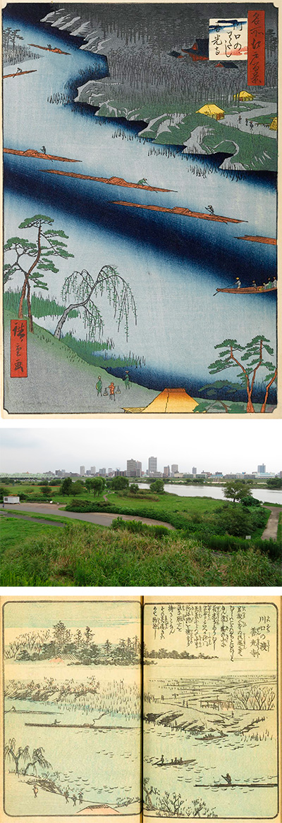
020 Kawaguchi Ferry and Zenkoji Temple is a bird's-eye view of the opposite bank from the Akabane side of the current National Route 122, Shin-Arakawa Ohashi Bridge. In this painting, there are many parts that feel the atmosphere of the times and the social conditions of the time.
This picture is the northernmost picture in the Edo 100 series. It is the so-called edge of Edo.
First, let's look at the picture from below. It depicts a tradesman-like person carrying a balance pole waiting for a new ship, two travelers, and a dock. This "Kawaguchi Ferry" was a place to cross the Arakawa River on the Nikko Onari Road. Nikko Onari Road is what is now called National Route 122, also known as Iwatsuki Kaido, and was the approach to Nikko, which enshrines the first shogun, Ieyasu Tokugawa, from Edo.
After leaving Edo Castle, the group of Nikko worshipers came to Hongo on Nakasendo instead of Nikko Kaido, entered Iwatsuki Kaido at Hongo Oiwake on the side of the University of Tokyo, crossed Arakawa at Iwabuchi via Komagome and Oji, and passed through Kawaguchi. Fortunately, I joined Nikko Kaido and headed for Nikko.
In the Shogun family, this Toshogu shrine pilgrimage is carried out on a large scale, and even the procession of the 8th Shogun Yoshimune, who is famous for his frugality, has a record of 130,000 companions, 230,000 people, and 320,000 horses. there is.
When such a large procession crossed the Arakawa, many ships were lined up in parallel with the flow of the river, and many wooden boards were lined up on it, a temporary bridge was set up, and the Arakawa was crossed. That's right. It seems that the reason why I didn't use Senju Ohashi was to avoid congestion, but it seems that security was the highest priority.
On the right side of the center of the picture, the ferry is heading to the opposite bank. Six rafts of timber bundles are drawn on it. At that time, the Sumida River, which was called Okawa by the common people, called Arakawa upstream from Kanegafuchi. The main part of this Arakawa water transport was the raft that carries the timber. From upstream Chichibu, we were carrying a large amount of timber to the city of fire, Edo. Furthermore, Edo was still undergoing reconstruction due to the great Ansei earthquake that occurred two years before the publication of this painting. Hiroshige probably drew a lot of rafts while feeling such a thing.
In particular, compared to the composition of the flat picture book Edo souvenir that Hiroshige drew before this painting, Arakawa intentionally meanders and blurs the center of the river. Coupled with the vertical composition, it makes me feel that the future will continue and the world will continue.
If you look at the top of the picture, you will see a red hall that stands out. There are pine trees in the back, zelkova and bushes in front of them, and reeds in the river. Kawaguchi Zenkoji stands in the beautifully maintained area. It is a temple that was promoted and built by a senior priest in response to the spirit of Shinano Zenkoji in 1197.
Shinano Zenkoji, there is also the opening of the Amida Buddha, and it seems that Shinano opened the book every 33 years, while Kawaguchi opened the book every 17 years.
It is said that in the year of the opening of the book, a large number of people visited from Edo, and Kawaguchi, which is easier than going to Shinano, was crowded with good men and women who wished for the same benefits as Zenkoji.
The red hall of Zenkoji Temple, which was also a cultural property of the prefecture, was burnt down in 1959 and is now transformed into a modern building. Furthermore, it seems that further renovation and maintenance is planned after the ongoing super levee construction of Arakawa is completed.
I actually went to that place. The angle is quite low, but it is a picture of Zenkoji from me at Kawaguchi Ferry. Zenkoji is a small green roof between the skyscrapers in the center.
This is a video taken counterclockwise from the base of the bridge, looking in the direction of Akabane.
The Shin-Arakawa Ohashi Bridge, which replaces "I of Kawaguchi" at that time, boasts a considerable amount of traffic as a bridge connecting the main lines of Saitama and Tokyo. On a clear day, you can see the beautiful Mt. Fuji to the west from here.
The riverbed of Arakawa is now used as a driving school, baseball and soccer ground. In addition, a cycling road of about 90 km has been developed from Kasai Rinkai Park at the mouth of the river to Higashimatsuyama Forest Park, making it a mecca for biking.
The rivers you can see at the beginning and end of the video are the Shingashi River flowing from Kawagoe.
I uploaded a photo taken from the site and overlaid Hiroshige's picture.
After all, the angle is low, so I relied on Apple MAP again.
Even so, it makes me realize that Hiroshige's feelings for painting, composition, angle, and deformation are exquisite.
