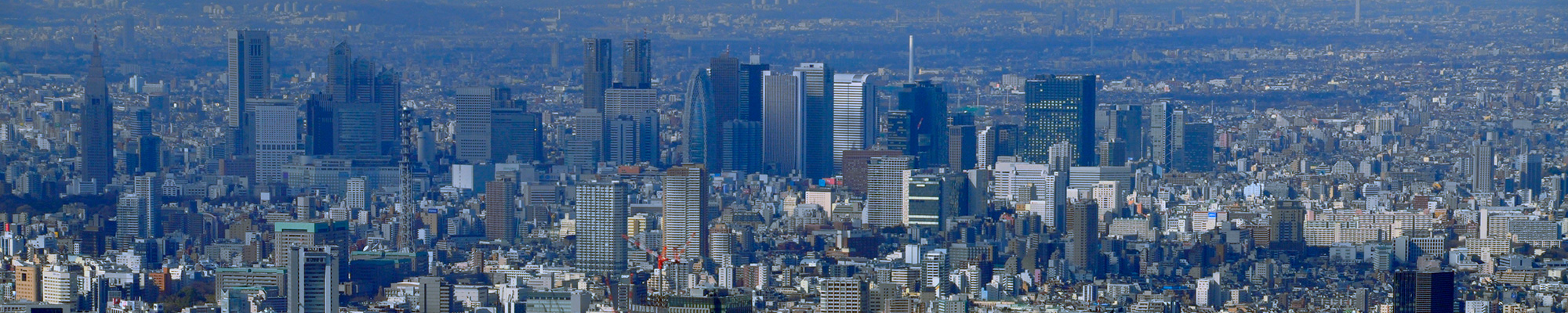

I actually visited one of my favorite places, One Hundred Famous Views of Edo, drawn by Hiroshige Ando, and what the scene is like now.
I actually visited the famous Edo 100 views drawn by Hiroshige Ando, which I love, and what the scene is like now.
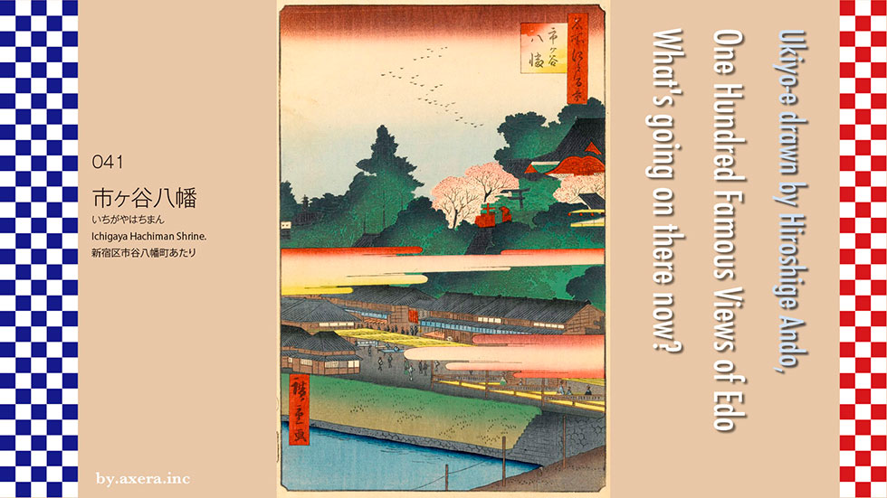
041 Ichigaya Hachiman Shrine is a view of Sotobori-dori from the current JR Ichigaya station area.
First, I used Applemap to find out where this perspective is. I added a red gradation around the viewpoint of Hiroshige's painting. It seems to be the view from the front of JR Ichigaya station or the area where you started to cross the bridge over the moat.
I put an old map, "Ansei Revised Miedo Daiezu" on it. At that time, a box-shaped gate called Ichigaya Gomon was set up around Ichigaya Station on the south side of the moat, and a part of it is still left and can be seen next to the park in front of the station. You can see the word Toenji in the direction of the viewpoint, but this is Toenji, a Betto of Ichigayahachiman, which is the management temple of the so-called Hachiman Shrine.
On this map, the place marked Owari-dono is the Owari-Tokugawa family's upper residence, which was used as a military site from the Meiji era, and is now Ichigayahonmura-cho, where the Ministry of Defense, the Self-Defense Forces, and related facilities cover this area. There is using the whole area. On the right side of the moat is Bancho, where small samurai residences stand.
I tried to overlay Tenpo's old map, which is a little clearer, along the Sotobori in three forcible ways. The samurai are white, the vacant lots are green, the temples and shrines are pink, and the townspeople's residences are shown in gray. If you take a closer look, you can get a glimpse of the lifestyle of the samurai society at that time. Hatamoto, whose name is written in Bancho, was mostly in charge of the shogunate's business. However, since the number of job titles was limited, I can imagine that even Hatamoto would have had a hard time just getting a job title.
Now, let's take a closer look at the actual Hiroshige painting.
The whole picture is a little dark, probably because the bird of the geese is imagining the evening. At the far left, you can see the fire lookout tower of the Owari-Tokugawa family, the head of the Tokugawa Gosanke family, and the others are blurred by haze clouds. Around this time, it's a unique method of Hiroshige that hides things that affect publication.
Next to the cherry blossoms in full bloom in the middle is the tea tree Inari. I said it. There is a bell tower beside the torii gate of Inari, and there are eight officially recognized bells in Edo, which inform the citizens of Edo of the exact time every hour.
Next to the cherry blossoms in full bloom in the middle is the tea tree Inari. People with eye diseases stopped drinking tea at the beginning of the year, decided the number of days and prayed, and it was effective, so many worshipers were gathered. There is a bell tower beside the torii gate of Inari, and there are eight officially recognized bells in Edo, which inform the citizens of Edo of the exact time every hour.
The large building on the right is Ichigaya Hachimangu, which was built in 1476 by Dokan Ota by soliciting Tsurugaoka Hachimangu in Kamakura. At the time of its construction, it was inside the Sotobori, but with the renovation of the Sotobori around 1630, Bancho became a samurai land and was moved to its current location. Although it was called Kameoka Hachiman for Tsurugaoka Hachiman, it declined for a while, developed after receiving the patronage of Keishoin, the mother of Tokugawa 5th Shogun Tsunayoshi, and is now counted as Edo 8 Hachiman.
The right side at the bottom of the picture is the bridge over Ichigaya Gomon, the left is Sotobori, and the shore is lined with water teahouses, and a small teahouse is also drawn. Furthermore, it is said that there was a playhouse and a place where I play by a bow, and the area around this area was one of the leading entertainment districts in Edo.
It is said that this painting is the second generation because it was published after the first Hiroshige died of cholera.
Hiroshige II is a picture book Edo souvenir and has released a picture called Ichigayahachiman Omotemon-mae. The structure of the painting is almost the same, and it is explained that it is the total guardian of Ichigaya, and along with the effective tea tree Inari, people are always coming and going and it is crowded.
It is written in a little more detail in the Edo Famous Places drawn by Saito Gekkin. Next to the Hachimangu Shrine, there are a Kagura hall, a teahouse, a playhouse, and a statue of Dainichi Nyorai, which seems to have been quite large. Today, this area is a preparatory school building or condominiums.
I actually went to this place. I can't see anything to the point of disappointment. Actually, the main shrine of Hachimangu is located behind the blue prep school sign in the center of this photo.
This is a picture of the direction of Iidabashi from the viewpoint. The building on the right is Hosei University.
This is a photo of the stone steps climbing Hachimangu. The place where many red lanterns are lined up on the left side is the tea tree Inari, which is said to be effective against eye diseases.
This is the current Hachimangu Shrine. From Apple Street View.
I tried turning the camera in the direction of Iidabashi from the Ministry of Defense side. The place that was one of the leading entertainment districts at that time is now Sotobori-dori, which has a lot of traffic.
Please see this at the end. This is a photograph published in "Opposition of past and present One Hundred Famous Views of Edo" published in 1918. At that time, Hachimangu still looked like Hiroshige's painting.
I tried to fit the current photo from Hiroshige's point of view into the picture. Even though this is the actual scenery today, it is so different from that time that I am disappointed.
In this Edo 100 series, there was a thing that the object itself disappeared. However, it is too sad that the object is still in existence but cannot be seen at all due to the development.
 I actually visited one of my favorite places, One Hundred Famous Views of Edo, drawn by Hiroshige Ando, and what the scene is like now.
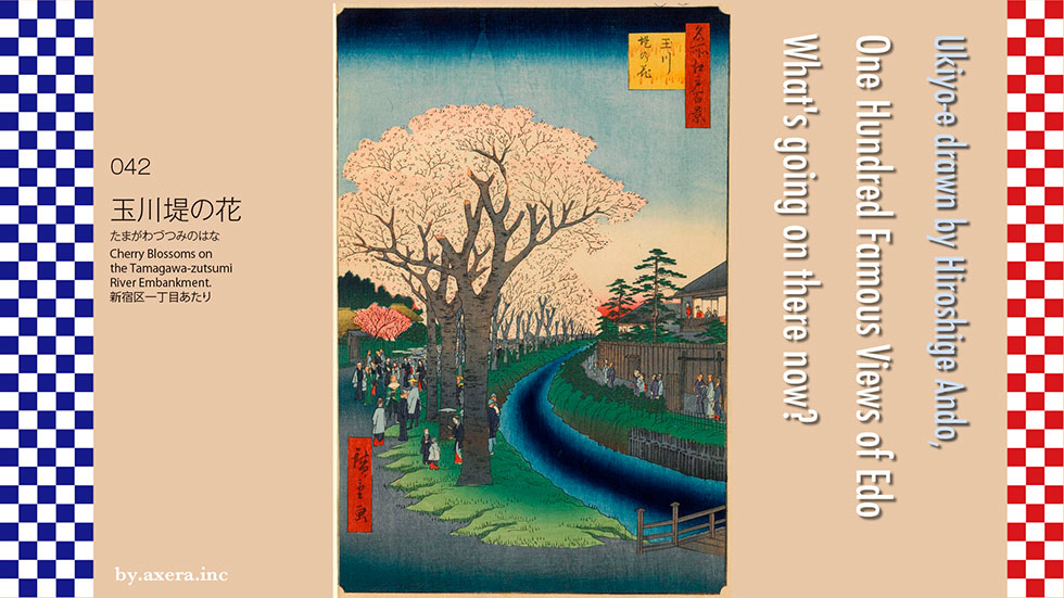
Cherry Blossoms on the Tamagawa-zutsumi River Embankment at 042 is a picture of the west side from the signal area on the south side of Shinjuku Gyoen Station on the Marunouchi Line, south of Shinjuku 1-chome. There were various opinions from experts about where Hiroshige drew this picture, but there was no definitive decision. So, I looked up the old map and found the true point of view. The points that decided the position were the bridge depicted in the picture and the samurai residence.
First of all, we will overlay the old map of the time on the modern map, so please have a look.
First, I took a look at the current Apple map and put the usual red gradation in the place that would be the viewpoint.
The map of the Yotsuya area in 1853 and the map of Sendagaya in 1862 were both distorted and forcibly overlaid to match the current map. What is noteworthy here is that there is a bridge, the north side of the water supply is a townhouse, and the south side is a samurai residence.
In addition, I covered it with in1858, which was connected to one piece. Two years after the painting was drawn, it is the year when the first Hiroshige died. The names of the samurai residence have changed, but the structure of the city is the same.
Just in case, I also covered a fairly accurate map of the early Meiji era. You can see that Tamagawa Aqueduct bends to the right from the viewpoint, just like the picture.
I went to see the model of Naito Shinjuku at that time at the Shinjuku Historical Museum in Yotsuya Saneicho. The front is the mansion of Naito Suruga no Kami and Okido gate of Yotsuya, and the farthest is the intersection of Oiwake, where Isetan is now. Tamagawa Aqueduct and the cherry blossoms on its bank are also reproduced. The main street on the right is Shinjuku Dori, that is, Koshu Kaido at that time.
I also put Hiroshige's point of view here with a red gradation. In fact, the bridge here seems to have been a little closer. Tamagawa Aqueduct There is a townhouse on the right side, but the samurai residence on the left side has not been reproduced.
Now, based on this, let's take a closer look at Hiroshige's paintings.
There is a bridge in front, and Tamagawa Aqueduct slowly flows from the back right. A large row of cherry blossom trees continues on the left side, and many cherry blossom viewing visitors come there. The samurai residence with the crown tree gate is on the far left, and the Meshimori women are watching the cherry blossoms from the second floor of the Hatago on the right.
There are several intertwined episodes in this picture. First, take a look at Yotsuya Okido gate, which is about 300 meters in front of you from the viewpoint of this painting, drawn by Saito Gekkin in the Edo Famous Places. Surrounded by solid stone walls, Okido gate manages people and supplies entering and exiting Edo from the Koshu-Kaido. In other words, the place where Hiroshige's paintings were set is outside Edo.
In this picture, Saito Gekkin also depicts the bustle of Naito Shinjuku. Among the Edo Five Routes, the Koshu-Kaido played a role as a retreat in the event of the fall of Edo Castle. Perhaps it also played a role in protecting it, Naito Suruga no Kami of the Takato Domain in Shinano Province was given a vast land by the Shogunate and set up a mansion with his vassals in this land. The samurai residence on the left side of Hiroshige's painting is believed to be the residence of the Naito clan's vassals.
The first inn on the Koshu-Kaido was Takaido, which was about 16 kilometers away from Nihonbashi, so in 1699, Naito Shinjuku was newly established in Tsunohazu Village, which is also the junction with the Ome Kaido. After that, inn and teahouses increased, and it will develop as a prostitute town. However, in 1718, the entire post station was abolished by the shogunate due to the "prostitute business crackdown" that rival Yoshiwara had requested.
However, in 1772, Naito Shinjuku reopened for the first time in more than 50 years.
At this time, it was not allowed to have a prostitute in the post station, but Meshimori women and teahouse maiden were placed as practical prostitutes in the name of serving customers. The regulation that "up to 2 Meshimori women per inn" was relaxed, and up to 150 people are allowed in the inn. Naito Shinjuku was the second busiest after Shinagawa-juku due to the de facto lifting of the ban on prostitutes, and its prosperity continued until the Meiji Restoration. There was such a background in the many inn and Meshimori women drawn on the right side of Hiroshige's painting.
Tamagawa Aqueduct, which was in the middle of Hiroshige's painting, was drawn in 1653 from Hamura, which is 42 km away, to the water station next to Yotsuya Okido gate, and is a waterway for the purpose of supplying drinking water throughout Edo City. From Yotsuya, go through Hanzomon to Edo Castle, the other from Kinokuni-zaka to Akasaka, and other than that, head south to Shibutani River, and changed its name to Furukawa via Azabujuban. It was pouring it into Edo Bay.
This Tamagawa Aqueduct has the name of purifying water, and many cherry blossoms have been planted around Koganei, making it a famous place alongside Ueno, Oji, and Gotenyama. However, by the end of the Tokugawa shogunate, old trees became prominent in Koganei, and it was Naito Shinjuku that stood up to create a new famous place.
According to Minoru Harashida's "Mystery Solving Hiroshige" Edo Hyaku, "a project to plant cherry blossoms at the Tamagawa Aqueduct in Naito Shinjuku was underway in the year this painting was published. Officials also obtained permission from the deputy officer and the magistrate, and planted 76 large and small cherry trees. However, it has not been delivered to the magistrate who manages Tamagawa Aqueduct, which is essential, and it is removed by touching the reverse scale of Important post of the Shogunate and old medium Abe Ise no Kami Masahiro who happened to come to the inspection by a long ride.
Therefore, even the model of Naito Shinjuku at that time in the Shinjuku Historical Museum does not have an actual row of cherry blossom trees.
So why did Hiroshige draw a landscape he hadn't seen before? The year before Hiroshige published this painting, the great earthquake of Ansei caused devastating damage to Edo. About half a year after that, I think Hiroshige wanted to cheer up the changing Edo. Since a new cherry blossom viewing spot has been created on the back street of Naito Shinjuku, I think we have started a promotion for the citizens of Edo, such as let's all do our best. In fact, on the wall of the Shinjuku Historical Museum, there was a series of three paintings of "Cherry Blossoms on the Tamagawa-zutsumi River Embankment" drawn by Hiroshige. The publisher, Noshuya, is a local shop in Yotsuya.
Well, I actually went to this place. The road in front of you is where Tamagawa Aqueduct was flowing.
I added a red gradation of viewpoint to Google photos. The Naito family's residence has been transformed into Shinjuku Gyoen, and the inn has been transformed into a building.
This is a photograph of Yotsuya Okido gate from Hiroshige's point of view. The bush on the right still has a small amount of Tamagawa Aqueduct.
This is the former Naito Suruga no Kami's mansion, which is the front entrance of Shinjuku Gyoen seen from Shinjuku station side.
I tried to fit the current actual photo into Hiroshige's painting.
The creation of a famous place for cherry blossoms, which was developed in this area about 170 years ago, was crushed by the voice of a powerful crane derived from a mistake in notification. By the way, is the voice of the crane, a powerful person, really working in the right direction in Japan today, which is a disaster of Corona?
There is a record that the cherry blossoms that were removed at that time were used to replant the cherry blossoms in Koganei.
I actually visited one of my favorite places, One Hundred Famous Views of Edo, drawn by Hiroshige Ando, and what the scene is like now.
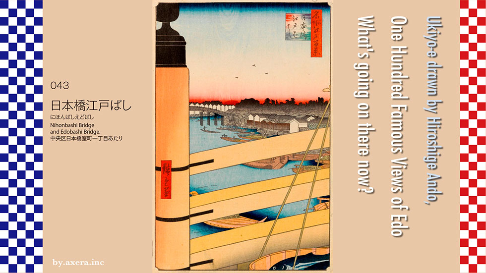
043 "Nihonbashi Edo Bashi" is a picture of the south side of Edo Bridge seen from the north end of Nihonbashi over the railing of the bridge.
First take a look at the modern Apple Map. The Nihonbashi River runs from the upper left to the lower right. The north side of Nihonbashi is Nihonbashi Muromachi 1-chome, that is, the Mitsukoshi side. The south side is Nihonbashi 1-chome and Coredo Nihonbashi side.
I tried to forcefully overlay the cut-out drawings of Nihonbashi and Tsukiji from the time of Tenpo. The road position hasn't changed much around here. The moat is filled to some extent. The place where the town name is drawn in the gray part is the place where the townhouses of the common people of Edo are lined up.
Just in case, I enlarged and overlaid the map connected to the one that was revised in the year when this picture was announced. You can see that the current Edo Bridge was built over the moat on the east side. You can also see that the Metropolitan Expressway runs along the moat.
I tried to overlay different map. You can see that the south end of Edo Bridge is a slightly large fire protection area, and the warehouses are lined up.
Just in case, I enlarged and overlaid the map connected to the one that was revised in the year when this picture was published. You can see that the current Edo Bridge was built over the moat on the east side. You can also see that it runs along the moat on the Metropolitan Expressway.
Finally, I returned to the modern map.
Let's take a closer look at Hiroshige's paintings. About three birds are flying in the sky, and a ornamental railing top and a balustrade are drawn on the left side, and the bridge itself occupies more than half of the picture. The bridge with this ornamental railing top is a high-class bridge, and it seems that there were only Kyobashi and Shinbashi in the town other than samurai residences
In the distant view, the red gradation before dawn, and if you look closely, you can see the rising sun, which is just beginning to show its face. Below that, the bridge in front of the white warehouses is Edo Bridge. This warehouse is the warehouse of Kobunacho 4-chome as seen on the map, surrounded by a moat from 1-chome to 4-chome, and there was a shipping wholesaler to Oshu.
On the right side, the blackish picture is the main lumber town, and if you look closely, you can see a forest of lumber-like objects. Hiroshige is also drawn in great detail around here.
As you can see on the map, the right side of Edo Bridge, that is, the south side, was a fire protection area. This is the so-called Hirokoji, which was created by relocating Yokkaichi Town, which was here after the Great Fire of Meireki in 1657. It was a famous red-light district with a line of the store where a bow is struck, teahouse, storyteller, and barber.
Many warehouses and boats are drawn on the river side. One is the Yokkaichi riverbank, which handles salt-dried foods.
The other, which is cut off in the picture, is the Kisarazu riverbank, which carries travelers and supplies to and from Kisarazu in Chiba. This area was like a shopping center now.
At the bottom of the picture, the bonito in wooden tub is symbolically drawn. This depicts only a part of a merchant called the Botefuri, who sells fish on a balance pole and sells them around the city.
On the north side of Nihonbashi, there is the kitchen of Edo and the banks of the fish river, and the fish that have been carried through the night are carried to the town of Edo by the Botefuri who gathered before dawn.
It was said that the Edokkos at that time were smart about not paying attention to the amount of money for the first item. In particular, the bonito caught in Sagami Bay was considered to be the best at this time, and Hiroshige seems to have produced such a drama with this bonito.
Hiroshige also draws Nihonbashi on the first piece of this Edo 100 series. Unlike this "Nihonbashi Edo Bashi", the viewpoint is looking at Mt. Fuji over Nihonbashi. Take a closer look at the winter morning landscape and the early summer morning landscape.
There is one that Hiroshige II drew with almost the same composition as the first generation. Perhaps it depicts the New Year's dezomeshiki, a headband is flying in the air. The balustrade of the same Nihonbashi and the Yokkaichi riverbank are drawn in more detail. It is drawn so that the fire extinguisher with a hook can be seen through.
The first Hiroshige is a series of three pieces, and also draws a panoramic picture of Nihonbashi. The left side is the Kisarazu riverbank, which is the current Nihonbashi police box. To the left is Nishikawa, a futon. The right end is Mitsukoshi, but it is cut off. People are drawn small for the cityscape, creating a feeling of being extremely busy.
Hiroshige's senior, Kuniyasu Utagawa, also comically depicts the bustle of the fish bank of Nihonbashi in three consecutive pieces. At the fish market, you can see that various fish and shellfish are traded in addition to bonito. There are so many people on Nihonbashi that they are about to fall, and the exaggeration is interesting.
Hiroshige also depicts the moist Nihonbashi in the snowy landscape. It expresses the air that is welcoming the morning when both Edo Castle and Mt. Fuji have calmed down on a snowy morning. On the left side of the picture, the Kisarazu riverbank where people in red kimono come and go is just the place where the shop has just opened.
Hiroshige also depicts Nihonbashi, which has few people due to white rain. You can see the people on the bridge going back and forth in the sudden rain. The railings of the bridge, the cityscape, and Edo Castle, which have changed color due to the rain, are drawn to smell.
That Katsushika Hokusai also depicts Nihonbashi in "Thirty-six Views of Mt. Fuji". Ichikoku Bridge, Edo Castle, and Mt. Fuji are drawn in the back, and the perspective is exaggerated. Nihonbashi in the foreground is drawn only by people, and the taste is completely different from Hiroshige.
I actually went to this place. However, I can't see anything because the Metropolitan Expressway covers it.
I tried to take a part of the balustrade into view by the left side, but it's the same.
Apple Street View, which is a little behind, looks like this, but I can't see anything on the other side.
Still, I tried to fit this photo into Hiroshige's painting.
The reason why this happened goes back to the last Tokyo Olympics. This is because the Metropolitan Expressway was built around the moat that remained at that time because it was cheap and could be done immediately in time for the 1964 Tokyo Olympics.
Currently, it seems that construction to underground the Metropolitan Expressway has begun, but it is scheduled to open in 2035 and to be completely removed in 2040. Until then, the scenery that doesn't look like that time and the sky can't be seen will continue. Hiroshige and the many painters who painted Nihonbashi would never dream of this happening now.
 I actually visited one of my favorite places, One Hundred Famous Views of Edo, drawn by Hiroshige Ando, and what the scene is like now.
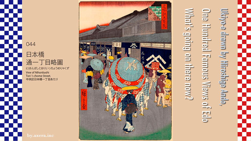
044 "Vew of Nihonbashi Tori 1-chome Street" is a picture of Coredo Nihonbashi seen from the current Nihonbashi intersection in the very hot summer afternoon, all wearing umbrellas and sedge hat.
First of all, please see what this "Nihonbashi Tori 1-chome Street" is from the current Apple map. When Edo Castle was first built, the front of Edo Castle was facing north, that is, the Oshu-Kaido. The orange line in the map.
However, in 1603, when Ieyasu Tokugawa was appointed Shogun, the main street was formed around Nipponbashi, which was built in that year. Eventually, Nakasendo and Tokaido on the Edo Five Routes were connected by Nihonbashi, and a road that runs north-south through Edo was completed.
Of the main streets that connect north and south, the area from Kanda Sudacho to Kanasugibashi, which is ahead of Hamamatsucho, has come to be called "Toricho". The blue line on the map.
In the latter half of the Edo period, "Toricho" began to call from Nihonbashi to Kyobashi, and various long-established stores lined up from Tori 1-chome to 4-chome. The red line on the map.
I enlarged the Nihonbashi area on the map. The blue line is the early "Toricho" and the red line is the "Toricho" that was called from the late Edo period, and there were 1 to 4 chome from the top. In particular, Tori 1-chome was the place with the highest land prices in Japan at that time, and it was the status that merchants opened stores here.
I added a red gradation from Hiroshige's point of view. Furthermore, I tried to cover the picture map at the time when this picture was published from above. It's a little off.
Please see the pictorial map of the time, which was an enlargement of the area around "Tori 1-chome" seen from Edo Castle at that time. From Nihonbashi on the left, the road in the direction of Ginza on the lower right is "Toricho", and I put Hiroshige's painting on it. It means that there was such a shop in this place at that time.
I also replaced the map with a modern Apple map. With this, you can imagine the cityscape at that time.
Let's take a closer look at Hiroshige's paintings. The first thing you see is the Shirokiya on the right. Starting from a timber dealer in Kyoto, he opened a booth shop in 2-chome in 1662, moved to this place in 1665 and became a prosperous kimono dealer, and eventually Echigoya (currently Mitsukoshi) and Daimaruya (currently Daimaru), it has become one of the three major kimono stores in Edo.
After the Meiji era, Shirokiya became a pioneer of department stores, and after the earthquake, fire, and war, it became a subsidiary of Tokyu Department Store in 1956, and the name of Shirokiya disappeared. Nihonbashi 1-chome Mitsui Building, commonly known as Coredo Nihonbashi, is now built in this place.
At the right end of the picture is a man in sedge hat who is holding a melon sold at a street stall. The oriental melon (call Makuwa Melon) is derived from the fact that Makuwa Village (now Motosu City) in Mino Province was the production center. The shogunate called in farmers so that they could grow it in Edo, and it was actively cultivated around the current village of Naruko Nishi-Shinjuku. At that time, sugar was expensive, so sweet fruits were very popular among the Edo people as water confectionery.
The back side of Shirakiya, it's Tokyo-an, a soba restaurant. At the storefront of Shirokiya, there is also a happi coat-clad servant who came out from Tokyo-an with a soba piled on a red weight on his shoulder. This Tokyo-an changed its name to "Tokyoan" in the Meiji era, and there is a record that it was on the back alley Kihara Shin-michi even when Shirokiya expanded the store.
The picture depicts two men coming out of the Kihara Shin-michi on the main street of Tori 1-chome. Beyond that, it is said that there were tatami mat wholesalers from Omihachiman, from the store of Bandenbei from Omihachiman to the store of Jingoro Nishikawa near Nihonbashi bridge. Although not depicted in Hiroshige's paintings, this Nishikawa Jingoro store is today's futon Nishikawa. At that time, it is said that the mosquito net blockbuster, which was invented by Jingoro, got the business on track and expanded its business as a mosquito net wholesaler and bow wholesaler for several generations based in Nihonbashi.
Opposite Tokyo-an, a group of four women in good kimono, who seem to be the daughters of a large store merchant, are walking with an umbrella. In front of it, there is a group walking with a two-tiered umbrella called a long-handled two-covered hat. This is a group of Kappore dances, which is a change of Sumiyoshi dance at Sumiyoshi Shrine, and was popular as a street performer in Edo at that time. Several people, dressed in white cotton obidomes and dyed with ink, dance around two-covered hat. While dancing, sing funny songs and get applause and fees from the people.
This kappore dance gradually changed in the Meiji era, and later began to dance with a shaved head in the form of a dyed yukata and a flat belt. Eventually, it developed as a taikomochi and a yose performance, which Taikomochi is good at. However, Hiroshige's Kappore dance at that time was a street performance, so it had an impact and fun that stopped passers-by.
The stylish woman in the yellow sedge hat depicted in the foreground is a street entertainer named Female Tayu. In the early days, she visited each house, begged for shamisen and kokyu, and on New Year's day, I wore a bird chasing hat and sang a bird chasing song to go around the houses.
The kimono of the female tayu was supposed to be worn with cotton, and the crepe was applied only to the collar, and the dyeing and color matching were elaborate. After the Tenpo Reforms, she was sometimes called and sang in addition to street, and gradually the female entertainers who performed the performances were also called female tayu. Among them, those with excellent looks were also depicted in Ukiyo-e, and Kabuki was the subject of Kabuki. Toyokuni Utagawa also draws a female entertainer in Edo in the series "One Hundred Famous Beauty in Edo". I draw it with a very glossy feel.
In this picture, many people wearing cotton are drawn. It is said that this painting by Hiroshige was drawn for the promotion of Shirokiya.
I actually went to this place. The right side of the photo is Coredo Nihonbashi, the left side is Nishikawa Futon, and the alley between them is Kihara Shin-michi.
Here is a photo that I took a closer look at to match Hiroshige's painting. Directly below is Tokyo Metro Nihonbashi Station. Coredo in Coredo Nihonbashi means "core Edo", which means the center of Edo.
This is a picture of Nihonbashi in the center. This side is the beginning of the Tokaido, and the tip of the bridge curves slightly west to become the beginning of the Nakasendo. The rounded building on the left is the Mitsukoshi New Building, and the blue building on the right is Coredo Muromachi.
I tried to fit modern photographs into Hiroshige's paintings.
Hiroshige's paintings had a very Japanese atmosphere, so there is no sign of it. When this Coredo Nihonbashi was built, the main tenant was Merrill Lynch. Merrill Lynch Japan is a Japanese corporation established in 1998 to take over the business network of Yamaichi Securities, which went bankrupt. It is now also acquired by Bank of America and is one of the largest financial institutions in the world. The center of Edo has become the United States. Yes, this country may have become the United States without our knowledge.
 I actually visited one of my favorite places, One Hundred Famous Views of Edo, drawn by Hiroshige Ando, and what the scene is like now.
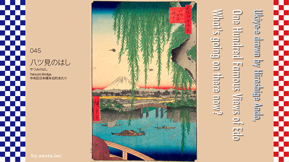
045 "Yatsumi Bridge" is a picture of the direction of Edo Castle from Ikkoku Bridge, opposite the Bank of Japan.
First of all, please check the current situation on Applemap. Hiroshige's point of view is almost west from the top of Ikkoku Bridge, which extends from the intersection of Gofukubashi to Tokiwabashi on the current Sotobori-dori. Let's represent this viewpoint with a red gradation.
I put the map of that time on this from above. The title of this picture, "Yatsumi Bridge" is another name for Ikkoku Bridge, and is derived from the fact that eight bridges, including Ikkoku Bridge, were visible from this location. The orange circle on the map is Ikkoku Bridge, Zenigame Bridge and Dosan Bridge in front of the viewpoint, Tokiwa Bridge on the right, Gofuku Bridge and Kaji Bridge on the left, and Nihonbashi and Edo Bridge on the back side of the viewpoint.
Currently, the moat itself has been buried and removed from Zenigame Bridge and Dosan Bridge. Tokiwa Bridge has become two old and new Tokiwa Bridges, and the restoration work has just been completed the other day. The outer moat of Gofuku-bashi and Kaji-bashi became roads, and the bridges were demolished and remain as the names of the intersections. Nihon-bashi and Edo-bashi have been moved a little and still remain today. Ikkoku Bridge has become a new and splendid bridge, leaving only the old main pillar as a memorial, and is a 6-lane Sotobori-dori.
Let's take a closer look at Hiroshige's paintings.
The upper half depicts a large willow trunk and lush, hanging leaves. Two swallows are flying comfortably in the sky, and Mt. Fuji, which is celebrating summer, is depicted in the distance. Is it Tanzawa that is drawn with Mt. Fuji? In front of it, Edo Castle is drawn with a dark grove.
The building that looks a little high in Edo Castle is the observatory tower. The moat that extends from the front to the back is called Dosanbori, and it seems that the turret of Wadakuramon is visible beyond that.
The small bridge in front of the turret is Dosanbashi, the left is the Tatebayashi Domain Akimoto Tajimanokami's upper residence, and the bridge in front is the Zenigame Bridge.
Please see the map of the current Geographical Survey Institute where you can see the current height difference. The yellow areas are the hills, and the areas that change from green to blue are the low areas of the land. You can see that Edo Castle is located at the tip of the Musashino Plateau.
It's pretty rough, but when Ieyasu Tokugawa came to Edo, water was getting into the lower part in this state. From the area around Shinbashi to Iidabashi, there is a shallow sea and marsh called Hibiya Inlet, and from Nihonbashi to Ginza, sand has accumulated and it has become a peninsula on a slightly elevated ground, and it was called Edo-Maejima.
In 1590, after Ieyasu Tokugawa entered Edo and secured a residence for his vassals, restoration work on the former Edo Castle built by Dokan Ota began. Landfill of the Hibiya Inlet began with the remaining soil from the construction of the castle, and an artificial moat was dug for the first time by connecting it to the "Hirakawa (Nihonbashi River)" that leads to the sea for use in transporting materials. It became land. Since the physician to shogun, Dosan Imaouji, lived here, this moat came to be called Dosan moat.
From 1603, when Ieyasu Tokugawa opened Edo, he ordered daimyo nationwide to make a general contract, and a major remodeling of the city of Edo began. It was utilized. As Edo developed further, ordinary private houses in the Dosanbori area were relocated and transformed into a town where daimyo, who are important to the shogunate, live.
By the time Hiroshige painted this place, the left side of the painting, on the south side of the moat, was called the Kumamoto Domain Hosokawa Echizen no kami, the Tatebayashi Domain Akimoto Tajimano kami's mansion and Kitamachi Magistrate's Office, and on the right side of the painting, the north side was called "Otemon-mae", Fukui Domain Matsudaira Echizen no kami, the Shogunate, Daimyo under direct control, Mansion lined up, and there was also an account magistrate's office.
The bridge over Dosanbori, which is in front of the Sotobori, is the Zenigamebashi. The origin of this name is said to be that a bottle containing money came out during the excavation of Dosanbori.
In Hiroshige's painting, there are two other fishing boats that operate 4 armed scoop net, and one small boat called a tea boat that carries luggage from a large boat in small portions. This place is just at the intersection of Sotobori, Nihonbashi River and Dosanbori, and it shows that the traffic of boats was active.
The bridge where you can see the parapet at the bottom of the picture is Ikkoku Bridge, and it is the first bridge over the Nihonbashi River where Sotobori flows to the east. To the north of this bridge was Shonosuke Goto of Kinza, and to the south was Nuinosuke Goto, a purveyor of kimono for the shogunate. Goto, that is, the unit of measurement, 5to and 5to, became one stone(ikkoku), so the citizens of Edo fashionably called this bridge Ikkoku Bridge.
Well, I actually went to this place. This is a picture taken from the same place as Hiroshige's point of view. There is no Dosanbori and Zenigamebashi. Even so, it was supposed to be laughable.
This is the picture I took a little further back. In Hiroshige's painting, the Tokiwabashi Tower was just completed in the vicinity of the boat operating the 4 armed scoop net, and the highway over it made it impossible to see the other side at all.
This is a photo of Ikkoku Bridge seen from the north side. Sotobori-dori is on the left, and the current Gofukubashi intersection is ahead of the scenery.
This is Sotobori-dori, but it is actually the middle part of the current Ikkoku Bridge. The back of the front of the photo is the Yaesu exit of Tokyo Station.
Then I turned the camera counterclockwise from Hiroshige's point of view.
Along with the noise of the Metropolitan Expressway and Sotobori-dori, the Gofukubashi ramp, which boarded the Metropolitan Expressway from Ikkoku Bridge, appeared.
After passing through Toyo Keizai, the Bank of Japan is ahead, and this intersection is Tokiwa Bridge.
The arched stone bridge is the Tokiwa Bridge built in the 19th century. The old Tokiwa Bridge is about 20 meters away, and the restoration and maintenance was just completed the other day.
I looked up at Tokiwabashi Tower from the Ikkoku Bridge. Even though this is still high enough, in 2027, the tallest torch tower in Japan, which is 390 meters long, is scheduled to appear.
Well, I actually tried to fit the current photo into Hiroshige's picture. I can't see anything at Tokiwabashi Tower and the highway because the viewpoint is low.
So, I tried to create a scenery like that by synthesizing the street view of Applemap and the scenery from Sky Tree and the summer scenery of Mt. Fuji.. There is no Tokiwabashi Tower or 390-meter torch tower in the photo yet, but a few years later, even this photo should have a large building like a giant torch.
Even so, it's completely unbelievable that the sea had entered here only about 400 years ago. What's more, it's amazing because it was remade by human hands. From the perspective of nature, there won't find any other creature as scary as humans.
 I actually visited one of my favorite places, One Hundred Famous Views of Edo, drawn by Hiroshige Ando, and what the scene is like now.
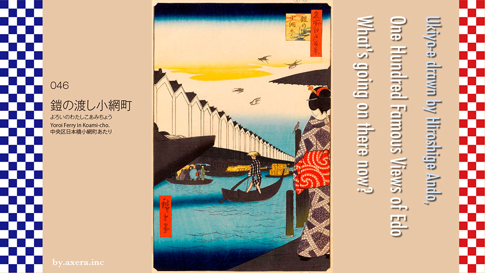
046 "Yoroi Ferry in Koami-cho" is a view of Koamicho from the departure and arrival point of "Yoroi Ferry" on the side of the current Tokyo Stock Exchange.
First, check the location on Applemap. In 1872, "Yoroi Ferry" became a bridge called Yoroibashi, which spans Nihonbashi Kabutocho and Nihonbashi Koamicho. In Nishizume, there was the Makino family residence of the Tango Maizuru clan, but now the Tokyo Stock Exchange is built on the site. The Metropolitan Expressway Loop Line runs above the Nihonbashi River. Let's represent Hiroshige's viewpoint with a red gradation.
I tried to enlarge this map further. I added a red gradation, which is also Hiroshige's point of view, and covered it with an old map of the time when this picture was drawn.
The white dozo that lined up in a row on the left side of the picture is the blue part of this map. Behind this was the mansion of Gagaku Sakai of Gunma and his relative, Matsudaira Etchu Mamoru of Fukui. The place where the small "Inari" is written on the left side of the green triangle has now moved a little northeast to become Koami Shrine.
Hiroshige is "Picture book Edo souvenir", which depicts the place where this warehouse was built from Edo Bridge. At that time, the riversides of Koamicho 2-chome and 3-chome were called the armor riverbanks, and were very busy as a center of supplies centered on rice and rapeseed oil. Hiroshige describes how the storehouses for storing it were lined up in the explanation of this painting, "It's like the Great Wall of China."
Hiroshige is a "picture book Edo souvenir" and also depicts "Yoroi Ferry" seen from the downstream. A large boat called Kisarazu ship is drawn on the right front side, and the actual "Yoroi Ferry" is drawn small on the left side in contrast. The commentary on this picture states that boats from Gyotoku and Kisarazu come and go day and night, and a lot of luggage is being collected. You can see how busy the armor river bank was at that time.
Please see the map that shows the height difference that you saw last time. Before Ieyasu Tokugawa entered Edo, the area that Hiroshige was supposed to have drawn was almost the sea, which was the eastern coast of Edo Maejima, which extends from Mt. Kanda.
A long time ago, when Minamoto no Yoshiie, who was ordered by the imperial court to conquer Oshu, tried to cross the sea from here to Shimousa, a storm was blowing. So, following the example of "Yamato Takeru" in the past, when he threw one armor (yoroi) territory into the sea to calm the dragon god, the wind and waves immediately became quiet and he was able to cross the sea safely. After that, this area came to be called "Yoroi no pool", and when this delivery was possible, it was called "Yoroi Ferry".
In addition, Minamoto no Yoshiie, who has made a triumphant return after the conquest of Oshu, created a "helmet (kabuto) mound" in the place where he buried his helmet in gratitude for the victory. It is located in the mansion of Matsudaira Izumimori, which is why this area has come to be called "Kabuto-cho". This is the reason why the current Tokyo Stock Exchange is commonly called "Kabutocho".
Also, when Taira no Masakado, who ruled this area widely around the beginning of the 10th century, took helmet from his neck, he dropped only helmet, made a mound there, and called it "Mt. Kabuto (helmet)" and worshiped it. For this reason, it is said that it has come to be called "Kabuto-cho".
Let's take a closer look at the actual Hiroshige painting.
In the summer sky, four swallows fly around like a flock, and underneath, the white storehouses of the shipping wholesaler on the banks of the armor river are lined up in a row, flowing from the left. Only the bow of a large ship called the Kisarazu ship pops out so as to pierce the warehouse.
From under the bow, various people riding the "Yoroi Ferry" are about to cross the crowded Nihonbashi River to the Kayabacho side. Beyond that, there are several small boats called tea boats, which are covered with barrels and sardines and loaded with yellow. This boat serves to divide and ship luggage from large vessels.
In the direction of "Yoroi Ferry", a high-speed boat called Chokibune is about to pass downstream first. A woman who seems to be the daughter of a merchant who is standing around busy and quietly staring at the situation from the shore is depicted in the back with a black parasol.
I actually went to this place now. Here is the picture.
The Metropolitan Expressway is also over here, so it's not a very enjoyable view.
This is a picture taken a little closer to the shore side, removing the oppressive feeling of the Metropolitan Expressway.
This is the photo that goes down a little further back, but it's not much different. The bridge on the other side is Kayaba Bridge over Shin-Ohashi Dori. Perhaps this point is the closest to Hiroshige's perspective.
This is a photo of the Tokyo Stock Exchange from the Koamicho side over Yoroi-bashi. Hiroshige's point of view is that people are walking in front of JPX right now.
By the way, I tried to fit the current photo into Hiroshige's painting. The point of view is a little different, but if you include the back of a woman, it seems that the photo is reasonably acceptable. However, I can't hear the hustle and bustle of the Edo period. You can see that the current Nihonbashi River is not only impassable for large boats loaded with luggage, but also for small fishing boats.
In the days of shipping wholesalers, the river was responsible for the transportation of goods, but nowadays, "roads" such as the Metropolitan Expressway that runs on the river and Shin-Ohashi Dori that intersects the river at right angles take the place. By the way, Shin-Ohashi-dori was directly connected to Tsukiji Fish Market, so it was called "Market Street" before the name changed.
The Tsukiji Fish Market was a modern facility that was created with consideration for water transportation and rail transportation during the shipping wholesaler era. However, it has now moved to Toyosu, which is only for land truck transportation. Oil has changed the times.
 I visited the 100 Famous Views of Edo, painted by my favorite artist, Hiroshige Ando, to see what the scenes look like today.
The painting "Seido and Kandagawa River from Shoheibashi Bridge" (047) depicts Yushima Seido and Shoheizaka in front of it in the northwest direction from Shoheibashi Bridge in today's Kanda Awaji-cho.
Let's check its location with Applemap.
Yushima Seido is located on the north side of what is now JR Ochanomizu Station. The Shoheibashi bridge is located at the end of the hill in front of it, going down in the direction of Akihabara. Hiroshige's point of view is shown in red gradation.
Next, I enlarged the map a little more. Yushima Seido and Shoheibashi Bridge are at this location. I also added a red gradation here, which is Hiroshige's point of view. On the map, the area around Ochanomizu Station is just at the top of the mountain.
I put an old map of the time of the Ansei era on top of this one to approximate the scale. I've also inserted Hiroshige's painting on the left, so you can get a general idea of the atmosphere.
Here is a map from the Geospatial Information Authority of Japan (GSI) that shows the difference in elevation, which we used last time.
The yellow area is the high land, and the blue area is the low land. Before Ieyasu Tokugawa entered Edo (now Tokyo), the light blue areas were marshes and seas where water entered. From Shimbashi to Iidabashi, Hibiya Inlet entered the area, and from Kanda to the south, it became a sandbar called Edo-maejima.
So you can see that the Kanda River runs unnaturally through the plateau of Kanda Mountain in the area circled in red here. Yes, this is an artificially created waterway by cutting down the mountain. In Hiroshige's painting, the somewhat exaggerated Surugadai on the left and the slope of Yushima Seido in front are remnants of this mountain, the Hongo Plateau.
In 1615, around the time of the fall of the Toyotomi family in Osaka Castle during the Battle of Osaka, Hidetada Tokugawa, the second shogun of the Tokugawa Shogunate, embarked on a full-scale flood control project to protect the city of Edo from the flooding of the Nihonbashi River. The Kanda River, which flowed into the Hibiya Inlet to the south from where the Tokyo Dome is now located, was channeled directly into the Sumida River by creating a straight waterway to the west. However, the Hongo Plateau mountains stood in the way, so it took about 30 years to complete the project.
The founder of the Sendai domain, Date Masamune, took on this difficult work, and from 1660, the fourth lord of the Sendai domain, Date Tsunamura, took on the widening work, which finally resulted in the current shape. Historians believe that the work was not only for flood control, but also to protect Edo Castle from threats from the north.
After the construction was completed, the valley cut out of the Hongo plateau was called Meikei by the common people of Edo and became a tourist attraction. The waterway was called "Sendai-bori" (Sendai moat) instead of Kanda River, and various river banks, including the Sakuma river bank, were built to carry water. The area was also called Ochanomizu because good water gushed out from the Hongo plateau strata in the middle of the cliff.
Let's take a closer look at the painting by Hiroshige.
The steep mountain on the left is Surugadai, so called because it was home to many samurai whom Tokugawa Ieyasu called from Sunpu.
The forest in front of the building, lined with Neri-bei walls with steps, is Yushima Seido.
A Neri-bei is an earthen fence made by piling up tiles and kneaded earth alternately, and covering the top with tiles. The striped pattern of the tiles and soil is beautiful, and was especially popular among samurai in the Kanto region. Yushima Seido is surrounded on all sides by this Neri-bei.
This is the current front of Yushima Seido. The name "Seido" means the mausoleum of Confucius and his disciples in China, and was originally located in Shinobugaoka, Ueno in 1690, when the 5th Shogun Tsunayoshi moved it there. The Seiden became the cathedral, and the Kobunkan became the Shoheizaka Gakumonjo (Shoheizaka School) under the direct control of the Shogunate, and is now called the "birthplace of Japanese school education.
There are a few passers-by on the slope in front of the sanctuary, and several boats with straw wrapped around their necks are floating in the Kanda River. You can see that the transportation network by boat has been developed since the Kanda River was opened.
The parapet on the lower right is Shoheibashi Bridge and the slope in front is Shoheizaka, which used to be called Aioi-zaka and Aioi-bashi respectively before the cathedral was moved. Before the cathedral was moved, the slopes were called Aioi-zaka and Aioi-bashi, respectively, but after the cathedral was built, the name was changed from Changping-go, the birthplace of Confucius.
I actually went to the place.
The Kanda River is now banked with concrete, with the JR Chuo Line on the left, the JR Sobu Line on the elevated right, and the Tokyo Metro Marunouchi Line tracks visible far ahead. Yushima Seido is just a faint glimpse of the grove of trees.
This is the view from the top of the Hijiribashi bridge, looking toward Akihabara and Hiroshige's point of view. The bridge you can see far ahead is Shoheibashi Bridge. Looking to the left from here is Yushima Seido, surrounded by a Neri-bei fence.
Now, I tried to fit the present scenery into Hiroshige's painting. In the original painting, Hiroshige deformed and exaggerated the height difference, but as far as I can see, it doesn't look like the mountains have been cut through. The Kanda River, which the Date Clan built after a great deal of work, is now surrounded by concrete and a huge sewer system, with trains from three different directions crossing it in a futuristic fashion.
For the great achievement of the Date Clan, I would like to at least change the name of the Kanda River back to "Sendai Bori".
 I visited one of my favorite places, "One Hundred Famous Views of Edo" painted by Hiroshige Ando, to see what the scene looks like today.
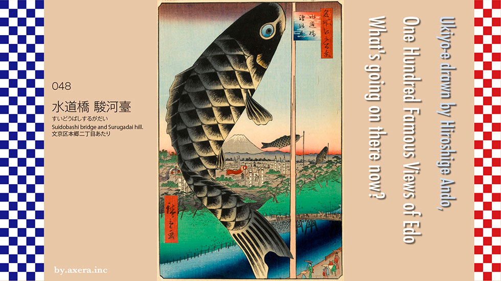
048 "Suidobashi bridge and Surugadai hill," is a picture seen from the west of Juntendo University, almost west-southwest from the Kanda River edge opposite Motomachi Park, about halfway between the current Ochanomizu Station and Suidobashi Station.
Please check the location first on Applemap. I added a red gradation to the place where I think Hiroshige's viewpoint is. At the time, the area bordered by the Kanda River was called Koishikawa to the north and Surugadai and Ogawamachi to the south.
The Kanda River is a man-made river that was created in the Edo period to prevent flooding in the Nihombashi River basin by cutting through the Hongo plateau and allowing water to flow directly into the Sumida River.
The Kanda River is officially the Kanda Josui, which started from Inokashira Pond and joined the Zempukuji River, Myoshoji River and Hanazono River to bring drinking water to Edo. This is the green channel on the map. So, to be precise, the current Kanda River was the channel for the surplus water after the intake.
The mainstream of the Kanda Waterworks flowed from the Sekiguchi Washing Weir, along the edge of Mejiro-dai and Kohinata-dai, across the Mito residence in Koishikawa, over the Kanda River in a flume, and through a tunnel in Surugadai to supply water to the interior of Edo Castle and the town houses in Kanda and Nihonbashi. The bridge over the Kanda River that was built upstream was called Suidobashi. It was about 10 meters downstream from the current Suidobashi.
Hiroshige also painted a picture from a little further downstream, including the gutter of the aqueduct. This is the painting on the left. You can see that the gutter is quite large and quite magnificent. The aqueduct can also be seen in the distance. The mountain with pine trees on the left is Surugadai.
The painting on the right is Hiroshige II's depiction of the Ochanomizu area without any pictorial exaggeration. Except for Mount Fuji, the rest of the city may have actually looked like this. The casual gestures of the citizens of Edo make it look more realistic.
Now let's take a closer look at the actual Hiroshige painting.
The first thing you will notice is the large carp streamer in the middle. So you can see that this painting was done right around the time of Tango-no-Sekku (Boys' Festival).
It was not until the Edo period that carp streamers, which were used to celebrate the growth of boys and pray for their health, became popular, and it seems to have been a custom only in the Kanto region. At first, it was a picture drawn on a banner, then it became a paper streamer, and around the middle of Edo period, it became a cloth streamer as we see today. However, they were not colorful like the ones we see today, but only black true carp.
Speaking of May banners, it seems that throughout Japan, family crests were first drawn on a flat banner, and then names, samurai pictures, helmets, armor, carp climbing waterfalls, stalacrocks, etc. were drawn and hung. In addition, only samurai were allowed to have banners. Helmets, armors, and Shoki-sama eventually developed into May dolls. It is said that Shoki-sama was the god who purged the illness of Emperor Xuanzong of Tang Dynasty, and was believed to have the power to ward off evil.
If you look closely at the painting, you can see that the town in this painting is almost entirely a samurai town, as there are many banners with two crests and both father's and mother's sides dyed out. On the Suidobashi bridge, a daimyo parade is passing by, and on the slope at the lower right, there is a man holding a decorative "raised helmet," perhaps a gift for the first day of the first Boys' Festival.
Fuji is depicted at the far end of the painting, and on the left side of the snow-capped mountain, right around the back of the carp streamer, is the Tayasumon-gate of Edo Castle. This gate is located on the slope from Kudanshita, which crosses over to the current Budokan, beside Yasukuni Shrine.
I actually went to this location. Please see the enlarged map for a better understanding of the location. Hiroshige's viewpoint is indicated by the red gradation.
I also covered it with an old map of the time. At the end of the gradation, you can see that there is a forest of samurai residences of bannermen such as Matsudaira Suruga-no-kami and Matsudaira Sanuki-no-kami. The townhouses are only clustered around what is now Kudanshita.
First, I went to this Hiroshige's viewpoint. The right bank of the Kanda River is the JR Chuo Sobu Line. The current Suidobashi bridge is slightly peeking out on the right edge.
There is a monument at the place where the Kanda josui flume used to be.
This is a photo from the viewpoint looking down the road toward Suidobashi. On the right is the Tokyo Metropolitan Kogei High School.
This is a picture of the road going up toward Ochanomizu from the viewpoint. Juntendo University and Tokyo Medical and Dental University are visible.
This is a picture of the other side of the Kanda River from the viewpoint. In front are Tokyo Designer Gakuin and Athénée Français.
This is a picture of Korakuen Garden, looking down the hill from the viewpoint. Now it is Yuenchi and Tokyo Dome, but at that time the whole area was Mito-dono's residence, including Koishikawa Korakuen garden afterwards. In Koishikawa Korakuen, a waterfall was built using water from the Kanda Waterworks.
I looked up the hill from Sai Kachi Slope on the other side of the river. The pods that gave this slope its name had just withered and fallen. Of course, they must have been planted recently.
On the other side of the river, on Sai-kachi-zaka, there was also an information board about the Kanda josui flume.
I tried to fit a current photo into Hiroshige's painting. The perspective is a little lower, so the atmosphere is completely different.
So I combined Apple's Street View with a photo from Sky Tree to create a picture that looks like it. The white roof on the lower right is Suidobashi Station.
The painter Hiroshige was originally from a samurai family, and was born into a family of firefighters. Perhaps because of this, fire watchtowers often appear in Hiroshige's paintings. Two small fire watchtowers can be seen in the center of the painting.
This painting was published exactly one and a half years after the Great Ansei Earthquake. Although the damage to the city was not serious, the earthquake caused a great deal of anxiety in the city of Edo. Please take a look at this carp and its streamers swimming leisurely in the sky. The city of samurai families also did their best to welcome the new summer with Tango-no-Sekku. I wonder if this is what Hiroshige was trying to convey through this painting.
Now, take another look at the last picture I inserted. It is indeed a picture of a developing Tokyo, but is it really a city that is working hard and has a bright future? Is it really a symbolic city of Japan that has recovered from the many disasters that have passed by? I'm not so sure.
 I visited the 100 Famous Views of Edo, painted by my favorite artist, Hiroshige Ando, to see what the scenes look like today.
Fudonotaki Falls in Oji, No. 049, depicts a waterfall behind Shouju-in Temple, located in Takinogawa 2-chome, Kita Ward, Tokyo.
The Shakujii River runs under the JR Oji Station. The area is now being developed as Otonashi Park, and the flow of the river has been slightly changed. After a 10-minute walk upstream along the well-developed promenade on the right bank of the Shakujii River, you will arrive at Shouju-in Temple surrounded by bushes. The Fudo-no-taki waterfall depicted by Hiroshige is a small waterfall that falls into the Shakujii River behind the Shouju-in Temple.
In fact, it seems to have flowed down from between the former Takinogawa Junior High School and Shouju-in Temple which is now the Takinogawa Branch Office of the Kita Ward Office.
This is a picture map of the Oji area from the Tempo period. North is usually up. Oji is the only place in the suburbs of Edo that is described in such detail on a map of that time. At that time, Oji was like a theme park that was quite far away from Edo.
Asukayama, where you can enjoy cherry blossom viewing and fall foliage viewing, with a great view, was just south of the present JR Oji Station. The Oji Inari Shrine is crowded with Edo citizens who come to buy kites on the day of noon every month. Oji Gongen, the origin of the name "Oji". And above all, the many teahouses lined up around the shrine, including Ebiya and Ogiya. Together, they formed the town of Oji.
The river flowing here is the Shakujii River, also called the Otonashi River, which became a meandering ravine after passing through Itabashi-juku on the Nakasendo. There were seven waterfalls flowing into the river, hence the name "Oji Nanataki" (Seven Waterfalls of Oji), and this was also a famous place in Oji. For this reason, the right bank of the Otonashi River was called Takinogawa Village. The reason why this map has such detailed explanations is because it also served as a sightseeing map.
In this painting, Hiroshige depicts one of the waterfalls, Fudo no Taki, as a tourist attraction. At the time, sea bathing was not widespread, so bathing in the waterfalls of Takinogawa was popular among the common people of Edo as a way to cool off.
Hiroshige painted six pictures of this neighborhood, including Fudonotaki Waterfall, in his 100 Famous Views of Edo, so please take a look at them all together. You can clearly see that Oji was a place of longing for the common people of Edo. It was possible to return from the center of Edo on a day trip, but most people stayed overnight and ate delicious food before returning home.
Of these, only Oji Inari seems to have been particularly popular, as depicted in the rakugo story "Oji no Kitsune" (The Fox of Oji), and Hiroshige painted Oji Inari many times outside of the 100 Famous Views of Edo.
Now let's actually take a closer look at Hiroshige's painting.
The first thing that strikes you is the large, thick stream of waterfalls in the center of the painting, with a shimenawa rope hanging above it. According to the book, this place is "surrounded by cliffs on three sides, like a cave, the rocks smoothly covered with moss, surrounded by dense trees, and when you reach the waterfall basin, you can feel the cold even on a hot day in midsummer. The waterfall falls from a high place, and the tip of the water plays like a ball. Hiroshige's painting seems to convey the atmosphere of the book, except for the scale of the waterfall.
There is a theory that the reason Hiroshige depicted the waterfall so solidly and thickly is because he imagined the waterfall as the sword of Fudo Myoo, given the name Fudo no Taki.
In the lower part of the painting, there is a naked person doing waterfall rituals, a person sitting on an alcove to have a cup of tea after finishing waterfall rituals on a wide riverbank, an old lady carrying the set-up and tea, and two geisha with umbrellas watching the waterfall rituals. The umbrellas are not parasols, but rather are used to block the spray of water that has turned into mist.
In his picture book Edo Souvenir, Hiroshige also depicted Fudonotaki Falls and the scenery across the street. The right-hand page depicts a man and a woman swimming under a rather thick waterfall and a geisha-like woman coming down the slope. The left page depicts a teahouse across the street and two people swimming in the Shakujii River.
I actually went to find this place. This is the entrance to Shouju-in Temple. You will be greeted by a bell tower gate made of Oya stone, reminiscent of the Dragon Palace at first glance.
A little further on, you can see that it is a cozy temple with the main hall right behind the gate. Shouju-in Temple was founded in the Muromachi period (1336-1573) by a monk named Gakusenbo from Nara, who visited the Takinogawa area in the eastern part of Japan after receiving a message from a dream. In the autumn of the same year, he scooped up a statue of Fudo from the swollen Shakujii River and placed it beside the waterfall, and this waterfall was called Fudonotaki Falls.
According to a book written during the Bunka and Bunsei periods, the waterfall was reputed to cure various diseases when struck by it, and many Edo citizens gathered here in the summer, making it a very busy place.
This waterfall also disappeared due to the straightening of the Shakujii River and revetment work triggered by the Kano River typhoon in 1958, and later, with the reconstruction of Takinogawa Junior High School next door, even the traces of the waterfall disappeared. The statues of Fudo Myoo that were relocated at that time are enshrined here.
This is actually where the waterfall would have started to fall in the past. The fence and bushes prevent me from thinking about the past.
This is the image of Fudonotaki Falls as it appeared in the book "One Hundred Views of Edo from the Present and the Past" published in 1919. A small statue of Fudo Myoo can be seen on the right edge. However, even in this book, it is written that "it is a dry waterfall with not a drop of water falling.
According to an earlier book from Edo, "Fudonotaki Falls is also called Senryu-no-taki and is a little more than one meter high, narrower than the Dokko-no-taki Falls of Meguro Fudo, but with a higher waterfall mouth and more powerful water. The waterfall at Meguro Fudo is narrower than the one at Meguro, but the mouth of the waterfall is higher and the water is more powerful. The waterfall was probably smaller than the waterfall at Fudonotaki Falls, which today would be equivalent to running a tap at full capacity.
This is a photo taken from around the other side of the river. It has completely changed, and there is no sign of it.
I inserted Hiroshige's painting beside it. You can see how Hiroshige exaggerated the width of the river and the scale of the waterfall in this painting. It's a little funny, but based on Hiroshige's painting, the waterfall is more than 20 meters high, 3 meters wide, and the river is about 30 meters wide.
In fact, when I tried to fit a current photo into Hiroshige's painting, the scene became somewhat surreal.
This was too sad, so I asked Fudo Myoo, who was in the precincts, to make an appearance.
There are several scenes in the Edo Hyakkei that Hiroshige exaggerated. However, when I visited the site, I found that the view of this Fudo waterfall was so far from reality. Hiroshige was very fond of this Oji area and painted many pictures of it. This time, Hiroshige's desire to save the people of Edo from the sense of stagnation caused by the Great Ansei Earthquake seems to have driven his brush a little too far.
This time, Hiroshige's desire seems to have pushed his brush a little too far. He would have gotten angry with Fudo Myoo.
 I visited the 100 Famous Views of Edo, painted by my favorite artist, Hiroshige Ando, to see what the scenes look like today.
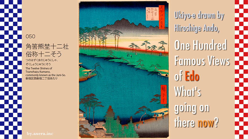
The painting "The Twelve Shrines of Tsunohazu Kumano, commonly known as the Juni-So" is a view from above Kumano Shrine in present-day Nishi-Shinjuku, looking down on Benten Pond, which used to be on the west side of the shrine.
First of all, please look at the map to see where this painting was drawn.
The view is probably looking south from above Kumano Shrine in present-day Nishi-Shinjuku.
Now let's take a closer look at Hiroshige's painting.
At the top of the painting, there is a blackish mountain. Some say it is Mt. Oyama, but I think it is probably the area around the NTT building at the current intersection of Yamate Street and Hatsudai, which was a thick forest at the time.
Below it are several pine trees, and to the right of them is a stone monument inscribed with the origin of the twelve shrines. This has now been moved to the precincts of Kumano Shrine. Underneath the green grass is a large pond, with a kind of pier set up. There seems to have been a small waterfall to the left of the pond, next to the shrine, though it is not visible.
At the bottom of the painting is an earthen mound that stops the water from flowing into the pond, with a pier above it and the shrine of Kumano Shrine on the left.
Kumano Shrine was built in the Onei era by Kuro Suzuki, a merchant from Kishu in the Muromachi era, who was called Nakano Chosha. Guro Suzuki made his fortune by cultivating the area between present-day Nakano-sakaue and Nishi-Shinjuku and trading horses. Initially, he enshrined Nyakuichi-oji of Kumano Sanzan, his hometown, but his business was so successful that he later started to enshrine all the Twelve Gongen from Kumano Sanzan. This is where the area came to be known as the "Twelve Shrines" or "Juniso.
In the Edo period, the river was dammed to create Benten Pond on the west side of the shrine, and a small waterfall was created on the northeast side of the shrine.
Hiroshige depicted the same place in a horizontal position in his "Inside Edo Sights".
By this time, the area was a scenic spot near Edo, and the surrounding area was lined with teahouses and ryotei (traditional Japanese restaurants), eventually becoming a red light district. At its peak, the area was said to have about 100 teahouses and ryotei restaurants. According to the records of the literati, the area was actually crowded until after World War II.
In order to find out where the Benten Pond in the painting was located, I tried to find it on an old map. First of all, I found the description of "pond" on a map from the early Meiji era. There is a torii gate beside it, so this is the Kumano Shrine. I added a red gradation to represent Hiroshige's viewpoint.
Next, I discovered a pond in an aerial photo taken around 1947. This photo is available on the web from the Geospatial Information Authority of Japan.
Furthermore, in 1963, the size of the pond was reduced by about half.
By 1975, it had completely disappeared from the scene.
I took the trouble to put a modern photo over it. There is not even a trace of the pond left.
I reverted to the current map.
I also looked for an old map here. This is an old map from the Tenpo period. The shrine on the far left is Kumano Shrine, the road on the north side is Ome Kaido, the road on the south side is Koshu Kaido, and the waterway underneath is Tamagawa Josui. The area between these two ways is called Tsunohazumura, and the two ways intersect eastward at Oiwake, the area where Isetan is now located.
I prepared a more accurate map of the area. I also plotted landmarks on it so that you can see how it relates to the present.
This shows that Benten Pond is a pond for agricultural water, created by drawing water from the canal connecting Tamagawa Josui and Kanda Josui waterways and holding it back.
I actually visited this place.
This is the place where the viewpoint is supposed to be. Hiroshige may have painted this view from about 15 meters above the ground.
I moved forward a little more to where I could see in front of me. Assuming that you are looking at Benten Pond from the top of the current pedestrian bridge, you will get this picture.
This is the Kumano Shrine as it looks today. The direction of the shrine seems to be the same as when Hiroshige painted it.
I turned the camera from the entrance, which you enter from the Benten Pond side.
A monument inscribed with the origin of the twelve shrines in the painting was located in the precincts of Kumano Shrine.
This picture is around the far side of Benten Pond. You can see the large depression.
Here is a picture looking toward the pond from the area where the earthen mound that held the water of Benten Pond used to be. There is now a road in the middle.
Here, I found an old ginkgo tree standing quietly in the gap between buildings. It had been driven out by the buildings, and although the branches had been cut down drastically, it was still bearing healthy leaves. This tree has probably been here for a long time, and has been closely watching the transition of Benten Pond and its surroundings. It makes me feel a little sad to think about it.
I tried to fit a current photo into Hiroshige's painting. There is not a trace of what it looked like back then.
This is what it looks like now, but I tried to fit in Applemap's Street View, which has a higher perspective and includes Kumano Shrine.
This is a major tourist spot that was very crowded until just before the Showa period. It was a landmark of the area where Benten Pond was built, tea stores were built along its shores, and it developed into a town lined with restaurants and even a brothel about 80 years ago. I would like to interview that old gingko tree and ask, "Would you please tell me about the old days?
