
I visited the actual location of my favourite 100 Famous Views of Edo, painted by Ando Hiroshige, to see how the scene looks today.
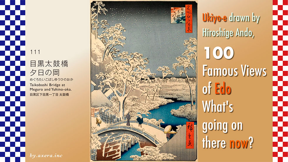
111, "Taikobashi Bridge at Meguro and Yuhino-oka", depicts a bridge over the Meguro River, down a steep hill from present-day Meguro Station.
Please check where that is located on the wide-area map first. The main stage of this project will be a small bridge located exactly 2 ri, or 8 km south-south-west of Edo Castle.
See enlarged map. If you continue along Meguro-dori, the main street that crosses Meguro Station, you will gently turn down Gonnosuke-zaka and cross the Meguro River at Meguro Shinbashi bridge, beyond which, on the left corner of Yamate-dori, you will find Otori Shrine, famous for its rake fair. The Taiko-bashi Bridge, the setting of the present painting, is another bridge downstream from this Meguro Shinbashi Bridge. The perspective of Hiroshige's painting has a red gradient.
This is covered by a pictorial map of the time. However, the locations and scale do not match, except at the drum bridge point, so please see this for reference only.
Next, please see the GSI map with the exact location. Cover it with the map of that time by JHICO MAP. Please enjoy a short historical walk here.
The road from Shirokane Imazato-mura, the predecessor of today's Meguro Dori, heading south-west crosses the man-made river, Mita-Yosui, on its way. Just at this point is the present-day Meguro Station. Now, if you follow the road, you will go down the gentle Gonnosuke-zaka slope, but immediately after passing the station, the road cranks slightly to the left and goes down the steep Gyonin-zaka slope. Before the new Gonnosuke-zaka was opened in the Edo period, this slope was an important road, known as Futago-michi, leading from Edo City to Meguro-suji. This is indicated by the blue dotted line.
Around the first half of the 17th century, a gyoja from Yudonosan, one of the three mountains of Dewa, built the Dainichi Nyorai Hall and began ascetic practices, which gradually attracted many gyojin to live there, hence the name Gyoninzaka. As soon as you start to descend the slope, Daienji Temple, where this Dainichi Nyorai Hall is located, appears on the left.
Daenji Temple was also the site of the Great Meiwa Fire, one of the three major fires of the Edo period, which spread 24 km from here, killed 15 000 people and destroyed Nihonbashi and Ueno. The fire was also known as the Meguro Gyoinzaka Fire, as it was caused by the arson of Daienji Temple by a monk from Kumagaya Mujuku in Bushu. In memory of the victims of this fire, Daenji built a stone statue of 500 arhats, which remains to this day.
The Daenji temple is also home to the tombs of Oshichi Yaoya (grocer) and his lover Kichisaburo.
The 16-year-old daughter of a grocer in Hongo, Edo, was burnt out in the Great Tenwa Fire of 1683 and took refuge with her parents at a temple, where she fell in love with Kichisaburo, a young priest of the temple of the same age. Eventually, the shop is rebuilt and the family returns, but Oshichi's feelings for Kichisaburo only grow stronger. Thinking that if his house burned down again, she would be able to live at the temple with Kichisaburo again, she sets fire to her house with the sole intention of seeing him again. Although the fire was quickly extinguished and only a small blaze broke out, Oshichi was caught for arson and was sent to the Suzugamori Penitentiary where she was burnt at the stake.
It is not known if this story is true, but Ihara Saikaku turned it into a story as Koshoku Gonin Onna (The Five Women of Good Colour), which became a big hit in joruri, kabuki and theatrical performances. Kichisaburo later became an ordained priest and took refuge in Myo-Ouin Temple, which was located below the Daenji temple, to make a memorial service for the spirit of Oshichi. It is said that Kichisaburo changed his name to Saiun and made a vow to visit Meguro Fudo and Asakusa Kannon for 10,000 days, making the 40 km round trip, rain or shine, chanting the Buddhist prayer.
At the entrance to Meguro Gajoen, after descending Gyoninzaka, there is still a well where Saion performed a water purification ceremony to pray for the repose of the Well of Oshichi before going on his Buddhist pilgrimage.
Further along Gyoninzaka, there is a Taikobashi bridge over the Meguro River.
The Edo Meisho Zue gives a good idea of the location of the Daienji Temple, Myo-Oin Temple and the Taikobashi Bridge.
Crossing the Taikobashi Bridge, at the end of the road, to the right was Otori Shrine and to the left Meguro Fudo. This Gyoninzaka and the Taikobashi Bridge were pilgrimage roads for Edo citizens.
The Taikobashi Bridge in the Edo Meisho Zue shows the bridge in great detail. You can see that it was a magnificent bridge built firmly with masonry. Only the roof of the teahouse Shogatsuya on the left side of this painting is also depicted in Hiroshige's painting.
There are various theories as to who built this Taikobashi bridge, but it is said that Saion Shonin, who was ordained by Kichisaburo, the lover of Oshichi Yaoya, built the bridge after collecting donations from the people of Edo during his ascetic training. A sign with the legend of Kichisaburo was placed at the Daienji temple on the east side of the bridge, and the stone used for the Taikobashi bridge is said to have been placed there.
The first stone arch bridge in Japan was the Megane Bridge in Nagasaki. It is said to have been built by a monk who came to Japan from China and became the second abbot of Kofuku-ji Temple. It is said that Saiun Shonin travelled all the way to Nagasaki to learn the techniques used to build the Megane Bridge and built this bridge, but this too is not known for certain. However, looking at the structure, it is very similar.
Now let's take a closer look at Hiroshige's painting.
The overgrown mountain on the left was Myo-Oin Temple at the time, and the whole area was called "Yuhino-Oka", a famous scenic spot acclaimed for the beautiful autumn leaves in the grove that shone in the setting sun. Hiroshige depicted it as a snow scene with peony snow falling quietly from the dark sky.
The blue stream running to the far end is the Meguro River, which, unlike today, meanders onwards and flows almost entirely through the wilderness to Shinagawa-juku.
Go left over the Taikobashi Bridge, which is crossed by people wearing snow-covered umbrellas and Sugasa, and you will go up Gyoinzaka, a steep slope. The private house on the right, with only its roof visible, is thought to be the 'Shogatsuya' teahouse selling shiruko mochi (sweet red bean paste cake), as depicted in the Edo Meisho Zue.
I have actually been here.
This is the view from what is probably Hiroshige's point of view. Ahead in front is Meguro Gajoen and the white building is Arco Tower, which was built in the garden of Gajoen. The Taikobashi bridge that Hiroshige painted was washed away by torrential rain on 1 September 1920, and has been replaced by a new, flat bridge.
This is the view from the current Taiko Bridge looking downstream towards the Meguro River.
This is a view from the current Taikobashi Bridge looking upstream towards the Meguro Shinbashi Bridge on the Meguro River. The area beyond Nakameguro Station is now a popular cherry blossom viewing spot, visited by many tourists in spring.
I tried to fit the current image into Hiroshige's painting.
The angle is a little low, but I wonder if it retains its former appearance. The bridge is now a flat bridge named Taiko-bashi.
It is not known to this day whether the original story of Oshichi Yaoya was an actual event. There is also no proof that the bridge was built by Saiun, who is said to have been a former lover - did Saiun, who visited Asakusa for nearly 30 years to mourn, really travel to Nagasaki to learn how to build bridges?
However, the Taikobashi Bridge was a well-known bridge that actually existed here in Hiroshige's time.
This snowy, snowy winter sky tells us something about it.
I visited the location of one of my favorite "100 Famous Views of Edo" painted by Hiroshige Ando to see what the scene looks like today.
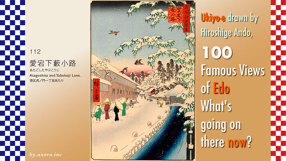
Atagoshita and Yabukoji Lane in #112 is a view looking toward Zojoji Temple from the front of Osakaya Sunaba, a soba noodle shop located at the intersection of Atago Shita Dori and Karasumori Dori.
Please see from the wide-area map which area it is.
It is located in the Toranomon business district, south of the Imperial Palace. The red dashed line is the area.
Please see the enlarged map. I added Hiroshige's viewpoint in red gradient. The blue street running vertically is Atago Shita-dori, and the green streets running left and right are Karasumori-dori. Hiroshige painted from this intersection, looking in the direction of Zojoji Temple.
I covered this with a map of the time. You can see that the streets of the Edo period still remain to some extent today, although they are somewhat out of alignment. On this map, samurai residences are drawn in white, shrines and temples in red, and the areas where townspeople lived in gray. You can also see that this area was all samurai residences.
Immediately to the right of the viewpoint was the residence of the Kato family of the Omi Minaguchi clan, and beyond that were about 13 samurai residences. To the left of the viewpoint were the residences of the Hijikata family of the Ise Komono clan and the Tamura family of the Mutsu Ichinoseki clan, and beyond them were several more samurai residences.
The paths on either side of the street were called Yabu-koji on the Kato family side and Sakuma-koji on the Hijikata family side.
On the west side of the path running vertically is a thin, light blue river, which was drawn from the outer moat, called Sakuragawa at the time, and used as a moat divider.
From the viewpoint, beyond the Tamura family's mansion on the left, there is a small alley to the left. This light blue alley is called Tamura-koji, and the Tamura family's main residence was also located on the right side of the exit from Shinbashi Station. Asano Takumi-no-kami, famous for the Chushingura story, was forced to commit seppuku (ritual suicide) in the garden of the Tamura family's main residence at around 7 p.m. on the day of the riot. It is said that he failed to intervene and cut off his head twice, causing blood to splash all over the garden.
As can be seen by returning to the modern map, the Kato family mansion became Toranomon Hills Business Tower, and the 13 samurai residences beyond it became Toranomon Hills. This mass of samurai residences on either side became Loop Road 2, also known as Shintora-dori or MacArthur-dori.
The Loop Road 2, represented by the blue dotted line, was originally called MacArthur Street, as it was requested by the U.S. occupation forces after the war to build a road from the U.S. Embassy to Takeshiba Pier. In reality, however, this urban planning road had already been planned by Tokyo Mayor Shinpei Goto and others after the Great Kanto Earthquake of 1923.
Subsequently, the project was put on hold due to difficulties in acquiring land for the project.
The redevelopment project was finally resumed when a 1989 amendment to the law made it possible to build on the road, and the above-ground and below-ground portions of the project opened simultaneously in March 2014.
Toranomon Hills was opened by Mori Building in June 2014, covering the entrance to the Loop Road 2 tunnel.
Let us return the map to Edo. The location of the Hijikata family on the left side of the viewpoint is now occupied by Kowa's Nishi-Shinbashi Building. The Shinpukuji Temple at the end of the viewpoint is housed in a magnificent building. The Enpukuji temple beyond the viewpoint was the administrative temple for Atago Shrine, but now only the shrine remains and Enpukuji itself has disappeared.
Please see another pictorial map with Hiroshige's point of view for an interesting comparison with the present. Seishoji Temple at the end of Mt. Atago was partially turned into the two-building Atago Green Hills, but the temple still exists today.
The path leads to the hojo, or monks' residence, of Zojoji Temple. A little further on was the Onarimon Gate, through which the Shogun's family passed when they visited Zojoji Temple. The Onarimon gate has been moved a little, but it still remains today. At the end of the street, the hojo of Zojoji Temple has been transformed into the Tokyo Prince Hotel.
Now we will actually take a closer look at Hiroshige's painting.
The heavy-looking bamboo thicket with snow on it is coming from the right side of the winter sky. It was called "Yabu Kato" because the bamboo thicket was located at the northeast corner of the mansion.
The small mountain at the far end is Mt. Atago, where NHK's transmitting station was located when the station began operations. Just below it, you can see the red gate of Shinpukuji Temple. Three sparrows are flying in the sky. The large building on the left with snow on its roof is the residence of Hijikata Bichu-no-kami, whose entrance, which is said to have been at the front left, is obscured. In front of it is a group of passersby with snow on their green coat. Beyond this, even a small white dog is depicted, which is typical of Hiroshige.
To the right is the Sakuragawa moat, which curves to the left, but not as far as it actually goes. The building that covers the Sakuragawa moat is the Guard station, which was located on the southeast corner of the Kato house. The entrance to the Kato family was located to the right of this Guard station. The Yabu Koji itself is not depicted in this painting, as Hiroshige's perspective is from the bridge over the Yabu Koji in the foreground.
I have actually seen with my own eyes what this place looks like now.
This is the current photo taken from a slightly lower position than Hiroshige's viewpoint. The Sakuragawa moat has disappeared and the width of the street has become much wider. In the lower right is the pedestrian crossing over Karasumori-dori, or the entrance to Yabu Koji at that time.
The building with several canopies on the right is Toranomon Hills Business Tower, which stands at the location of the former Kato family, Toranomon Hills is beyond it, and the two buildings on the other side in the middle are Atago Green Hills on either side of Seishoji Temple.
This photo is a view of Yabu Koji. The left side is Toranomon Hills Business Tower, the former residence of the Kato family, and the wooden house on the right side is Osakaya Sunaba, which was still under construction for house relocation at that time.
I tried to fit the current view into Hiroshige's painting. Well, it is indescribable, the tremendous change. Where have all the samurai residences gone?
Please also see the aerial view of this area. The blue line is Atago Shita-dori, and the green line is Yabukoji, now Karasumori-dori. I also included the red gradient, Hiroshige's point of view. You can see what kind of buildings Toranomon Hills and Toranomon Hills Business Tower are too.
In particular, this Toranomon and Kamiyacho neighborhood is home not only to Toranomon Hills, but also to a forest of Mori buildings, both small and large. Originally, the City Planning Law and the Building Standards Law were supposed to provide for good urban development, but these laws have been amended after amendment after amendment to reach the current state.
In particular, the shading regulations enacted in 1977 restrained the construction of tall buildings to some extent. Later, however, the Building Council of the Ministry of Land, Infrastructure, Transport, and Tourism began to revise and abolish these restrictions, and zoning was also revised. Eventually, the legal system was such that high-rise buildings could be constructed everywhere, as is the case today.
It was a laughable fact that Recruit Co., Ltd. and Mori Building Co., Ltd. which were then involved in high-rise buildings and condominiums, were members of the MLIT Building Council.
This is Osakaya Sunaba, a buckwheat noodle shop that was house relocation at the time of this visit. This iconic building, which stands quietly in the shadow of the building, was built in 1923 and is now designated as a registered tangible cultural property, having survived the war and earthquake.
Tall buildings are fine, but couldn't the city have been built with a little more sunlight and a little more space for human life? Looking at Hiroshige's paintings, I wonder about such things.
I visited the actual location to see how the scene, one of my favorite 100 Famous Views of Edo painted by Hiroshige Ando, looks today.
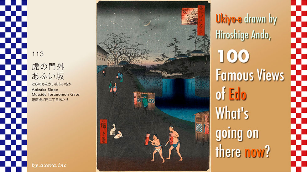
The "Aoizaka Slope Outside Toranomon Gate" 113 is a painting of a waterfall on Sotobori Street by the side of the present-day Kasumigaseki Building, seen from the bottom of the hill.
But those who know what they are talking about will tell you that there are no hills or waterfalls in that area, so please take a look at the wide-area map first. The location of this event is indicated by the red dotted line. It is about halfway between Akasaka-mitsuke station and Shinbashi station.
Next, please see a slightly more enlarged map. I added Hiroshige's viewpoint to this in red gradient. This is the view from Kotohira-jinja Shrine near Toranomon Station, looking just in the direction of the Patent Office building.
This is covered by a map of the time.
When Hiroshige painted this picture, the area from here to Akasaka-mitsuke was a large gourd-shaped reservoir. The pond was so large that the present Sotobori Street was almost completely covered by it.
Replace the display caption on the map.
There was a weir about next to what is now the Kasumigaseki Building, and the water from the reservoir was just like a small waterfall where it overflowed into the Sotobori moat. This was not called "Aoi no Taki" (hollyhock waterfall) by the common people of Edo at that time, but called it "Dondon" because the water was falling rapidly.
The steep hill beside it is Aoizaka, which is indicated by the blue line on the map. The upper left corner of this line is the residence of the Kano family, the feudal lord of Owari Ichinomiya, and directly across from it was a Tsuji-banjo. The Tsuji-bansho was located directly across from the Guard station, and this slope was named "Aoizaka" (hollyhock slope) because hollyhocks were planted there.
On the right side of the line is the residence of Kyogoku Sado-no-kami of the Sanuki Marugame domain, and on the west side of the residence is the Kotohira-jinja Shrine, which was enshrined and became a popular place to make wishes. This "Kompira-san" still exists today, although it is surrounded by tall buildings.
Let's actually take a closer look at Hiroshige's painting.
A crescent moon is floating in the cold winter sky with stars fluttering in the sky, and geese are flying in a line in the shape of the letter "S". On the other side of the waterfall in the upper right is the residence of the Naito family of the Echigo Murakami domain, which was located around the current Patent Office. At the end of the slope on the left, you can see the Guard station where hollyhocks were planted, and to the left is the residence of the Kano family, the feudal lord of the Ichinomiya clan in Owari. If you turn left at this point, you will come to a bank, which is now the U.S. Embassy.
At the top of Aoizaka slope, there was a large old tree called "Shirushi no Enoki. It means a memorial tree of hackberry.This tree was planted to commemorate the creation of a reservoir and weir, and was one of the most famous landmarks in the area.
The water from the weir was constantly flowing down noisily. On Aoizaka slope, samurai and townspeople are also depicted, holding red lanterns in their hands. In those days, there were no lights in the streets, so lanterns were a necessity for the night. In the middle of the hill, you can see a man carrying a buckwheat noodle cart and a cart with "Taihei-shippoku" written on it. This was udon noodles served in Taihei bowls and garnished with ingredients in imitation of Nagasaki's Shippoku cuisine. It was apparently popular at the time, but has since fallen into disuse.
The duo in the very front, barefoot and bareheaded in spite of winter, holding lanterns, are craftsmen who came for the cold work, as "Konpira Daigongen" and "Nissan" are written on the lanterns. Craftsmen who were still in indentured servitude came to visit the shrine every day for 30 days from Risshun to Setsubun, so that they could improve their skills. After finishing their work, they would come to the Kotohira-jinja Shrine at dusk in loincloths, carrying lanterns and ringing bells.
The two dogs, ignoring them with a blank expression, are also giving off a nice flavor.
Hiroshige depicted this Aoizaka slope in almost the same composition in his picture book Edo Souvenir.
This one also depicts the bustle of "Kompira-san" and other activities in the foreground. Memorial tree of hackberry on the hilltop is emphasized.
This is the same composition, a little brighter, and depicts Kootohira-jinja Shrine in front of Aoizaka slope.
These are all paintings of Aoizaka slope by Hiroshige II, from slightly different angles.
Katsushika Hokusai also painted Aoi no Taki as a subject. In particular, the Guard station at the back of the waterfall is depicted very clearly. The way Hokusai painted the surface of the pond, the part of the waterfall where the water falls, and the surface of the water flowing after the waterfall, is indeed Hokusai's work.
I actually went to this location. This is what the picture looks like from Hiroshige's point of view, which is quite accurate. Aoizaka slope in Hiroshige's time is now almost the location of the Mitsui O.S.K. Lines head office building, and from the viewpoint of the Kotohira-jinja Shrine, only the entrance to the parking lot can be seen.
So I took a slightly removed photo. On the left is the MOL head office building, on the far right is the Patent Office, and to the right is the Tokyo Club building. You can see the blue traffic sign for the bus lane in the middle of the photo, but it is thought that the slope was higher at that time.
This photo was taken from a pedestrian bridge, but the weir was probably higher than this.
To match the atmosphere, I inserted Hiroshige's painting into this one. How do you like it?
I actually tried to fit the current view into Hiroshige's painting.
I also tried to fit in a night view. However, since there are no hills or waterfalls in either case, there is an indescribable sense of discomfort.
The Akasaka reservoir was a man-made lake built around 1606 by Yukinaga Asano of the Wakayama domain as part of the outer moat for defending Edo Castle and as a drinking water dam. About 15 years after Hiroshige painted this picture, the reservoir was converted into a tidal flat, the stone wall that had served as a weir was removed, and the hill called Aoizaka was cut down and the soil was used to fill the reservoir. After that, it became a road, then a house, then a building, and the era changed the town more and more like the sound of a waterfall "dondon".
Now, the reservoir, the waterfall, and the Aoizaka slope are unimaginable, they have become illusions.
I visited the actual location of my favourite painting by Hiroshige Ando, One hundred Famous Views of Edo, to see what the scene looks like today.
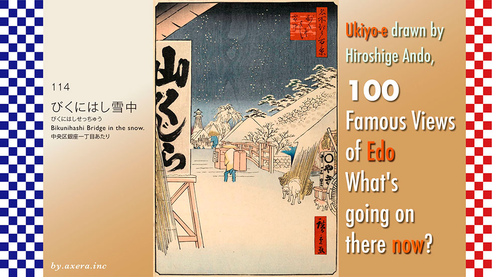
The 114 'Bikunihashi Bridge in the snow' is a view looking towards Sukiyabashi from around Ginza 1-chome on what is now Sotobori-dori Street.
Many people think of Ebisu or Oizumi when they think of the Bikunibashi Bridge, but first look at a wide-area map. It's about just southeast of the Imperial Palace. I've surrounded the general location with a red dotted line.
See a slightly enlarged map. I added Hiroshige's viewpoint to this with a red gradient.
After exiting Tokyo Station from the Yaesu Exit, go to the right and head south on Sotobori Dori, passing under the Expressway just beyond the Kajibashi intersection. This is the view from a standstill just before that point.
This is overlaid with two maps of the time connected together.
This map shows the moats in dark blue, the daimyo's residences in white and the townspeople's houses in grey. On the left side are all the daimyo's residences, and at the back left of this area was Edo Castle. So this area was called Daimyo Koji. This is the group of buildings up to the inner moat, starting from what is now the Tokyo Forum.
Within this daimyo alley, you can see many large residences of the Matsudaira family. This was because the shogunate sent its trusted vassals to live close to Edo Castle.
The bikunibashi bridge of the title was a small bridge over the Kyobashi River, where it parted from the Sotobori moat. These bigaunis were private prostitutes dressed as nuns, and there were many unauthorised prostitutes' residences in Kitakonyamachi to the north and Nishikonyamachi to the south of the Kyobashi River.
Also, as you can actually see from the map, one side of the wide road was the Sotobori moat, and beyond that there were only vast daimyo residences, so it is undeniable that this place was a bit lonely.
Three more red circles are plotted. The red circle on the right is the location of the residence where Hiroshige lived at the time. It was on the south side of the current Artison Museum, in the immediate neighbourhood of the Bikunibashi Bridge.
Furthermore, the red circle on the left, where Meiji Seimei is now located, was the residence of the firefighters where Hiroshige was born and raised. On the north side of Sukiyabashi Bridge, behind the current police box, was the Minamimachi Magistrate's Office, famous for Ooka Echizen.
In addition, the moats, painted in dark blue, are large and prominent, many of which are now Expressway. This is indicated by the green line. This is because the quickest and cheapest way to get to Tokyo in time for the 1964 Olympics was to make effective use of the moats that still existed at the time.
Let me turn the map back to a modern map here. It's a bit painful, isn't it?
Let's take a closer look at Hiroshige's painting.
The fire watchtower at the Sukiyabashi Gate can be seen on the other side of the dark sky with snow falling. It seems to have been located just around the entrance to the present-day Yurakucho Marion.
The shop with the eaves overhanging from the left and the sign 'Yamakujira' written on it is an Owari-ya, or Momonji-ya. Momonjiya were shops in farming villages near Edo during this period that fed and sold meat such as wild boar and deer captured by farmers and hunters.
Momonjiya still remains today, across the Ryogoku Bridge, doesn't it? This is so-called gibier cuisine. Since the arrival of Buddhism, four-footed animals have been frowned upon and rarely eaten. However, from around the middle of the Edo period, it began to be eaten under the pretext of "kusuri-gui" (medicine eating) to restore strength after illness, and by Hiroshige's time it had become a common taste among the general public. In fact, at Owariya, wild boar and spring onions were boiled in a pot and served. This is the so-called "Shishi-nabe.
The man carrying the luggage, about to cross the bridge, is an oden shop, which appears to have hot sake heated in a brazier on the menu. To the right, the shop with the sign '○yaki 13-ri' is a baked sweet potato shop. The name was a pun on 'better than chestnuts' and meant '13 ri', a combination of 9 and 4 ri.
This is because 1 ri is approximately 4 km.
Also, if you actually come from Kawagoe, a major producer of sweet potatoes, to Nihonbashi via the Shinkagishi and Sumida Rivers, it is just about 52 km, so it is possible that "13ri" was a cloaked term meaning Kawagoe or sweet potato.
I have actually been to this location.
This is the view from where I stood on the north side of the present-day site of the Bikunibashi Bridge. Of course, there is no bridge and the Metropolitan Expressway, which was built by crushing the Kyobashi River, has largely covered the area from above. The Sotobori moat on the right has also become an Expressway, with various shops underneath. The road itself has also been greatly expanded and is now a six-lane Sotobori road.
Here, watch the video to see how the Expressway is heavily covered.
See also the video with the viewpoint swung from the left to the right. There is no Momonjiya on the left side, and as the viewpoint is swung to the right, the moat is covered by the Metropolitan Expressway and the former Daimyo Alley is now a building and bus terminal.
This is the picture I took as I went through the Metropolitan Expressway. The dark blue glass building almost directly in front is Tokyu Plaza, on the other side of Sukiyabashi Crossing.
The white building at the very front on the right is the Kotsu Kaikan, and the Minami-machi Magistrate's Office used to be located beyond it, around the end of the building containing Itocia and Marui.
This is a photograph of the same location from a book published in 1919. According to the article, both the momonji shop on the left, Owariya, and the sweet potato shop opposite, existed at this time. However, it seems that the management had been replaced.
This is a photo from the Yurakubashi traffic lights looking towards the direction of the now absent, no longer existing, Bikunibashi Bridge. The road has been widened considerably on this Sotobori Dori, so it is thought that the Bikunibashi Bridge at that time was located right under the front Metropolitan Expressway, around the yellow triangle.
I tried to fit the current view into Hiroshige's painting. The oppressive and uncomfortable feeling of the Metropolitan Expressway from above is indescribable.
Using the generation AI, I also inserted an image of a real landscape as a winter landscape. Did it bring the atmosphere a little closer?
Now, in fact, this painting was positioned before one of the final works in the series and was actually issued after Hiroshige's death. For this reason, there are many researchers who argue that it may have been painted by Hiroshige II.
Although I do not know the truth of this, I think it is an excellent work that fully demonstrates Hiroshige's style in its overall composition, the way the oden shop man is depicted and the cute dog that also appears.
I visited the actual location to see what the scene looks like today in my favourite 100 Famous Views of Edo painted by Hiroshige Ando.
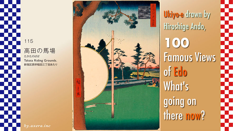
The 115 'Takata no Baba'(Takata Riding Grounds) is a view looking towards Mt Fuji from a stable near the current Nishiwaseda intersection.
First, please look at a wide-area map to see where this 'Takata no Baba' was located. It is on the east side of the city, about halfway between Ikebukuro and Shinjuku stations.
The location is surrounded by a red dotted line.
Please see a slightly enlarged map. The position where this Takata no Baba was located is painted in green. This way you can see that Takadanobaba Station and 'Takata-no-Baba' are quite far apart.
On this map, I have taken into account the direction in which Mount Fuji is depicted in Hiroshige's painting, and I have used a red gradation to represent his point of view.
The Takata no Baba was built in 1636 by the third Tokugawa Shogun, Iemitsu, for the training of his banners in horsemanship and the dedication of yabusame archery. It is said that the name Takata-no-Baba was taken from the name of Takata, as this area was the pleasure grounds of Takata-dono. Takata-dono refers to the mother who gave birth to Tokugawa Ieyasu's sixth son, Matsudaira Tadateru, who later became the lord of the Echigo Takata domain.
How did Takadanobaba Station and Takata no Baba come to be so far apart?
We have covered the current GSI map with a map from 1881, when there was still no railway service.
In 1910, when a station was to open on the Yamanote Line, the locals requested the name of the station as "Kamitotsuka" and "Suwanomori", which was the name of the location. However, the Railway Board did not adopt them, but instead adopted the name of a historical site, Takatanobaba, about 1 km away from the station, as the name of the station, which read "Takada-no-Baba".
The writer Nagai Kafu, who was born in Koishikawa, Tokyo, wrote in his masterpiece of modern historical material, Dancho Tei Nichijou, as follows.
He commented that the reason why Akibagahara was read as 'Akihabara' and Takata-no-baba as 'Takada no Baba' was probably because many officials of the Ministry of Railways were country people who were not familiar with the names of places in Tokyo.
I have heard a similar story in the Takanawa area just recently.
The historical site of Takata-no-Baba, which gave the station its name, is not the horse riding stable for training, as depicted by Hiroshige. It was the scene of one of the Chushingura stories, the 'Takata no Baba no Ketto' (Duel in Takata Baba).
On the northern side of Takata-no-Baba, the Mizuinari Shrine still stands, and a monument in honour of Horibe Yasubei, who played a leading role in the Takata-no-Baba Duel, can still be seen on the approach to the shrine.
The Takata no Baba no Ketto was a duel that took place in the 7th year of the Genroku era between the feudal warriors of the Saijo clan in Iyo Province. One of the clan members, who knew in advance that he was outnumbered, went to Nakayama Yasubei, a pupil of the same Horiuchi Dojo, prepared to die, and asked him to deal with the situation. However, Yasubei eventually decided to assist this clan member.
As a result, Yasubei killed three of his opponents and made a name for himself as a great swordsman, and Horibe Kanemaru, an Ako clan member, heard of his reputation and decided to take Yasubei as his son-in-law. Seven years later, the Ako Incident occurred and Yasubei, who had been adopted, was forced to commit seppuku as a ronin who participated in the raid.
This incident became the subject of a play called Chushingura, which was performed in ningyo joruri and kabuki and was a big hit in Edo at the time.
Later, Satcho, who successfully carried out a coup d'état by carrying the Emperor, promoted the Meiji Restoration, and after the Russo-Japanese War in 1905, as nationalist ideology was on the rise, the government began to reevaluate the loyalty of the loyal subjects who gave up their lives in Chushingura, and the government began to take advantage of this. The time when the name of Takadanobaba station was decided was just at the height of this trend.
Let us take a closer look at the Takata-no-Baba painted by Hiroshige.
The pine tree occupying the left side of the picture is a pine tree on the north side of the stable to protect it from the wind. Fuji is depicted in the center of the painting, but the snow accumulation is ambiguous. This painting was originally published as a winter painting, but considering the yellow color of the rice paddies, it may have been an autumn painting that was hastily changed to a winter painting.
Anahachiman, a shrine dedicated to the patron god of archery, is located in the immediate neighborhood, and successive shoguns used to dedicate yabusame horseback archery rituals to pray for the safety of the nation. This painting seems to depict just in the middle of the ceremony. The large white circle is the target of yabusame and was covered with leather. The arrowheads were covered with cloth to prevent the target from being torn. The arrow that hit the target and fell is depicted below the target.
It is recorded that the 8th Shogun, Yoshimune Tokugawa, dedicated yabusame to Anahachiman to pray for the cure of pemphigus, which was prevalent at that time.
I have actually been to this location.
The stable is gone and the area is completely residential. On the right side of the photo is a street running north of the former stable, called Chayamachi-dori because many spectators came to watch the dressage training and local farmers opened teahouses.
This is a view from the Nishiwaseda intersection looking at what used to be Baba. On the left is the street on the south side of Baba, now Waseda Street, and the alley on the right is Chayamachi Street on the north side of Baba.
This is the entrance to Ana Hachimangu Shrine seen from Babashita-cho. In the Edo period, the shrine was famous for its prayers for a charm to cure children's tantrums. Yabusame, which used to be held in Takatanobaba, is now held every year on October Sports Day in Toyama Park on the south side of the shrine. Today, the shrine is famous for its "Ichiyo Raifuku Omamori", and on the day of the winter solstice, worshippers line up in front of the shrine from dawn to see it.
I tried to fit the current view into Hiroshige's painting. The area that used to be a horse stable is now lined with houses, so you can't see all the way to the other side. This area was on a hill, and it is said that Mt.fuji.
In those days when there was little entertainment, Yabusame, visits to Anahachiman, and pilgrim-like visits to the sacred site of "Takatanobaba no Ketto" duel brought more vitality to this area than we could have imagined.
In June 1975, even the addresses around the station were changed from Totsuka-cho and Suwa-cho to Takadanobaba for Takadanobaba Station, which was named to reflect the government's intentions at the time. As a result, the meaning of the word "Takadanobaba's" has completely changed.
Hiroshige probably did not think of it, but the times added various side streets to this painting.
As a side note, Lord Takada was born in the Echigo Takata clan, famous for its cherry blossoms, and Horibe Yasubei was also born in the Echigo Shibata clan, famous for its cherry blossoms. There is also a place named Takada in that Shibata City.
Of the 47 Ronin who participated in the Chushingura raid, it seems that only Horibe Yasubei had actually killed someone with a sword. This was a smaller side note.
In the rakugo story "Takatanobaba," a gama-no-oil peddler leaves the precincts of Senso-ji temple in Asakusa, saying that a duel will take place tomorrow at Takatanobaba. On the day of the duel, Takatanobaba is said to be crowded with spectators, and the nearby teahouses and stalls become very prosperous.
The story goes that the gama-no-oil peddler was actually paid by local merchants to spread the word that a duel was going to take place at "Takatanobaba.
I visited the actual location to see how the scene, one of my favourite 100 Famous Views of Edo, painted by Hiroshige Ando, looks today.
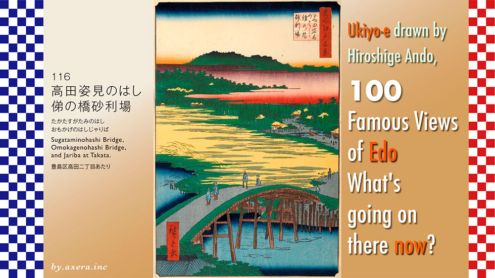
116, 'Sugataminohashi Bridge, Omokagenohashi Bridge, and Jariba at Takata', is a painting looking roughly north from the current Omokagebashi Station on the Toei Arakawa Line.
See its location on the wide-area map. It is located between Ikebukuro and Shinjuku, around the east side of Takadanobaba Station. It is surrounded by a red dotted line.
Next, please see a slightly enlarged map. The Toden Arakawa Line runs south along Meiji-dori from the north, crosses the Kanda River, and turns east on Shin-Mejiro-dori, at the end of which is Omokagebashi Station. Hiroshige seems to have painted the view looking north from about this Omokagebashi station. The viewpoint is represented by the red gradation.
Let me cover this with a map from JHICO MAP. There is still no Shin-Mejiro Street, but there is a road running north-south on the Omokagebashi Bridge, and going north, there is Nanzoin Temple and Hikawajinja Shrine, and after passing there, it becomes a steep slope called Shukuzaka, which crosses the present Mejiro Street. This is represented by the blue line.
Mejiro-dori is a ridge road that runs through the Mejiro Plateau and was called Kiyoto-Michi at that time. Going west, it passed through Ekoda and Yahara, and reached Kiyose. It was an old road that ran almost halfway between today's Kawagoe Kaido and Ome Kaido.
I have enlarged the modern map more and dropped in some elements.
First of all, the Nanzoin site was much larger than it is today, and a moat for rice paddies ran through it. The small bridge over it is the bridge of the figure. It was called Sugatami-no-hashi because the pond into which the water was actually drawn was located right beside it, and when you looked into it, you could see your reflection as if it were a mirror.
Crossing the Sugatami Bridge and going straight north on this blue line of the Shukuzaka slope, you will come across Kishimojin in Zoshigaya. This deity is famous for easy childbirth and child rearing. Further on, the road joins Nakasendo, and one could continue on Kawagoe Kaido. It is still a narrow road, but it was one of the old Kamakura-kaido roads.
The entire north side of Nanzoin was a gravel pit village. I do not know if this is the reason, but there were many very steep slopes.
Starting with the Shukuizaka slope behind Nanzoin Temple, there are Inarizaka and Obusezaka, which are still famous as some of the steepest slopes in Tokyo. Nozoki Slope, which was newly built parallel to the Toden Arakawa Line, is so steep that whenever it snows in Tokyo, the staff who cover the event always come to the area.
Let's take a closer look at Hiroshige's painting.
The bridge over the Kanda River in the foremost foreground is the Omokagebashi Bridge. The yellowish area beyond that is rice paddies, and the lowlands along the Kanda River were mainly used for rice paddies. The moat for this is the small river seen beyond.
Hiroshige painted this picture with reference to Edo Meisho Zue by Hasegawa Settan, but the bridge, the moat, and the Hikawa Shrine are in the opposite positions. Furthermore, it seems that he could not determine which bridge is the title, "Omokage no Hashi" or "Sugatami-no-Hashi".
Looking at the "Sigatami Bridge" section of Edo Meisho Zue, it seems that the large bridge in the left foreground over the Kanda River is "Omokage-no-Hashi" and the bridge on the far right in the neighborhood of Nanzoin is "Sigatami no Hashi. The "Hikawa" mentioned here is the Hikawa Shrine located in Shimo-Ochiai on the upper reaches of the Kanda River.
In Hiroshige's painting, the path is quite winding from the "Omokagebashi Bridge," but in reality it is a very gently winding path. Also, looking at the difference in size between the people crossing the "Omokagebashi Bridge" and those around the "Sugatami-no-Bashi Bridge" at the back, one might think that the distance is quite long, but in reality, the distance is only about 200 meters.
I actually went here.
This is the view from a little behind Hiroshige's point of view. You can't see very far at all.
This is the view from the front of the Omogagebashi Bridge. The road curves a little to the left, so you cannot see all the way to the end.
This is the Hikawajinja Shrine that appears on the left as you go ahead. It was founded around 860 during the Heian period and was first called "Yamabuki no Sato Hikawagu Shrine.
This is the main entrance to Nanzoin, located across from Hikawajinja Shrine. The main deity is Yakushi Nyorai, said to have been founded in the Muromachi period and brought to this area by the Oshu Fujiwara clan.
A monument to Yamabuki no Sato stands in front of an apartment building just to the right of the Omokagebashi Bridge.
The area from Yamabuki-cho to Omokagebashi Bridge in Shinjuku-ku near Edogawabashi Station is commonly known as "Yamabuki no Sato. The name "Yamabuki no Sato" comes from a legend that when Ota Dokan was out hawking and encountered rain, he asked a young farmer's daughter for a straw raincoat, and was offered a branch of Yamabuki.
Ota Dokan was later told that the name "Mino" was a pun on the words "Mino" and "Mino" from an old waka poem, "Nanae Yae Hana ha sakedomo Yamabuki no Mino Hitotsudani Naki zo Kanashiki" is mean though flowers bloom in layers of seven, yet not a single one of them bears a fruit, which is sad. Hearing this, Doukan was ashamed of his illiteracy and devoted himself to waka poems, and since then, he has been known as one of the six poets of the samurai class.
However, the location of this "Yamabuki no Sato" is not certain, as there are other theories that place it in Machiya, Arakawa-ku; Mutsuura, Kanazawa-ku, Yokohama City; and Ogose-cho, Saitama Prefecture.
I actually tried to fit the current picture into Hiroshige's painting, but it turned out to be just a picture of a bridge and a building. I wonder why Hiroshige chose such a place, which he had never even been to, as a famous landmark.
Currently, the Kanda River in this area is protected by a concrete embankment. However, in spring, many cherry trees bloom from both banks of the river, covering the area with their blossoms. The tunnel of cherry blossoms is nothing short of magnificent.
This is a view of the cherry blossoms along the Kanda River looking downstream from the Omokagebashi Bridge.
The Toei Arakawa Line, renamed the "Tokyo Sakura Tram," also makes a great picture when it runs around the Omokagebashi Bridge, combined with the cherry blossoms. This may be the best sightseeing spot involving the Omokagebashi Bridge, now that it is not a yamabuki, a bridge, a temple, or a gravel pit.

I visited the location of my favorite painting by Hiroshige Ando, "One hundred Famous Views of Edo" to see what the scene looks like today.
The 117th picture, "Hilltop View from Yushima Tenjin Shine" is a view looking north-northeast from the east end of Yushima Tenjin Shrine.
Please see from the extensive map. Yushima Tenjin was located about 2 km southwest of Ueno Station. The location is surrounded by a red dotted line.
Next, please see a slightly enlarged map. The red gradient represents Hiroshige's viewpoint. It is difficult to see on the map, but the viewpoint is from the east side of the shrine building, looking toward Shinobazu Pond.
I covered this with a map of the time. You can see that the cut-through on the north side of Yushima Tenjin Shrine, shown in blue, was a road that existed at that time.
Let us first take a closer look at the painting by Hiroshige.
A large pond can be seen under a clear sky where the snow has just stopped. This is Shinobazunoike Pond, which is still famous for its beautiful lotus flowers before summer. When Priest Tenkai was entrusted with the grand design of Kan-eiji Temple in Ueno, he built it in imitation of Lake Biwa, and the red figure in the pond is Benten-do in Nakajima. The red building in the pond is the Benten-do in Nakajima, which was also originally built to resemble Chikubujima Island in Lake Biwa. Two small roofs can be seen behind it, and these are Kan-eiji Temple. In terms of direction, this could be either Toshogu Shrine or the Sanmon Gate of the temple.
The small roof seen at the far end of the pond is the residence of Izuno-kami Okochi of the Mikawa Yoshida clan, which was located at the end of the Aizome River. The many roofs in front of the pond are the town houses of Ikenohata-nakamachi. At that time, the Shinobugawa River flowed in front of these townhouses, and the Shinobazu Pond was located at the end of the bank.
This is also a famous place for snow viewing, so the hooded people coming up the front with their umbrellas squeezed shut are the beautiful people of the Geisha community in the Yushima and Hirokoji neighborhoods. The slope in front of the torii is the gentle Onnazaka Hill, and the slope coming up from the right is the considerably steeper Otokozaka Hill. Both the Onnazaka and Otokozaka slopes are actually much narrower than in this picture.
Hiroshige also depicted the same place in his picture book Edo Souvenir. If you look closely, you will see that Benten-do is depicted about halfway between Onna-zaka and Otoko-zaka. In terms of direction, this is a better fit.
In Hiroshige's painting of Yushima Tenjin at New Year's, Benten-do is also depicted across Onna-zaka.
This is a scene of a snowy day, seen from the east. On the left, you can see what appears to be a ryotei restaurant.
This painting depicts Otokozaka at sunset on a clear day. Here, too, what appears to be a ryotei restaurant is depicted on the left and right.
This painting depicts a view of one of these restaurants. Yushima Shokin-tei, but its location is not known for certain. However, we do know that it was a scenic spot from which one could enjoy a panoramic view of Edo.
The painting on the right was painted by Hiroshige II. The setting here is nighttime, and the painting depicts the area from in front of the main hall toward Otokozaka, where snow is falling. It seems that when it snowed at that time, the standard style was to wear an umbrella, hood, and haori coat, high-toothed geta clogs on the feet, and a hat and straw raincoats for craftsmen such as Botefuri peddler.
I have actually been here.
Looking north from the Onnazaka hill, the Shinobazu Pond depicted in the painting is not visible, and only the white apartment building in front can be seen. The lower view on the right is Otoko-zaka, and the far left is the pillar of the torii gate.
If you go a little further forward, you can see that it is surrounded by buildings like this.
This is a view from in front of the main hall of the Yushima-tenjin shrine, looking toward where the Onnazaka and Otoko-zaka hill meet.
This is the front gate of Yushima Tenjin Shine.
Yushima Tenjin Shine, officially called Yushima Tenmangu Shrine, was built in 458, and in 1355, during the Nanbokucho Period, Sugawara no Michizane was invited to the shrine. This torii gate is a designated cultural property of the Tokyo Metropolitan Government.
This is the main hall. Since the shrine is dedicated to Sugawara no Michizane, the god of learning, it is visited by many students preparing for entrance exams in the fall, and by the end of the year, the shrine grounds are filled with votive tablet for prayers.
In February, the Ume Festival is held and many visitors come to enjoy the long-awaited spring in the precincts of the shrine, where a variety of well-groomed plum trees are in full bloom. The plum blossoms at Yushima Tenjin have been known since the Edo period as a place for flower viewing and have become synonymous with Hanami flower viewing.
This is a photo of Otokozaka as seen from above and from below. Yushima Tenjin stands on the eastern edge of the Hongo Plateau. In other words, as a shrine on a cliff, it has been famous for its view since the Edo period. At that time, from the north, one could see Shinobazunoike Pond, the large temple complex of Kan-eiji Temple, the streets of Hirokoji, a major entertainment district, below, and to the south, Edo Bay and Tsukuda Island in the distance.
I actually tried to fit the current photo into Hiroshige's painting. Sadly, I can't deny the feeling of being buried by buildings.
The main attraction of this Yushima Tenjin was the view from the hill from which one could see all of Edo. Nowadays, however, the view is completely lost and the area is surrounded by buildings. Sugawara no Michizane, who is enshrined here, would never have dreamed of such a situation.
So, I included a plum tree looking up at the blue sky against the background of the main hall, which has a ume-bachi pattern is family crest of Sugawara no Michizane on ridge-end tile. I think this is more like a current Edo landmark.
I visited the actual location of my favourite 100 Famous Views of Edo, painted by Hiroshige Ando, to see what the scene looks like today.
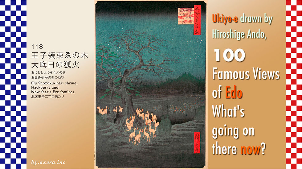
This time 118, 'Oji Shozoku-Inari shrine, Hackberry and New Year's Eve foxfires', is said to be a painting looking at Oji Inari Shrine from around the present-day Kitahon Street, but the detailed location seems to be a little unclear.
First, please check its location on a wide-area map.
The map depicts the famous Enoki tree (Hackberry), which was located around the present-day Oji Station, about 8 km north of Edo Castle.
Next, to help you understand the Oji neighbourhood in the Edo period, please see part of a pictorial map depicting Sugamo at that time. Although not as accurate as a map, it shows the places of interest in the area, centred around the Shakujii River. At that time, the Oji area was a very useful place to visit as a slightly remote sightseeing spot for overnight stays just outside of Edo.
In spring, the cherry blossoms on Asukayama and the view to the east, cherry blossoms and autumn leaves along the Shakujii River, and waterfall viewing and bathing in summer were also popular. There were also many teahouses in the area to entertain guests. If you look closely, you can even see the names of the teahouses on this map, which shows how many Edo citizens visited Oji.
Hiroshige, who loved Oji, published five paintings in this neighbourhood leading up to this 118-view.
Now see enlarged map.
Oji's appeal as a tourist destination was also due to the pilgrimages to this Oji Inari and Oji Shrine.
The Oji Inari Shrine in particular was exceptionally busy, with "horse day" in any lunar every month being a fair day, and a 'kite market' held on the first "horse day" of February. Kites that flew high above the wind, which caused fires to grow bigger, were lined up on the shrine grounds as a fire prevention charm, and many Edo citizens from Edo, where fires were common, visited the shrine to buy these kites.
On this map, I tentatively determined where Hiroshige's viewpoint would have been, and put a thin red gradient where I thought this would be.
Let's take a closer look at Hiroshige's painting.
First of all, this painting is not of an Edo landscape as Hiroshige had previously painted it, but of an old tradition in the area.
The Inari Shrine is the deity of the rice plant, which is symbolic of a good harvest, and has been trusted immensely by farmers. In the Edo period, there was a great boom in Inari shrines, which came to be regarded as an all-powerful deity of good fortune and good luck, and as the application process became easier, Inari shrines were not only offered to farming communities, but also to town houses and samurai families.
For this reason, slightly larger farmhouses and samurai residences usually had a small Inari shrine enshrined in the corner of the garden. Foxes were considered to be messengers of the deity Inari, and at all Inari shrines throughout the country, foxes, rather than guardian dogs, were found on the approach to the shrine or on either side of the shrine.
This Oji Inari Shrine was the head shrine of the vast number of Inari shrines in the 33 countries of the East, and the main shrine stood facing north. There was a small shrine called Shozoku Inari in the rice paddies to the north of it, and a large Hackberry stood beside it. It was a large tree, 1 metre thick and about 20 metres high.
Every year on New Year's Eve, a great number of foxes from the 33 countries of the East would gather under this hackberry. The foxes competed with each other to jump over the Hackberry, and the highest foxes were assigned a position, and then dressed as myobu (title for high-ranking court ladies) and went to Oji Inari one after another to greet the New Year. Foxes, the messengers of the gods, were allowed to wear this myoubu and had the privilege of freely entering and leaving the imperial court.
The foxes gathered under the Hackberry trees each emit a foxfire from a bone in their mouths, and it is said that the farmers divined the following year's harvest by looking at the number of foxfires. The foxes on the left of the painting seem to be deciding the order in which to jump over the Hackberry. The foxes on the right are the ones who have finished changing their clothes and are heading towards Oji Inari shrine. If you look closely, you can see that this is a rice field because there are piles of straw here and there. At the far end, depicted as a black forest, is the Oji Inari shrine.
This painting by Hiroshige is said to be based on the Edo Meisho Zue by Hasegawa Settan. This is the original painting. It is true that the way the lower half of the picture is drawn is similar.
Hiroshige also painted a full view of Oji Inari in a series of three paintings.
However, this is also very similar to Hasegawa Settan's Edo Meisho Zue. Both paintings are a little over-exaggerated, but the way they are put together as a whole both look better than Hiroshige's.
In addition, please see Hiroshige's pupil, Utagawa Hirokage, who painted on the same theme. However, this one is set in summer, with foxes imitating a procession of feudal lords, but you can see the great compositional power of Hiroshige's paintings.
Finally, there is a spring painting by Hiroshige from about the same location, but no hackberry are depicted there. The mountains behind must not have been so high either. Perhaps Hiroshige did not actually see the Hackberry.
I have actually been to this location.
This is the present-day Shozoku Inari Shrine. However, there are no hackberry trees. According to the origin board of this shrine, the Hackberry died in the middle of the Meiji period and was moved to the Oji 2-chome stop. Due to subsequent road expansion and other factors, only the shrine building was newly constructed at this location in 1964, according to the board.
Further research led to the discovery of a withered form of the "100 Famous Views of Edo contrastive Now and Then" Hackberry, published in 1919. This is it. According to the article, the withered Hackberry was located at 324 Enoki-machi, so I contacted the ward office of Kita-ku and found that a town called Enoki-machi existed in this neighbourhood, but it did not exist as an address.
This is the current bus stop at Oji 2-chome. There is no proof that this is where the Hackberry was located, as it is not known whether it was a streetcar or a bus, and the road is more than twice as wide as it was then.
So please look at the map again. Based on verification and imagination, it seems that this red gradient is still Hiroshige's point of view.
This is a view from that vantage point, looking towards Akabane on Kitahon dori Street.
This is a picture looking a little further ahead of that viewpoint, towards Oji from the middle of the lane on Kitahon-dori. The Oji 2-chome bus stop is visible on both sides.
A photograph of the front view from what I have decided is Hiroshige's point of view, set into Hiroshige's painting.
Naturally, the Oji Inari Shrine is not visible, hidden by the building. But this is too different from the atmosphere.
So I made a snowy sky and night view in Photoshop and decorated it with Hiroshige's fox. Please see it as if the fox had bewitched me.
Regardless of whether Hiroshige actually visited this location or saw the large hackberry tree, this painting is so wonderfully composed and atmospheric that it is considered one of the best in the series.
Now, the Hiroshige paintings I always use in this series are basically first prints. This time, the first and second prints are too different, so please take a look at them too. Please pay particular attention to the expression of the foxfire. You can see how ukiyo-e can be completely different depending on the printer.
Also, although it cannot be seen on the screen, in the original, one part of the branches of the large hackberry tree is mica-printed to represent the twinkling of starlight.
I visited the actual location of my favourite painting, One hundred Famous Views of Edo, by Ando Hiroshige, to see what the scene looks like today.
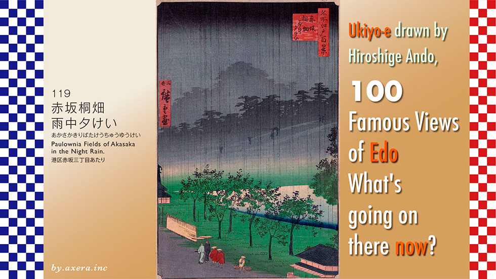
The 119 'Paulownia Fields of Akasaka in the Night Rain' is the last Akasaka painting in the series, issued by Hiroshige II with a firm signature 'Nisei' means second generation.
Please first check the location of the site on a wide-area map. The drawing shows the south-west side of Edo Castle, around the current Akasaka-mitsuke station.
See enlarged map.
This is a view from the west side of Akasaka-mitsuke Subway Station, looking roughly north from Tamachi-dori Street, following the one-way street a little south down the street. The viewpoint is shown with a red gradient.
This is covered by a pictorial map of the time.
The grey coloured areas on this map were town houses where the townspeople lived, red were temples and white were daimyo residences. You can see that the present-day Sotobori Street was almost entirely a large reservoir was named Tameike.
This reservoir was originally a pool of water that flowed from the surrounding plateau. At the beginning of the Edo period, a weir was built at Toranomon and the pond was expanded to secure drinking water and also used as the outer moat of Edo Castle.
In the beginning, the north-western shore of the reservoir was used as a rice field, which was later reclaimed and used to build town houses, so this area was called Akasaka-tamachi.
To the east of Akasaka-tamachi, many paulownia trees were planted to protect the banks of the reservoir Tameike. For this reason, this area was called Paulownia field. Akasaka-tamachi is coloured blue and the paulownia field is coloured green.
In the direction of the viewpoint, two waterways are depicted diagonally, which supply water drawn from the Tamagawa Josui in the direction of Toranomon. At the time of Hiroshige, at the end of the Edo period, the reservoirs were already no longer used for drinking water.
The area around Kajima Corporation's K-Tower, which is now the former Akasaka address, was then Akasaka Uradenmacho. In other words, it was a logistics hub at the time and served as a horse station.
Today's Hitotsugi Dori was actually a town where horses and people were succeeded, hence the name Hitotsugi, which means 'succeeding people'.
On the right side of the viewpoint, across the moat, is the residence of Matsudaira Dewa-no-kami of the Izumo Matsue clan, which is now the official residence of the Speaker of the House of Representatives and the Tokyu Hotel on the moat side below the hill.
Let's take a closer look at Hiroshige II's painting.
In the overall dark colouring, a black gradation is coming down from above, indicating that strong rain is falling from black clouds at dusk.
The figures with umbrellas climbing up the steep hill are drawn here, and this is that steep hill on Aoyama-dori, which has now become a multi-level crossing. Nowadays, there is an entrance to the Nagatacho Subway Station here. The black trapezoidal shape on the far right is the Akasaka Gomon gate. Part of the stone wall still remains at the entrance to Prince Street, opposite Prefectural Hall.
After that, the Benkei moat enters the area, and the black forest beyond is the residence of the three Tokugawa families, the Kii Tokugawa family, where the Tokyo Garden Terrace Kioicho now stands. The forest behind it, slightly smoky from the rain, is the forest around Kojimachi 6-chome, which is now the House of Councillors' residence.
To the left of this hazy forest is the Ii family's residence of the Omi Hikone clan, which is now the Hotel New Otani.
Around the gradient from grey to green are the earthworks and stone walls leading up to the Akasaka Gate, below which was the northern edge of the Tameike pond. Seven paulownia trees are depicted in front of the tame pond, with their pointed fruit ripped open and blackened and withered, giving the scene an early winter appearance.
The jingasa umbrella craftsmen walking along the street and the two samurai with their offerings in red coats also look a little cold, which gives a sense of the sadness of this period.
In April 1856, Hiroshige I also published 52 views of a paulownia field in Akasaka. His viewpoint was from Akasaka 2-chome, a little further from Shimbashi, looking towards today's Tameike-Sanno Station.
In September 1858, Hiroshige I died at the age of 62. About a year later, Shigenobu, a pupil of Hiroshige, became the son-in-law of his adopted daughter Otatsu and took the name Hiroshige II. In June 1859, he published this painting with his signature "Nisei Hiroshige", completing the One Hundred Famous Views of Edo.
It is said that the publisher, Shitaya Uoei, went to the trouble of publishing the work with the inscription 'Nisei Hiroshige' in order to highlight the second generation.
The other three works, which are not clearly inscribed "Nisei" but were published after Hiroshige's death, are said to have also been painted by Hiroshige II: landscape 12 "Ueno Yamashita", landscape 41 "Ichigaya Hachiman shrine" and landscape 114 "Bikunihashi bridge in the snow". Now, what is your judgement?
I actually went to this place where Hiroshige II painted. However, from the viewpoint of Tamachi Street today, all you can see are buildings, so I went to Sotobori Street and looked in the same direction from the edge of the Tameike pond at that time.
The building on the far right is the Sanno Grand Building, which was completed in 1966 at the far end of the former Matsudaira House near Tameike. It is pointed in red on the map.
The large white building beyond is the Excel Tokyu Hotel Akasaka, which opened in September 1969 as the Akasaka Tokyu Hotel, but closed its doors last August and the building is currently being demolished. It was nicknamed the 'Pyjama Hotel' because of its pink and white horizontal striped exterior.
There is a hill going up to Akasaka Gomon gate in the shadow of this building, but you can't see it at all.
The building behind the Tokyu Hotel is the Tokyo Garden Terrace Kioicho. It might be more familiar to you as the former Akasaka Prince Hotel. In the Edo period, this was the location of the Kii Tokugawa family's central residence.
This photo was taken a little further west.
The building at the far end, at the end of the Akasaka-mitsuke level crossing, is the Kojimachi Garden Tower, which was recently built just to the west of the House of Councillors' dormitory. In the painting by Hiroshige II, this is the area where the grove of trees was located at the far end.
To the left is the Garden Court, an annex to the Hotel New Otani. The brown-coloured building is the office building, and to its left, only the white, round roof can be seen, is the hotel building. In the Edo period, this was the location of the central residence of the Ii family of the Hikone domain.
In front of it, the red lettering is the Akasaka-mitsuke station building, Bellevie Akasaka, which currently houses Bic Camera as its main tenant.
This photograph was inserted into a painting by Hiroshige II. As expected of a modern photograph, the large buildings dominate the picture, rather than the people and scenery.
I let the black clouds drift over it and made it rain. It gives the impression of Edo, which has been changing rapidly, and Tokyo, which is in a constant state of flux. Can I express the sadness that Hiroshige II depicted?
Well, this is the last in this series. As we investigated various things, we were able to get a good sense of Edo, its lifestyle and atmosphere at the time, from the paintings left by Hiroshige, and it was a fun time.
Together with the paintings, I could sense the sense of stagnation, anxiety and expectation for the new era of that time. Towards the end of the session, I was finally able to sense that our current lives are connected to those times. Thank you very much.
