

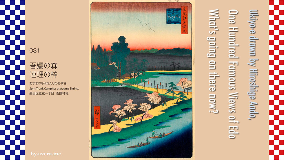
I actually visited one of my favorite places, One Hundred Famous Views of Edo, drawn by Hiroshige Ando, and what the scene is like now.
I actually visited the famous Edo 100 views drawn by Hiroshige Ando, which I love, and what the scene is like now.
030 Sprit-Trunk Camphor at Azuma Shrine, which was located northeast of the Kameido Umeyashiki and north of the Kitajukken River, and its approach. The camphor tree in this company had a bifurcated trunk from about 1.2m above the ground, and was called the Renri camphor tree or Aioi camphor tree, which was the sacred tree of this company.
This time, first, let's unravel the Chronicles of Japan. The 12th Emperor Keiko orders his son Wous to defeat the Kumasotakeru brothers, the western barbarians who rule Kyushu. On the day of the feast, Wous wears his long hair, dresses in the kimono given to him by his aunt, and succeeds in sneaking into the mansion of Kumasotakeru, who is superbly guarded. Wous is praised for his bravery by his brother, Kumaso Takeru, who is on the verge of death, and receives the name of Yamato Takeru. Since then, Wous has come to call himself Yamato Takeru.
Immediately after returning from the barbarian subjugation in the west, his father, Emperor Keiko, repeatedly ordered the barbarian subjugation in the east. Yamato Takeru visits his aunt again and is given the sword, Kusanagi no Tsurugi, and a bag that were in Ise Jingu. In Sagami no Kuni, Yamato Takeru, who was deceived as having a god who is raging in Kuni no miyatsuko, is attacked by fire in the field. When I opened the bag I got from my aunt, there was a flint, so I swept the grass with Kusanagi no Tsurugi, lit a mukaebi, and burned the enemy. Therefore, this area was named Yaizu(burned harborh).
When crossing from Sagami to Kazusa, the god of the sea around the current Uraga Suido causes waves, and the ships of Yamato Takeru are struggling to advance and retreat. His wife's, Ototachibanahime, released the anger of the sea god (Watatsumi), saying, "The wind is coming and the waves are going to sink. This is surely the work of the sea god (Watatsumi). Let me enter the sea in place of the prince. "She said, pulling multiple tatami mats over the waves and entering the sea. Then the waves naturally became quiet. Later people came to call this Hashirimizu(running water).
Seven days later, the kimono of the keepsake that my wife, Ototachibanahime, wore was washed ashore near the forest of Azuma, so I built a platform in the forest and let her go around Mizugaki to make a mausoleum. did.
Yamato Takeru calmed his wife's, Oto Tachibanahime, and then ate, and inserted the camphor tree chopsticks I used at that time into the eastern part of the mausoleum. Later, branches and leaves came out on these chopsticks and stuck to each other, forming a large camphor tree with one root and two trunks. Since the color of the camphor tree leaves does not change, this tree is regarded as a symbol of a strong relationship between men and women, and this is called Renri. Even now, the camphor tree, which is said to be the second generation, is left in the precincts of the Goho Shrine with only the roots dead. In addition, when the disease became epidemic, it is said that the leaves of the sacred tree were used as a talisman to reject the intractable disease. Hiroshige uses the title as Azusa of Renri, but it is said that he may have mistakenly written Azusa for camphor tree, but if you look closely, it does not mean that it does not look like camphor tree.
Currently, there is a place named Sodegaura in Sodegaura City and Narashino City, but it is said that this is a place name named after the legend that the sleeves of the kimono of Oto Tachibanahime have arrived. In addition, the address of this Azuma Shrine, Tachibana, Sumida Ward, comes from Oto Tachibanahime.
It is said that Yamato Takeru, who conquered Emishi, remembered his wife's, Oto Tachibanahime, when he reached the summit of Ashigara on his way home, and lamented "Azuma(my wife) Haya." After that, it seems that the east from Mt. Ashigara came to be called "Azuma".
It's almost a myth, so there are many strange stories, but it's quite interesting.
Let's take a closer look at the picture from above.
Things that look like oystercatchers are flying in the sunrise. It's the Yurikamome now. You can see that the dark green forest continues far away. Isn't the black part a field?
The river that crosses the middle row is Nakagawa, and to the left is Azuma Gongen Shrine, which is now Azuma Shrine. The nobori lined up along the approach to the shrine are the ones that you can thank when your wish is fulfilled. The bifurcated camphor tree is also small, but it is drawn properly.
At the bottom, the contrast between the Edo citizens walking along the causeway and the cherry blossoms, and the green bank and the yellow color of the causeway is vivid. On the Kitajukken River in the foreground, a sightseeing boat operated by the captain and a fishing boat pass each other. The dark blue gradation of the Kitajukken River expresses the depth and flow of the river.
I searched for this place on an old map. In addition, Hiroshige's viewpoint is represented by a red gradation. I'm still quite sick, but I forcibly overlaid the current Apple map. It looks like the view from the sky above Fukujinbashi.
I actually went to this place.
It seems that it is a view seen from the sky around here. The Kitajukken River is well protected by concrete and has a promenade. The causeway and its surroundings are lined with private houses. To the left is Kao's Tokyo office.
I also went to Azuma Shrine, but it's quite small. Compared to the size of the site depicted in the picture, it was much smaller. In addition, private houses are lined up so as to surround the shrine. The shrine is a little higher than the surroundings.
I tried to fit this photo into Hiroshige's painting.
It seems that the viewpoint is higher, so I modified the image of Applemap a little and fitted it. What do you think? Famous places born from the mythical world have been completely driven away by human activities, and have changed completely with convenience and concrete.
 I actually visited one of my favorite places, One Hundred Famous Views of Edo, drawn by Hiroshige Ando, and what the scene is like now.
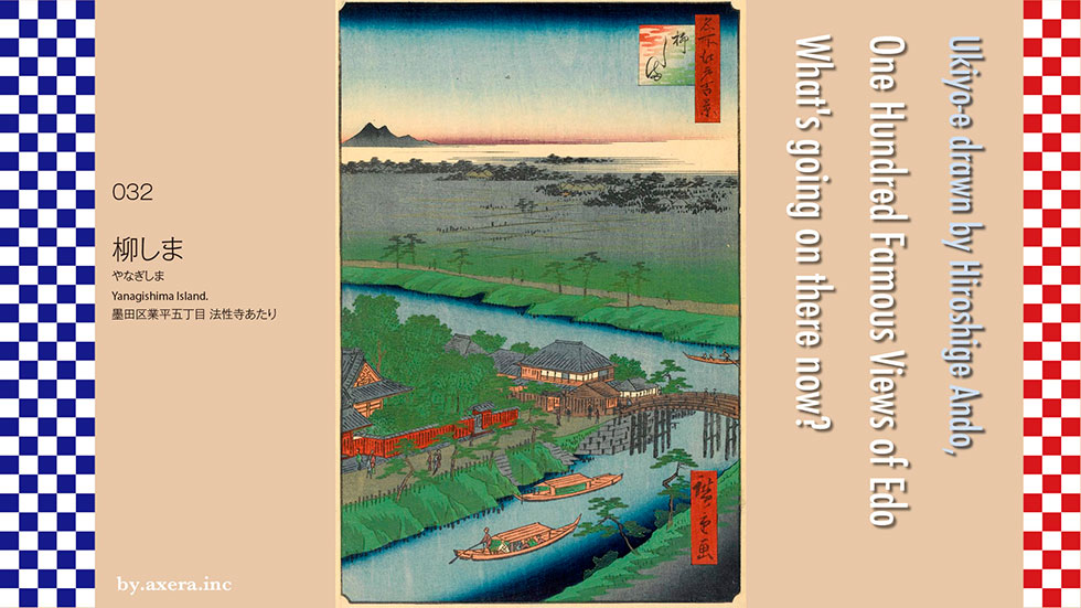
032 Yanagishima depicts the area around Yanagishima Myoken, which was at the intersection of the Yokojukken and Kitajukken rivers.
This Yanagishima Myoken-do is a temple in the precincts of Hosshoji Temple, which was built in the first year of the Meiji era (1492) as a temple of the Nichiren sect by Hosshobou Nissen. Hosshoji Temple was opened. The Myoken Daibodhisattva, which deified the North Star, is enshrined in Myoken-do, and it has become a popular temple for the common people of Edo as a bodhisattva that protects the land, eliminates disasters, and brings longevity.
In addition, there are many restaurants on the north side of Hosshoji Temple, and it is said that this area was very busy. In particular, the kaiseki teahouse "Hashimoto" is known as a high-class restaurant and is described in the book as "Yanagishima has Hashimoto, a delicious wakaayu (small sweetfish) dish that leaves no bones".
In this painting, many people are drawn on the Yanagishima Bridge, and beyond that, the Hosshoji Temple is also drawn. The building on the right is Kyougetsudo in Hashimoto, and when you see the woman on the left in the foreground carrying a flower cake, it looks like the Lunar New Year. The crazy phrase in the fan is "Let's stay at the Crest to Hashimoto and drink seven plums at Hashimoto.". Crest is the Big Dipper of Myoken, and seven plums is Hashimoto's sake served at a restaurant. It depicts the daily lives of Edo citizens who seem to have a lot of fun.
This Hashimoto seems to have been quite famous, and Hiroshige also draws here. In the thirty-six views of the eastern capital, the view from Yanagishima Bridge is that the red wall on the left is Hosshoji and the building with a garden with plum trees on the right is Hashimoto. A man is trying to cross Yanagishima Bridge with a geisha, but it looks like the Lunar New Year when he sees that he is carrying a flower cake on his back. The samurai standing on the bridge with a hood on the crotch is strangely strange.
The Edo scenic spot picture depicts Hosshoji itself, and when you read the commentary, the origin of the principal image is not clear, but there are a lot of people who worship at a very new place. There is a big pine in the precincts, and the main idol Myoken (Big Dipper) descends on the tree for the first time, and it is also called Hoshikudari pine, Millennium pine, or Yogo pine. There is. The big pine tree on the left of the picture is like that. Here too, the person with the samurai has a flower cake. If you look closely, you can see the torii gate, lanterns, guardian dog Chozusha, etc. in detail.
Furthermore, Hiroshige draws from the direction of the Kitajukken River in "Ehon Edo Souvenir". The commentary says, "Located in the northwest of Kameido, the spiritual test of the Hokushin Myoken Daibodhisattva is particularly new, and many people visit on the fairs of the 1st and 15th of every month, and it is a very precious god." Then, this is written. It seems that Kameido Village is visible in the back of the center.
In the Edo Meisho Zue published by Gesshin Saito, Myoken-do is depicted in a fairly wide-angle view. Not only the Two-Jukken River, but also Myoken, Hosshoji, Yogomatsu, and the mountains of Chichibu in the distance are depicted. Well, even if it's half the story, you can see that it was a fairly large site.
Finally, take a look at Hiroshige's family, Yoshikazu Utagawa's famous Tohto famous place, Yanagishima Myokendo. This is a picture drawn from the east side of the Kitajukken River. Many Edo people are drawn on the causeway, Yanagishima Bridge, and on the ship. How is it? Looking at this much, does it make you feel like you went to Yanagibashi at that time?
Hokusai Katsushika, who is now known around the world behind The Kanagawa offing wave back, was a genius painter who changed his name 30 times in his life, moved 93 times, and was an eccentric genius. It is said that the name was changed to "Katsushika Hokusai" because he was born in Katsushika's headquarters because of the influence of Yanagishima Myoken.
According to the temple, Hokusai, who called himself Katsukawa Shunro in 1794, was excommunicated by the Katsukawa school and wished for the poverty of his life and the success of his painting business. He went to Yanagishima Myoken-do, which was famous for "Myoken-sama", for 21 days. On the way back on the day of his wish, he was suddenly struck by lightning and fainted. When he opened his eyes again, he was lucky and became a hot-selling painter. It is said that he visited many times after that and left a lot of pictures of Myoken. According to one theory, the name "Katsushika Hokusai Tokimasa" is said to have been named after the Myoken Bodhisattva, another name for the Hokushin Bodhisattva. Hiroshige Utagawa was born just when Hokusai started to sell.
Also, what made this place famous was Nakamura Nakazo, who has become a classic in rakugo. It is a Kabuki actor's career that has gone up to the highest "Nadia" that you can never become if you start from a position like an apprentice called "Inarimachi".
When the first Nakamura Nakazo received the role of Ono Sadakuro in the fifth stage of the Kanadehon-Chushingura from his benefactor Danjuro, this role was an image of a bit part until then, so I felt lonely. Then, with the advice of his wife, Nakazo visits Myoken of Yanagishima and asks God to give him a new role, but time goes by without doing anything. On the day of my wish, I finally gave up, and on my way home, he encountered a sudden convectional rain and rushed to a soba restaurant to take shelter from the rain. Then a ronin jumps into the store. It is a poor hatamoto with a nice face, and while repelling the rain of Sakayaki (shaven part of the forehead), a kimono with the back of the Kurohabutae skirt stripped off and a tea color obi of Kokura weave. Furthermore, when I saw the Janome umbrella with a sword in a vermilion scabbard, Nakazo fell in love with it. Based on the style of the Ronin Hatamoto that he met as a benefit of Myoken, he started to play a good-looking Ono Sadakuro, who is not just a bandit, and finally received great acclaim from the citizens of Edo.
This story is also a Kodan (storytelling), and the sixth generation Hakuzan Kanda, who is currently on sale, is good at it.
For this reason, many famous actors, storytellers, painters, etc., such as Katsushika Hokusai, Utagawa Hiroshige, Toyokuni, Nakamura Nakazo, Ichikawa Sadanji, 6th Kikugoro, 6th Katsura Bunji, all went here. It has been reported. Many signs and monuments such as the Chikamatsu Monzaemon monument still stand in the precincts.
I searched for an old map to see where this is, and added a red gradation to Hiroshige's point of view. In addition, I tried to overlay a modern map on this, but the position was too misaligned, so I moved the viewpoint. note that. I'm sorry for the playful map.
Let's take a closer look at Hiroshige's paintings from above.
The first thing you can see under the blue sky blur is the Chichibu Mountains. In some manuals, it seems that it is written as Mt. Tsukuba, but since it is in the northwest direction, it is in the direction of Chichibu. What you can see under the haze clouds is the village and fields of Mukoujima or Kanegafuchi.
The Kitajukken River runs beside the middle row, and the lit restaurant Hashimoto is in the foreground. To the right is Yanagishima Bridge, to the left of Hashimoto, and the building surrounded by green trees and a red fence is Hosshoji Temple. A ship is floating on the Kitajukken River, and you can see the traffic of people on the bank.
In the lower row, two ships floating on the Yokojukken River are drawn in large size. There is also a staircase to go up from the river at the pier, which was often used by the common people of Edo. The overall angle is also drawn so that the river draws the shape of Z.
I actually went to this place. This photo was taken at roughly the same angle. Surrounded by groves around the center is Hosshoji Temple. The light blue bridge on the right is the current Yanagishima Bridge, and the light purple and white buildings on the left are the cleaning office and welfare facility for the elderly in Sumida Ward. Beyond that, you can see the Sky Tree for a moment.
According to Wikipedia, from 1965 to 1973, Tokyo began to create evacuation shelters in the event of a large earthquake and fire in the downtown area, and along with this, small wooden houses were crowded around here as well. Evacuation has been lifted. At that time, the chief priest of Hosshoji Temple, who was the chairman of the local neighborhood, demolished the main buildings such as the main hall, guest hall, and kuri, and then built reinforced concrete halls and condominiums, and opened the door widely for the target local residents. The brown building behind is the condominium. I can't confirm it, but the facility in Sumida Ward on the left may have been the site of Hosshoji Temple.
This is a picture of the current Hosshoji Temple seen from the opposite bank. Surrounded by groves, there are no causeways and red fences anymore. The site is also quite small.
This is a front photo of Hosshoji Temple seen from the direction of the Kitajukken River on Asakusa Dori. You can see that it is made of reinforced concrete.
When I went inside, it was reborn as a modern temple.
I actually tried to fit the current photo into Hiroshige's painting. This is interesting, but the angle is a bit low.
So, I combined the slightly hazy photos of the Chichibu Mountains with the street view of Applemap to match only the atmosphere. What do you think?
I don't have it anymore, but Wakaayu was a specialty of the high-class restaurant Hashimoto, which you saw in Hiroshige's paintings. For the time being, it seems that sweetfish were also running up the Jukken River. Now it's three-sided concrete.
I actually visited one of my favorite places, One Hundred Famous Views of Edo, drawn by Hiroshige Ando, and what the scene is like now.
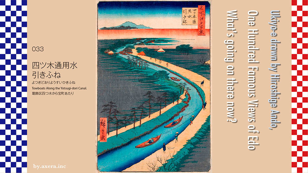
The 033 Towboats Along the Yotsugi-dori Canal is a bird's-eye view of the current Yotsugi to Takaramachi area from the sky above Hikifunegawa-dori. In Hiroshige's painting, the river is winding, but since it was straight from that time, it seems that Hiroshige was adapted from the composition of the painting.
First of all, please see the map of the Geospatial Information Authority of Japan. Actually, the Hikifune River drawn by Hiroshige is represented by a blue line. I also added a red gradation to the points, which is probably Hiroshige's point of view. This should give you an idea of the positional relationship.
I will cover this map with a map from the early Meiji era, around 1867. At this stage, the Arakawa River is the Sumida River, and the current Arakawa River does not yet exist.
I will cover this with a map that shows the current height difference. The Hikifune River is also yellow line for easy understanding. On this map, the areas that are blue are the low areas of the land. Especially dark blue is the so-called zero-meter zone.
The biggest problem since Ieyasu Tokugawa entered Edo was water. Floods often submerged towns and made them unable to be self-sufficient in drinking water.
We have prepared a map that shows the height difference in a wider area. The blue part of this map was originally the sea, but in the dark blue part, even if you dug a well, the water was almost salty. Therefore, it was necessary to draw water from a distance and supply it to the city of Edo, such as Tamagawa Aqueduct. In 1657, after the great fire of the Meireki, a waterway was built from Koshigaya City in Saitama Prefecture to Kameari in Kitakatsushika. From there, the water that was brought to Honjo via Yotsugi and Oshiage was called Kasai Josui or Kameari Josui (aqueduct).
In 1772 (Kyoho 7th year), clean water was a low land, so it was abolished because it was mixed with salt and was unsuitable for drinking, and the river was reborn as an agricultural water and transportation route by ship. Then, from around this time, the water flow was so slow that a towing boat appeared, and the clean water became known as the towing river. Hiroshige is also drawn in seven editions of Edo souvenirs.
The towpath of Yotsugi-dori is about 8km long and meets at the river in Niijuku. Travelers passing through here board a boat. Since it is originally a narrow river, it is called a towing boat because it is pulled from the land by hanging a rope on the boat. The scenery is quite elegant than a boat that goes by paddle.
A modern translation of the commentary looks like this.
After the voyage ends at Kameari, it merges with the main road coming from Senju and crosses Nakagawa river to become Mito Sakura Kaido. It is said that tourists going to Mito and Shibamata Taishakuten used it all together. The rope that connects the boats was pulled a little behind the bow, hanging on the pillar of the thread part of the kite, and it was possible to pull it with a good balance without leaving the shore. At that time, this towing boat was called a Towboats Along the Yotsugi-dori Canal, and it was said that there were about 14 round-trip business from Mukoujima to Kameari.
Let's take a closer look at the picture from above. Beyond the red haze cloud is Mt. Tsukuba. In some commentary, it is said that it is not the Nikko mountain range because of the shape of the mountain, but it is Mt. Tsukuba in the direction. There is a small bridge underneath, but this is the Mito Kaido, and in front of it, there are several boats at the end of the towing boat, and private houses and teahouses are also drawn.
In the middle, the river curves sharply, and three people are drawn, including the traders and travelers of the poles, who are pulling the boat. It didn't take much power to pull the boat, so at that time, an old woman from a nearby farmer was also the puller of this boat.
In the lower row, the passengers on the boat are clearly drawn, and the position of the pillars of the boat on which the rope is hung can be confirmed. On the shore, there are people wearing samurai-style hoods, people who are going to do business somewhere, and people who are wearing Kouri (work bag). Also, if you look at the opposite bank, you can see that the bank is firmly protected by wooden stakes.
Well, I actually went to this place. First, take a tour of Google Earth. The start is from the branch road with Mito Kaido on the south side.
It is an intersection with Heiwa-dori. If you go to the right, you will see the Honden Police Station. You can see the green belt from above.
It is a station of Keisei Electric Railway Ohanajaya.
It is a six-way road in Kameari 1-chome.
This is the end point, and the blue roof on the upper right is JR Kameari Station.
It is the state of the Hikifune River at that time, which appears in the book "Now and the past 100 Views of Edo" published in 1918. Like other urban rivers, the Hikifune River became moribund due to the inflow of domestic wastewater and wastewater from plating factories during the high-growth period. The current Hikifune River, including its tributaries, has been reclaimed and has no waterways. However, the section of Katsushika Ward, which is Hiroshige's point of view, has become a park for citizens to relax under the names of Hikifunegawa Water Park and Yotsugi Medaka no Komichi.
In the same order as the Google Earth tour, you will see the photos of the actual Hikifunegawa street taken in order. First of all, it is just before the first traffic light after parting from Mito Kaido. There is a green pergola, and the road that crosses it is Heiwa-dori.
Is it an image of the waterside? A fine wooden path is also made. And another angle.
There is no water now, but is it made with the image of a murmuring? It seems that children will gather in the summer.
This may have been made with the actual image of the old Hikifune River. Looking from the stream on the left, it looks like this.
The road is narrow, but it looks like a walking path in a park.
There is no water flowing through this dry landscape garden (karesansui), but in the summer there will be a murmuring between the stones.
This is an image of a stream that is completely overgrown with grass.
Was this made with the image of a moat in a castle?
Here you will find roadside trees, walkways, small streams and Azumaya.
This time as well, I combined the photo of Applemap and Mt. Tsukuba actually seen from Sky Tree and fitted it into Hiroshige's picture. In reality, it never looks like this. Think of it as the current image of the Hikifune River, and look at it with a smile.
 I actually visited one of my favorite places, One Hundred Famous Views of Edo, drawn by Hiroshige Ando, and what the scene is like now.
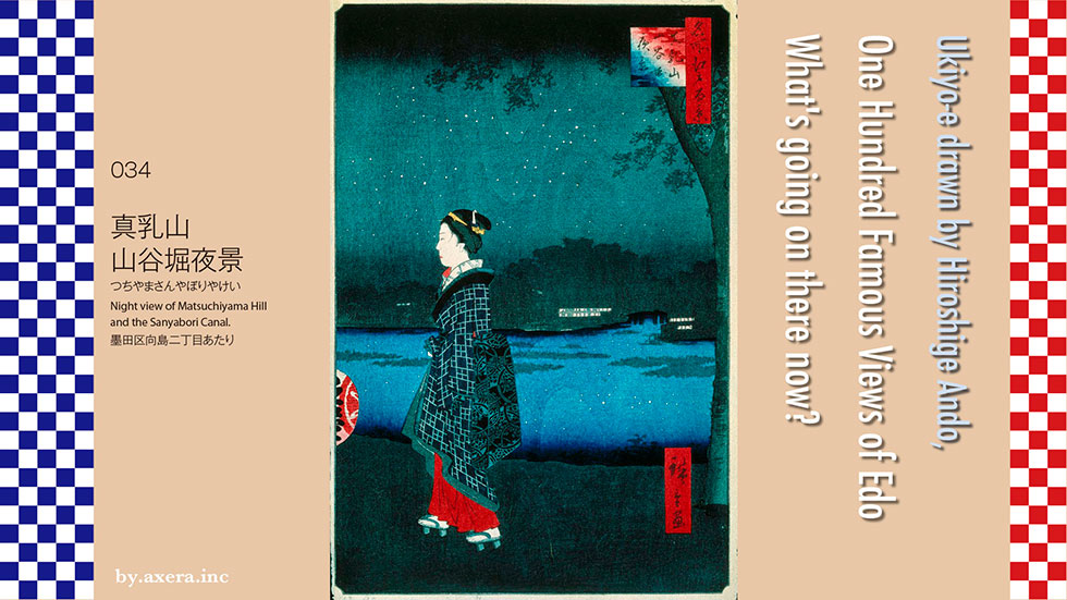
Night view of Matsuchiyama Hill and the Sanyabori Canal at 034 is a night view of the direction of Sanya-bori Imadobashi from the bank of the Sumida River on Mukojima. It is said that the scenery is almost from the front of the torii gate of Mimeguri Shrine.
First of all, please look at the map of Tenpo. It connects two different Tenpo ancient maps, with the north facing up. I put a red gradation in the place that seems to be Hiroshige's point of view.
To the right of this perspective is Mimeguri Shrine. This is a picture of the current Mimeguri Shrine. Due to flood damage, the relocation was repeated and it settled down a little lower, so it became famous for seeing only a part of the upper part of the torii when viewed from the opposite bank of the Sumida River, and it was drawn in many ukiyo-e prints.
When the Mitsui family, a wealthy merchant in Matsusaka, entered Edo as an Echigoya, the characters of Mimeguri decided to protect Mitsui as a guardian shrine, so they still have a strong connection with the Mitsui Group, and Mitsukoshi Department Store other than the main store. It is said that this shrine is enshrined on the roof of each store.
At all the famous restaurants in Edo, Hiroshige draws this Mimeguri Shrine in the view of Mimeguri. The common people of Edo are chatting happily. For this visit to Mimeguri, we used the entrance of Sanyabori, the passing of Takeya, which connects Matsuchiyama Yamashita and Bokutei. This is derived from the teahouse "Takeya" on the Sanyabori side. There is a teahouse called "Miyakodori" on the side of Bokutei, and the beautiful voice of the landlady who calls "Takeya" to get the boat out was popular among the worshipers.
Beyond Hiroshige's point of view was Sanya-bori, where Imado Bridge was located. At that time, in order to go to Shin-Yoshiwara, we took a small boat called Chokibune and went up the digging, but since the river width is only 1 m and the depth is only about 80 cm, it is usually we went up to the land in front of this bridge and walked along the bank toward Yoshiwara Ohomon.
This photo is a remnant of the current Imado Bridge seen from the north side. The bridge itself is gone. There is a large park near the mouth of the river. The white building on the front is the gate where Sanyabori joins the Sumida River. Sanya-bori itself has now been reclaimed and turned into a promenade, which continues to the neighborhood of the Yoshiwara Ohomon entrance.
Hiroshige also draws this place in the picture book Edo souvenir. There is Imado Bridge on the other side of the reeds of the Sumida River, and restaurants are drawn on both sides, and Matsuchiyama Shoden is drawn in the back. Due to the influence of Yoshiwara, the restaurants around here, including the opposite bank, were very prosperous.
There was a restaurant Hiraiwa on the side of Mimeguri Shrine on the viewpoint side, and a restaurant Tamajo on the north side of Imado Bridge. Hiroshige depicts this Tamajo in "Edo's Famous Restaurants Exhausted". However, Tamajo was destroyed by fire during the Great Ansei Earthquake, and then changed to a store called Aritaro, so the store light drawn in One Hundred Famous Views of Edo is Aritaro.
To the southwest of Imado Bridge is Matsuchiyama Shoden. This god was familiarly called Shoden-sama by the common people of Edo, but the god who originally formed the flow of Hindu Ganesha became a joyous heaven when it was incorporated into Buddhism, and business prosperity and marital harmony Was said to be beneficial to. Originally, this small hill was a tourist destination where you can see the sea, mountains, Mt. Tsukuba, and Nikko Mountains in Chiba. However, it seems that the soil was used for the construction of the Nihonzutsumi, which was built to protect the town of Edo from flood damage, and it has become considerably lower.
In the olden days, this area was mostly a sea of mud, and it is said that it was called Matsuchiyama because there was real soil only here. It became a mountain of true milk, and now it is a mountain of waiting milk, and it is now written and called as Mt. Matsuchiyama.
Finally, I will cover this old map of Tenpo with a modern Apple map. Compared to the old map, the position is considerably different, so please refer only to the viewpoint and its site.
Let's take a closer look at Hiroshige's paintings from above.
The first thing that appears is the gradation of the black night sky and the cherry tree that has become a leaf cherry tree. The stars in the night sky are also drawn in white. The geisha depicted isn't the usual beautiful face. The appearance of the woodblock grain in the dark night gives it a taste.
This geisha is Hiroshige's favor and is said to be a woman named "Koman". The dense mountain on the opposite bank is Matsuchiyama, and Imado Bridge is drawn in black above Sanya-bori river, and the lights of the restaurant are shining on both sides. At that time, the only lights were candles or lanterns, so being bright even at night was a symbol of prosperity. At that time, the name "Hori" was known to the common people of Edo as Sanya-bori.
On the surface of the Sumida River, the stars in the night sky are drawn, and on the left side of the picture, the lanterns of the preceding attendant are also drawn, giving the whole picture a spaciousness. This geisha wears clogs with bare feet, so she expresses that she is a stylish and friendly woman like a Tatsumi geisha. The red undershirt that lifts the hem of the kimono and shows it seems to express Hiroshige's feelings.
Well, I actually went to this place.
The Sumida River is in the foreground, and the entrance to Sanya-bori is on the left of the white wall in front, which is slightly black. After that is the park, and beyond that is Matsuchiyama Shoden. If you look at it like this, you can see that it is no longer a very high mountain.
If you take a closer look, you can see Sanya-bori well.
Looking to the left is Azumabashi, and the buildings on the left bank are Sumida Ward Office and Asahi Beer Head Office.
If you look at the direction of Mimeguri Shrine from the opposite bank when you are in the cherry blossoms, you can see that it is still a Sakurazutsumi.
Looking toward Sanyabori at night, it looks like this. It's pitch black, but in modern times there are many lights such as street lights, so it's too bright.
I actually tried to fit this into Hiroshige's painting. It doesn't look like a picture in total darkness, so I made it a little brighter.
At that time, brightness was a symbol of prosperity, but is it still the case? In a society that operates 24 hours a day, do you feel that the brightness is drawing modern people into the darkness? I would like to ask the god of prosperity, Shoden-sama.
 I actually visited one of my favorite places, One Hundred Famous Views of Edo, drawn by Hiroshige Ando, and what the scene is like now.
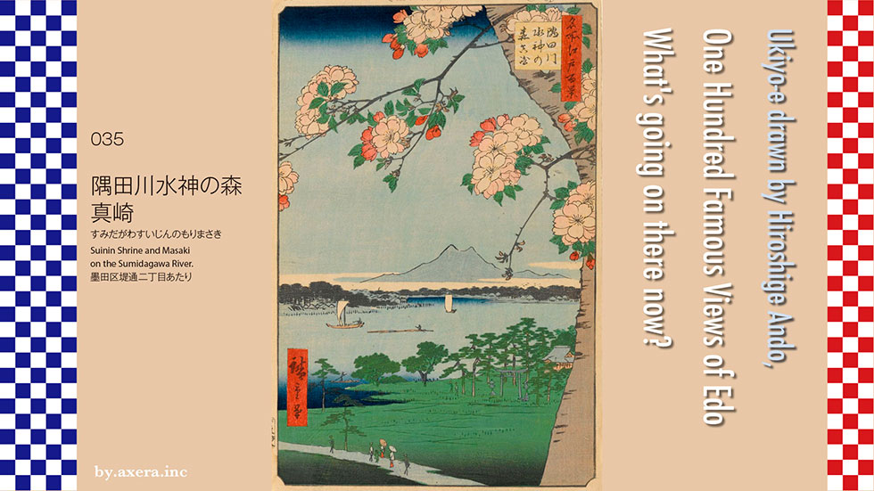
035 Suijin Shrine and Masaki on the Sumidagawa River is a view of the exit of the current Metropolitan Expressway Tsutsumidori from the lower reaches of the Sumida River. Depending on the manual, there is an opinion that the view is from the Tsutsumidori side toward the current Masaki and Ishihama Shrines, but when I look at the site and consider the topography, cherry blossoms, and the location of Sumidagawa Shrine, it is now. I think that it is a picture that looks almost north from around Higashishirahige Park.
First, please check the location from the map of the Geospatial Information Authority of Japan. The blue circle and cross are the Sumidagawa Shrine depicted in the picture. River repairs and road repairs are intense around here, and it has changed significantly from the time when the painting was drawn. In fact, Sumidagawa Shrine itself has moved about 100m.
Next, let's overlay the current aerial photograph on this. You can see the state of the river more clearly. The Sumida River runs aside, and the large and well-protected thick river is the current Arakawa River.
I put a map that shows the height difference on this. The blue part is the low land. The place where this Sumidagawa Shrine is located is a little higher than the surrounding area, and it is called Suijin no Oka or Ukisu. It is a dense forest, and even if the surrounding area is flooded, it will not be submerged. Therefore, it was called the Mizu(water) Shrine, and it became the total guardian of the Sumida River, gaining deep faith as a god of water disasters and fire protection from neighboring villages and boatmen.
Next, I covered it with a detailed map of the early Meiji era, a few years after this painting was drawn. On the right side of the map, the river that winds like a snake is the Old-Nakagawa River. From around Sumida River Shrine to the east, the area around the former Sumida Village is the curved part of the large Sumidagawa River coming from the west, and from the north side, the Ayasegawa River flows in, the flow is disturbed, and you can imagine that water would have overflowed well.
I made this map bigger. Nikko Kaido runs up and down on the left side, and the city area along it is Senju post-town.
During the Keicho period (1596-1615), the Shogunate repaired the Sumidagawa River and built the Sumidagawa River Ohzutsumi (big bank) to protect Mukojima and Honjo from floods. On this map, you can see that Sumida Village has been relocated to the east side, outside the Ohzutsumi, leaving only Sumidagawa River Shrine along the river. The map shows the Ohzutsumi with a pink line.
After this major renovation, 8th Shogun Yoshimune planted a cherry tree on the bank between Sumida Village and Terajima Village downstream to protect the bank. Eventually, it became a famous place for cherry blossoms along with Gotenyama in Shinagawa and Asukayama in Oji. Hiroshige's painting is a view of the Sumida River over the Yae Sakura on this Ohzutsumi.
Please see the old map of the time of Tenpo. On this map, you can see that Ohzutsumi (big bank) has already become a famous place for cherry blossoms, and a row of cherry blossom trees continues from Sumida Village to Terajima Village, around Chomeiji Temple, which is famous for sakura mochi.
By the way, here, I tried to find out the reason why this famous place for cherry blossoms was born. Since Ieyasu Tokugawa entered Edo during the Edo period, the development of this vast wetland has been a problem, for better or for worse. Please see this map first. I tried to show the state of the river at that time with a pink line.
From the west, the Irumagawa, Arakawa, and Tonegawa rivers all flowed into Edo Bay. In other words, as a catchment area, all the rain that fell in the areas from the Chichibu Mountains, Takasaki to Kusatsu, Shirane, Akagi, and Mikuni Pass was poured into Edo Bay. With this, you can see that the flood will occur soon. Therefore, from around 1554, the Shogunate started the Tonegawa eastern transition project.
To briefly explain this, the plan is to gradually transfer the water of the Tonegawa River and let it flow into the Kinugawa River system that comes from the north. As a result, the water of the Tonegawa River was gradually transferred to the Old-Nakagaw River, Nakagawa River, and Edogawa River, and the main flow began to flow into the current Tonegawa River, that is, Choshi. I tried to show the current flow of the river with a red line. This eastern transition project not only controlled floods to protect Edo, but also developed of a new field and established a transportation system by boat.
As a result, the transportation of goods by boat was established from the upstream and downstream of the Tonegawa River to every corner of Edo. The soy sauce culture that came from Kishu on the Kuroshio blossomed in Choshi, climbed the Tonegawa River, headed for Edo in a U-turn, and took root in Noda on the way. The existence of Yamasa soy sauce and Kikkoman soy sauce is none other than the existence of the Tonegawa eastern transition project. The cherry blossoms on Ohzutsumi (big bank), which was the beginning of this, became the theme of Hiroshige's paintings.
Let's take a closer look at Hiroshige's paintings from above.
The first thing that appears is the plumply drawn double cherry blossoms. Young leaves have already appeared, and the buds are drawn in red. This cherry tree symbolically depicts Ohzutsumi (big bank) as a famous place for Yae Sakura (double cherry blossoms).
In the middle, Mt. Tsukuba is drawn at the tip of Kasumi, and the Sumida River, which curves from the direction of Senju on the left, is drawn. It is drawn. The right side is Kanegafuchi, which is the confluence with the Ayasegawa River, and the village beyond that is Yanagihara. You can also see that the inside of the curved Sumidagawa River is reed bed, as shown on the map.
Originally, this area was the end point of the Sumidagawa River, and since the sea started from here, it is said that it became the etymology of "Edo", that is, "The mouth in a sea". Also, for the boatman who goes back by boat, the dense forest and the shrine were also landmarks to let us know that Kanegafuchi, a difficult place in the future, is near.
Sumidagawa Shrine is drawn on the lower right side, and you can also see the torii gate and lanterns. A small boat heading upstream is drawn on the river, but the back side of Sumidagawa Shrine is like a cove, and there was a restaurant there, so it seems that it is heading there. A traveler is drawn on the road in the foreground, but you are heading from the Oshu Kaido to ferry in Hashiba.
Well, I actually went to this place.
This is what it is today. Originally, it is a little further to the east, but in that case you can only see the shadow of the expressway, so this is the point where you can worship to the opposite bank. The bridge you can see is Suijin Bridge, with Shioiri in Minamisenju on the left and the entrance to Tsutsumidori on the Metropolitan Expressway Route 6 on the right.
This is the view of the downstream side. Ishihama Shrine is in front of the gas tank, and this area was called Masaki, and beyond that, the left back is ferry in Hashiba.
This is the current Sumidagawa Shrine. Until about 1946, forests and hills remained, but due to river improvement and road maintenance after that, the location moved about 100 meters and the direction of the torii changed. You can see the Metropolitan Expressway Route 6 behind.
Well, I actually tried to fit the current photo into Hiroshige's picture. What do you think?
Since the angle is low, I combined and fitted Mt. Tsukuba as seen from the Apple map and Sky Tree. Actually, you cannot see Mt. Tsukuba in this direction, but please understand.
Among the famous Edo 100 views, it was quite difficult to identify the viewpoint of this painting. Mt. Tsukuba, which should not be visible along with the Sumidagawa River from any direction, is drawn, the Sumidagawa Shrine is moving, and how to see "Masaki" in the title. Are you looking from Masaki, are you looking at Masaki, or are you roughly saying that it is around Masaki?
In any case, Ohzutsumi (big bank) and Yae Sakura are gone, and now there is no shadow to see.
 I actually visited one of my favorite places, One Hundred Famous Views of Edo, drawn by Hiroshige Ando, and what the scene is like now.
036 View from Massaki of Suijin Shrine, Uchigawa Inlet, and Sekiya is a picture of the current Sujinbashi Bridge eastern end from the window on the second floor of the restaurant in the precincts of Masaki Inari.
First of all, please see the map of the Geographical Survey Institute to see the current positional relationship. Hiroshige's viewpoint is represented by a red gradation.
I put a map of the early Meiji era on this. Did you understand the general positional relationship?
Next, this time, I will start with the explanation of the longest title in this series, "View from Massaki of Suijin Shrine, Uchigawa Inlet, and Sekiya." This is an enlarged version of the map I mentioned earlier.
"Massaki" means the area around Masaki Inari Shrine on the north side of the current Shirahige Bridge west side. The water god of "Suinin no Mori" is the current Sumidagawa Shrine, and at that time the surrounding area was a dense forest. "Uchigawa" has a cove on the north side of the water god forest, and this cove was called Uchigawa. In the back was Mokuboji Temple, which was loved by entertainers, and restaurants were lined up around it. "Sekiya" refers to the area where the Ayasegawa River flows into the area, and in 1189, at the behest of Minamoto no Yoritomo, a barrier was set up to defend the Oshu area. It came to be called "Sekiya".
It is this Ishihama Shrine that is now around what was called Masaki at that time. This shrine, which was called Ishihama Shinmeigu at that time, is an old shrine that is said to have been built in 724. Minamoto no Yoritomo prayed for victory at the time of subduing Oshu. At the time of the Mongol invasion, the imperial court prayed for victory with the 7th Shogun of the Kamakura Shogunate as a messenger. As a result, they won all of these campaigns, and since the Middle Ages, this shrine has been revered by many people, including samurai.
Masaki Inari Shrine is on the Sumida River side of the precincts. It was annexed to Ishihama Shrine in 1926 and became a small one, and now it is with Fujizuka. In terms of location, Ishihama Shrine has moved to the location of the former Masaki Inari Shrine. It is said that this Masaki Inari was enshrined by Moritane Chiba, the lord of Ishihama Castle, who was in this place around 1532 to 1554. It is said that the fox that emerged from the fox hole in Okunomiya was very famous along with the fox at Mimeguri Shrine on the opposite bank. After that, many people visited from the middle of the Edo period, and around 1757, there were many restaurants selling tofu Dengaku made from Yoshiwara tofu. It is said that this Hiroshige painting is a view seen from the second floor of the window of Kinoeneya in it.
At that time, Hiroshige and Toyokuni drew All Toto high-class kaiseki meals “Soroku”, which depicts the restaurant Kinoeneya in the precincts of Masaki Inari. I enlarged that part on the right side and put it in.
This is Hiroshige's "Tohto Meisho-zue, a picture of passing the Sumida River", which depicts a boat passing through Hashiba, slightly downstream of the viewpoint, from the downstream. I tried to connect three vertical images. "I don't know the name in front of this shrine, but this flow of the Sumida River," quoting a famous song written by Lieutenant General Aiwara, drawing a city bird in the picture, in a scenic place throughout the four seasons Explains that there is. In addition, many women are playing in the picture, and in the scenery, Suinin, Uchigawa, and Ayasegawa River are also named, and on the left side are Masaki Inari and Ishihama Shinmeigu.
Actually, at that time, the place name "Masaki" was also written as "Masaki" and pronounced "Massaki", and it became very popular because it was the first to benefit from visiting. Therefore, during the Hiroshige era, the Dengaku teahouse in the precincts was very prosperous with the promotion of "If you visit Masaki Inari and then go to Yoshiwara, things will be successful" in order to attract customers with the Shin-Yoshiwara store. ..
According to a book around 1757, there are several Dengaku teahouses such as Kinoeneya, Kawaguchiya, Tamaya, Ineya, Kiriya, and there is a description that Kinoeneya was the most delicious.
Also, in front of the stone monument that depicts the history of Masaki Inari, a large number of votive tablets are written with the words "Kanau" and the wishes of many people.
Nowadays, Ishihama Shrine is also a beautiful cobblestone shrine with a parking lot, part of which is Ishihama Castle Ruins Park, and on the west side there is a slightly stylish cafe called Ishihama Saryo "Raku". Was there. At that cafe, Dengaku was revived as a menu as a specialty at that time.
Dengaku is an abbreviation for Dengaku-yaki, and it starts with tofu that is skewered and grilled with miso. The name comes from the fact that the skewered shape of tofu resembles the appearance of Dengaku Hoshi, who worships the god of rice fields at the time of rice planting, dancing on one leg. However, the Dengaku at this cafe was a fashionable Miso Dengaku with a modern photo of matcha.
Let's take a closer look at Hiroshige's paintings from above.
The first thing that appears is the pillars, walls, and shoji doors, and birds are flying in groups outside the round windows. It seems that this is not a geese but a common oyster catcher. On the left pillar, camellia flowers are peeked out to represent the seasons.
In the middle row, Mt. Tsukuba is drawn in the middle outside the window, a slightly larger boat with plum branches and white sails piercing it, and the dense water god forest and the torii gate of the Mizu shrine are hidden on the right side. The Black Forest in the distant view is Sekiya, and below that, the Sumidagawa River meanders from the left, and the right side is not visible, but it continues to Uchigawa. On the surface of the river, a boat carrying a person who seems the Suijin ferry and a boat carrying supplies covered with a cover are drawn.
In the lower row, there is a boat surrounded by plums that is about to head for Masaki Inari, and on top of that is a raft that may have come from the Chichibu area via Arakawa. The pink of the plum blossoms in the blue gradation under the window shines.
By putting the whole scenery in the window instead of writing it all over, it gives a sense of perspective and makes you feel like you are in a tourist spot.
Well, I went to the place where Kinoeneya seems to have been, which was actually this point of view. This is the view from the end of the current Ishihama Shrine from the Sumida River. The bank is too high and I can't see the scenery.
So I went to the top of this bank. The width of the river has widened since that time, and the Metropolitan Expressway runs on the opposite bank, but the left side of this screen is just the view outside the window. The blue bridge is Suinin Bridge, which is hidden to the right and cannot be seen, but there is now Sumidagawa Shrine, where the water god forest at that time was. Of course, I can't see Mt. Tsukuba.
I fitted the left part of this photo into Hiroshige's painting, and fitted the white plum blossoms of Yushima Tenjin. Doesn't it make you feel like traveling when you see this picture with the image of Miso Dengaku? Also, by the time of this painting, Kinoeneya was a little lonely, and I think Hiroshige painted this painting as a promotion for the store.
 I actually visited one of my favorite places, One Hundred Famous Views of Edo, drawn by Hiroshige Ando, and what the scene is like now.
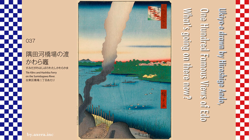
The 037 Tile Kilns and Hashiba Ferry on the Sumidagawa River is a picture of the Sumidagawa River bank around Hashiba 2-chome, over the smoke of the Imado ware porcelain, the Hashiba ferry, and the direction of the Sumidagawa Shrine.
First of all, I tried to put a red gradation on the current Apple map from the viewpoint of this Hiroshige picture, so please check the location.
The road that passes through this "Hashiba ferry" has long been a road heading north. In the early Edo period, the former Oshu Kaido departed from Nihonbashi, turned right at the end of Mitsukoshi, headed toward Sumida River, and when it reached Asakusabashi, it went through Edo-dori to Kuramae.
After passing the famous loach "Komagata Dozeu", join hands with Kannon at Kaminarimon, turn right, turn left at the current Tobu Asakusa station, and go to the intersection of Kotoibashi West.
Continue straight ahead and you will see Matsuchiyama Shoden on your left. After passing Imado and Hashiba, you will reach the current Shirahigebashi Nishizume. This is the place where it is said that there were about 50 Imado ware kamado at that time.
At that time, in front of Shirahige Bridge, we crossed the opposite bank by boat from the bridge, and then headed north on the Ohzutsumi.
After the Senju Ohashi Bridge is built, the main street heading north will change to the current course that passes through Minami-Senju Station, and will become the former Nikko Kaido. Even so, Hashiba ferry will continue to be used as it is, and this area will be regarded as a fashionable place, and villas of daimyo and wealthy merchants will line up along the banks of the Sumida River, and famous restaurants will be built.
Hiroshige has drawn pictures on this theme many times, perhaps because he liked this scenery very much. This time, I collected related ukiyo-e prints. Please take a closer look. First of all, please take a look at the panorama of "Tohto Meisho-zue, a picture of passing the Sumida River" which was introduced last time. The passing of Hashiba ferry is the oldest passing in the Sumidagawa River, and it is said that Ariwara no Narihira of Ise Monogatari also crossed here. The city bird depicted here, that is, the black-headed gull, is clearly drawn with the song that thinks of Ariwara no Narihira's wife in the Ise story in mind.
Hiroshige II is a famous place in the Tohto famous place and depicts Imado from a different angle. In the evening when plum blossoms bloom, a craftsman who is baking tiles is depicted with the Sumida River in the background. Along with the raft floating on the surface of the river, you can feel the time flowing very slowly at that time.
This area is also depicted in Edo's proud 36 Ko, a collaboration between Toyokuni III and Hiroshige II. The picture on the left is almost the same as the composition of the first Hiroshige of 036, and the smoke of the Kamado is drawn outside the window where the woman turns around. The picture on the right is a view of the snowy landscape of Hashiba from the upstream, and Azumabashi is drawn small in the distant view.
It is a picture of Hashiba with the same snow scene drawn by the first and second generations. Hiroshige II, on the right, is the Sumidagawa eight beauty spots, and depicts the snowy landscape that is steadily falling as a passage of Hashiba as seen from the Imado side. Sumidagawa Shrine is drawn on the left side of the distant view.
On the left side, the first Hiroshige draws the snow scene of the same Hashiba over Imado Bridge and Mt. Sumidagawa Shrine is hidden by the red haze clouds at the top, but it is a quiet and beautiful snow scene.
The first Hiroshige also depicts a cooking teahouse called Yanagiya, which was on the way to Hashiba, even at the Famous Restaurant in Edo. Did you come here for sightseeing because it is a scenic place? You can hear the interaction between a parent and child playing with butterflies and two women. I feel that this picture, which is a photograph of the time, will take us to Hashiba at that time in an instant.
Now, let's take a closer look at the actual Hiroshige picture from above.
First of all, the smoke of the Kamado is rising in the sky at the top. There is a blue blur line at the bottom of the sky, which is a printing technique called "shading blur" that can only be seen in the first printing.
Mt. Tsukuba flows to the left of the middle row, and the Ayasegawa River flows from the right of the Sumidagawa River below it. On the right are the water god forest of Sumidagawa Shrine, the double cherry blossoms that decorate the Ohzutsumi, and several private houses in Suda, Sumida Village. Two boats cross the historic ferry on the surface of the river.
A swimming city bird is drawn on the lower river surface, and "shading blur" is also used for that part. In the lower left, two large Imado ware kamado, which are the sources of smoke, are drawn. The blue gradation of the Sumida River is used very effectively.
This is what Imado Shrine looks like now. Today, it is famous as the place of the end of Soji Okita, a priest at the end of the Edo period, but along with it, a monument and commentary version of the birthplace of Imado ware stand.
The guardian dog pedestal beside this Imado ware monument is engraved with the names of 42 Imado ware potters when it was dedicated in 1752. At that time, we can see that there were so many kamado around here.
Imado ware mainly produced daily necessities, clay dolls, and roof tiles, and was a representative pottery of Edo. According to folklore, it was already burned around 1573. Since it was originally a town in Edo where there are many fires, it seems that the pottery pots that use fire were concentrated on the side of the Sumidagawa River. After that, due to the Great Kanto Earthquake and the Great Tokyo Air Raid, the appearance of the town changed completely and moved to Sumida Ward and Katsushika Ward, but it seems that only one Kamado remains in Imado.
I actually went to a place that became Hiroshige's point of view. However, I can only see Shirahige Bridge to make me laugh. The transfer of Hashiba ferry was a little before this, but with the completion of Shirahige Bridge in 1915, the curtain was closed on its long history of more than 1000 years.
I tried to fit this picture into Hiroshige's picture. What do you think?
There were about 28 representative crossings of the Sumidagawa River. Among them, this Hashiba ferry was the oldest recorded ferry. In the book of Dajokan in 835 during the Ritsuryo era, there is a book that says "Sumita no Watashi". Hashiba ferry has been loved for many years with many other names such as Shirahige ferry and Sumida ferry, but now it has given its role to the iron bridge. I don't know if the reason is convenience or speed, which is now too obvious.
The last Ferry of the Sumidagawa River was Tsukuda, which was abolished in 1964, the year of the Tokyo Olympics, with the completion of Tsukuda Ohashi.
The disappearance of this emotional means of transportation, which is called passing, seems to be symbolized by this rising smoke.
 I actually visited one of my favorite places, One Hundred Famous Views of Edo, drawn by Hiroshige Ando, and what the scene is like now.
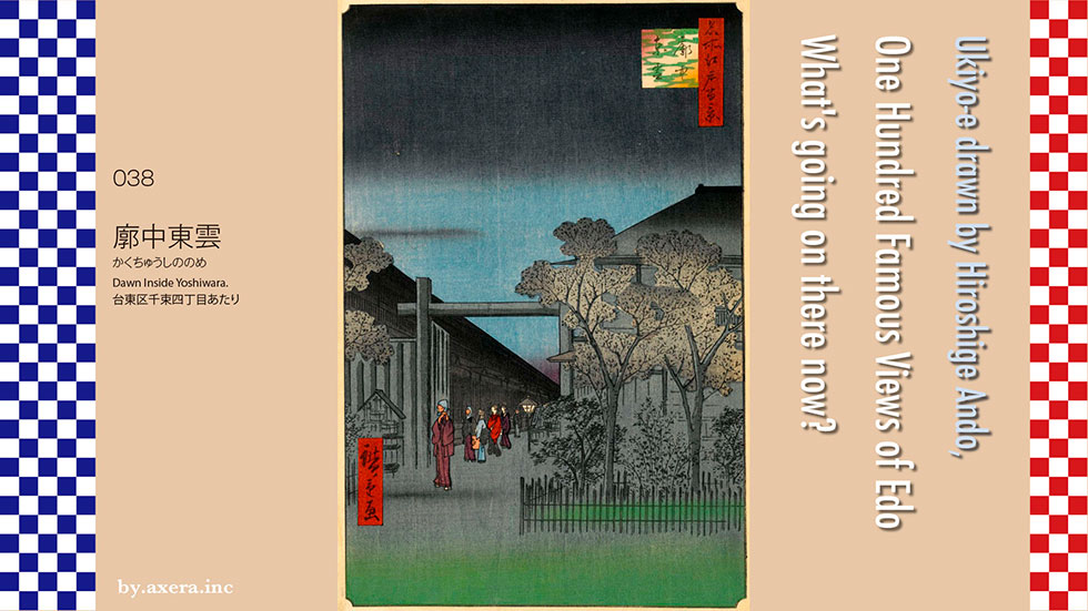
38 Dawn Inside Yoshiwara is dawn of Shin-Yoshiwara, looking southeast from around Senzoku 2-chome, Taito-ku.
First of all, please see the map of the current Geographical Survey Institute to identify the location. I put a red gradation, which is the viewpoint of Hiroshige's painting, there.
I also covered it with a map from the beginning of the Meiji era. The roads in Shin-Yoshiwara are almost the same as they are today, except for the surrounding moat.
There is a detailed view of Shin-Yoshiwara published in 1846. It was about 10 years ago when Hiroshige drew this picture. At that time, nearly 20,000 people were working in this place.
The winding road on the right is "Emonzaka", which descends from the Nihonzutsumi, and is the only official passage to the Yoshiwara. After passing through "Ohmon (gate)" to the left, Yoshiwara Yukaku was an isolated paradise surrounded by a high wall and a moat called "Ohaguro-dobu (ditch)".
From small stores to large stores, you can see that they existed in a crowded manner.
Hiroshige draws this Shin-Yoshiwara from various angles. First of all, please take a look at the image that gives a bird's-eye view of the entire Shin-Yoshiwara from the north in a vertical triple series. On the map, it is a picture seen from this angle. The main street is called Nakanocho, and mainly guide teahouses are lined up, and in the spring, sakura were planted inside the fence of the street. The lower left is the main gate at the entrance, and the closer to this gate, the more luxurious it was.
This picture is a view of the direction of Nihonzutsumi from the sky above the city of Shin-Yoshiwara. On the map, it is a picture seen from this angle. You can see a lot of people coming here by walking along the bank. At that time, it was common to go up the Sumidagawa River by boat, land at Imado, and walk or go to the embankment. The black tree on the left is the "return willow". What is on the roof is a tub filled with fire protection water.
This picture depicts a Japanese restaurant Harimaya, which was just before going out from Shin-Yoshihara to Nihonzutsumi. On the map, it is a picture seen from this angle. A teahouse with bamboo blinds on the bank is also drawn as "return willow", and a lot of customers come from the bank and feel that it is crowded. When going in and out of Yoshiwara, the man usually wore a headgear.
This picture depicts the scenery of cherry blossoms at night planted in Nakanocho in spring. On the map, it is a picture seen from this angle. In general, playing in Yoshiwara was a system in which you first went to a teahouse in Nakanocho, invited a prostitute to set up a banquet, and then entered the teahouse with the guidance of a teahouse man. In this picture, two Tayu are drawn together with various people. It seems that he is in the process of entering the store with Kamuro and Shinzo. However, it seems that he never entered the store with the highest-ranking tayu unless he was a very high-class customer.
This picture is a snow scene in the morning when I saw the "return willow" through the main gate. On the map, it is a picture seen from this angle. As a business rule of Shin-Yoshiwara, customers should not stay for more than a day and night, so they had to go home in the morning. After 4:30 in the morning, the time when the guest and the prostitute broke up was called Kinuginu. This is a very tasteful picture that depicts the lonely time zone of such a guest and a prostitute with the scenery of such a snowy day.
This picture is from Nakanocho on the main street, looking in the direction of 1-chome, Edocho. On the map, it is a picture seen from this angle. In this painting, Tayu was responsible for all the expenses that Tayu was carrying, such as her younger sister called Shinzo and Kamuro, and having a lantern. In addition to the practice of performing arts, you have to buy new kimonos and decorations every season, and even the highest-ranking prostitute called Tayu, who looks gorgeous, seems to have had a hard time living.
This picture depicts the Oiran parade, which parades around Nakanocho on the main street immediately after entering Ohmon. On the map, it is a picture seen from this angle. It is said that Yoshiwara became a big crowd at the Oiran parade when the cherry blossoms were the most picturesque, as it was a chance for ordinary people to meet Oiran. It's not an ordinary thing to meet this Oiran, who has been honed since childhood, is excellent in all the arts, has good looks, and does not talk to people he does not like. It is said that it cost about 500,000 yen just to enter the store once by an individual. However, I couldn't realize that I had to go at least three times. It seems that there was no one-off story like "Kohya Takao", which is famous for Rakugo.
The prostitute depicted in the picture on the right is Miuraya's Takaodayu, a rakugo storyteller, who appears in the Kabuki performance "Sukeroku Yukari no Edo Sakura" from the kimono pattern of the dragon. It seems that it is drawn with Takao Tayu of "Konya Takao" as a model. Whereas the new clogs in front have two teeth, the Tayu has larger and taller three teeth. You can't see the obi, but when you look at it from the front, it looks like the word "heart". According to one theory, it means that you sell yourself but not your heart.
The prostitute depicted in the picture on the right is Agemaki-tayu Miuraya, who appears in the Kabuki performance "Sukeroku Yukari no Edo Sakura" from the kimono pattern of the dragon. It seems that it is drawn with the model of Takao-tayu or Rakugo," Kohya Takao ".
Whereas the Shinzo clogs that go ahead have two teeth, the Tayu has larger and taller three teeth. You can't see the obi, but when you look at it from the front, it looks like the word "heart". According to one theory, it means that I sell myself but not my heart.
The picture on the left is a picture of "Kinuginu", where Tayu is coming to the front of Ohmon to send customers returning in Kago. You can see the "return willow" in the back left. Tayu layered many kimonos with cotton called "Awase" with a flashy pattern, and stabbed many hairpins and kōgai on Shimada's style tall hair. Tayu Yoshiwara's behavior was like a female fashion leader at the time, and these paintings also played an advertising role for Yoshiwara. However, in reality, Yoshiwara in the late Edo period has declined, and it seems that high-class prostitutes no longer exist.
Then I tried to find out why Yoshiwara was created.
First, I tried to show the old and new Yoshiwara on the Apple map. It is said that when Ieyasu Tokugawa opened the Edo Shogunate in 1603, a part of it was moved from the Nichōmachi Yukaku, which was under the castle of Sunpu (now Aoi-ku, Shizuoka City). After that, two-thirds of the Edo population was male, so prostitutes were scattered throughout Edo City and started operations. In 1617, Shogunate tried to open a shogunate-approved Yukaku called Yoshiwara on the north side of the present Ningyocho, but the illegal prostitutes did not disappear at all. The blue circle on the map.
In October 1656, the Shogunate ordered the relocation of Yoshiwara, and in the New Year of 1657, a great fire of the Mereki broke out, and it was finally decided to move to Senzoku Village as a new Yoshiwara. In 1668, Shin-Yoshiwara began operations with a large-scale crackdown on private slaughter. It is an orange square on the map.
This is a list of Shin-Yoshiwara drawn by Hiroshige in the latter half of the Edo period. At first, about 20,000 people lived in it, and after that, along with Kabuki, it became the center of Edo culture. To go. However, there were many fires in Yoshiwara, and from the relocation of Shin-Yoshiwara to the end of the Tokugawa shogunate, there were 22 fires in about 191 years. However, the temporary business after burning down was more profitable than usual. Therefore, when the fire broke out, the fire extinguisher rushed to the outside of the gate and waited for the fire to be extinguished, and the owner and the people concerned seemed to be waiting for it to burn out secretly.
However, the big earthquake in Ansei the year before Hiroshige drew this picture was different. There are records that more than 600 prostitutes have died, but in reality, more than 1,500 to 2,000 people have died in fires and collapses. This picture is a popular theme at that time called "namazu-e", and it is a figure in which a prostitute disciplines the big catfish that caused the earthquake.
At the end of the Edo period, the number of privately-owned prostitutes increased in Shin-Yoshiwara, and the number of prostitutes who could perform arts such as songs, shamisen, and dance decreased. Therefore, a business called geisha will be born that supports only the artistic aspects of such prostitutes.
This photo captures Shin-Yoshiwara in the early Meiji era.
After the Meiji era, the social gathering places of the political and business worlds moved to Hanamachi, where geisha are located near the center of Tokyo, and Yoshiwara Yukaku was gradually forced to shrink. According to 1902 records, no more than 2000 people lived in Yoshiwara. Eventually, when the Prostitution Prevention Law came into force in 1957, Yoshiwara Yukaku quietly ended its history, and some turned into "Soapland".
Let's take a closer look at Hiroshige's paintings from above.
The darkness that has not yet dawned is drawn above.
In the middle row, the blue sky and the slightly red sky are drawn in gradation. At the center, you can see that there are several customers who are about to pass under a gate and some prostitutes who see them off, the so-called late morning (Kinuginu) time zone. On the right is a colorless night cherry blossom, and on the left is a large water tank unique to Yoshiwara, which has many fires. The cherry blossoms were planted on March 1st of the lunar calendar and were removed as soon as the flowers were scattered, and then replaced with irises.
The lanterns lined up in the center of the street are called "Tazoya lanterns", and they have pillars in the town as a precaution because a famous prostitute named "Tazoya" was killed around 1714. It is said that the lanterns have come to light.
Well, I actually went around here.
These are Sanyabori and Nihonzutsumi, where people were coming one after another at that time. This is a photo of the direction of Imado, but now it is a promenade.
This is a photo of the direction of Imado from the corner of the road that turns from the bank to Ohmon. It is a monument "return willow" with a small tree in the middle replanted.
There was a Sakuranabe (horse meat hotpot) shop on the other side of the bank, opposite the "return willow", because it is said that you will use horsepower to kick Yoshiwara away, but there are still two shops open.
This is the current Nakanocho, which was the main street of Shin-Yoshiwara, ahead of the Ohmon at that time.
This is the current google street view of Shin-Yoshiwara from Hiroshige's point of view.
I processed this photo like dawn and fitted it into Hiroshige's painting. How about.
As a material to identify Hiroshige's point of view, the crown tree gate depicted in the painting was only in Kadocho. The situation of the cherry blossoms in front of the gate is like the entrance to Edo Town. There is no signboard for the town name that was originally displayed next to the gate, and the town name characters in the rainwater tank are intentionally made unreadable.
Hiroshige also announced this painting the year after the earthquake, when the reconstruction of Shin-Yoshiwara was about to reopen. Given this, I think Hiroshige was drawn to send ale to the new Shin-Yoshiwara. Congratulations to Shin-Yoshiwara for the new dawn.
 I actually visited one of my favorite places, One Hundred Famous Views of Edo, drawn by Hiroshige Ando, and what the scene is like now.
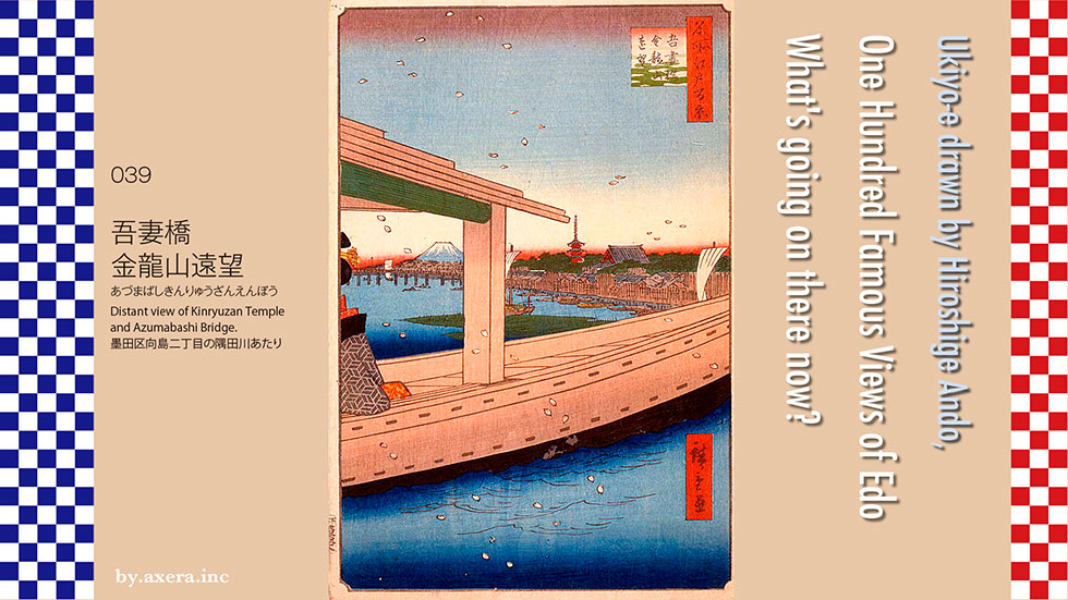
039 "Distant view of Kinryuzan Temple and Azumabashi Bridge" depicts the view of Sensoji Temple and Azumabashi bridge over the boat floating on the Sumida River near Mukojima 2-chome, Sumida-ku.
First of all, take a look at the current Apple map. I put a red gradation in the place that seems to be Hiroshige's point of view. Today, the Tobu Line railway bridge, Kotoibashi bridge, and the glasses-shaped Sakurabashi bridge are built upstream of Azumabashi bridge. It seems that the scenery was just seen over the boat floating around the lower reaches of Sakurabashi bridge.
I put a map of that time on this. You can see that Sensoji Temple occupies a fairly large area.
Next, let's take a closer look at Hiroshige's paintings. The place depicted in the picture was the passing of Takeya from Sanyabori to Mukojima, but this boat is a boat for playing in the river of Edo citizens called a roof boat, and it is surrounded on all sides by bamboo blinds. Today, the boats that surround the Sumida River and Tokyo Bay with shoji screens are called houseboats, and at that time they were mainly used by samurai. On this left bank, Mukojima, there is Mimeguri Shrine, and many restaurants, including Hiraiwa, were lined up around it. The rich man, who is enjoying cherry blossom viewing from the surface of the river leisurely with a geisha, can imagine whether he will go there or return to the wind in the cherry blossoms storm. What's more, it looks like a pretty fashionable woman, as you can imagine from the tortoiseshell hairpin of this geisha, who can only see half of her body, and the pattern of the kimono she wears.
Due to the resolution, I enlarged the main part of the post-print, which is not the first print, but has a slightly different color, and placed it on the right side. From the right, you can see the temple and five-storied pagoda of the main hall of Sensoji Temple on the other side of Kinryuzanshita-Kawaramachi, Yamanoshuku Rokukencho, Yamanoshukucho, and Hanakawadocho.
From under the roof of the boat, Mt. Fuji, which still has snow on its peak, and Azumabashi bridge are drawn on the other side of the cherry blossoms storm.
I actually went here. That is this photo. The bridge in front is Kotoibashi bridge, and you can see the Tobu railway bridge on the other side. I can't see Azumabashi bridge at all. Sensoji Temple is also behind the building and cannot be seen at all. On the far left are the Sumida Ward Office and Asahi Breweries Headquarters.
This is a picture of the same place published in the book "One Hundred Famous Views of Edo" published in 1919. The five-storied pagoda of Sensoji Temple is barely visible here.
This is a photograph of Hiroshige's viewpoint from the left bank of Kotoibashi bridge during the cherry blossom season. The area around the white boat on the left seems to be the viewpoint.
This is a photo that is a little closer with the angle raised. In the foreground is the Sumidagawa Terrace on the right bank of the Sumida River.
It is Mimeguri Shrine on the left bank side of the viewpoint. At that time, many restaurants were lined up around this area.
This is a photo of the current Azumabashi Bridge from the right bank, looking toward the ward office. The current Azuma Bridge is a red steel-framed four-lane sidewalk with two sidewalks.
It was first built in October 1774 at the request of the citizens at the place where Takecho ferry had been handed over as the last bridge in the Edo period. Therefore, tolls were collected for each two sentences from passers-by other than samurai, and at that time it was called "Okawa-bashi Bridge" from another name of Sumida River.
From the time it was replaced in 1876, it became known as Azumabashi, and in 1887 it was reborn as the first iron bridge on the Sumida River. This is the postcard issued at that time. It was a very fashionable bridge, wasn't it?
This is a photograph of the viewpoint from the right bank of Azumabashi Bridge. You can see the Tobu Railway's iron bridge, and beyond that is Kotoibashi Bridge.
This is the current Sensoji Temple Hozomon gate and Five-storied Pagoda. The current five-storied pagoda is on the left side of the Hozomon gate when facing the main hall, but it was on the right side when the painting was drawn.
This is a series of three works of the panoramic view of Sensoji Temple drawn by Hiroshige. The lower side is the Dempouin side, and the upper side is the Nitenmon side. You can see that the five-storied pagoda is on the right side of the Hozomon gate, which was called the Niomon gate at that time.
At Sensoji Temple, the Buddhist statue on the net of the brothers who were fishing in the Sumida River in 628 was renovated into a temple by the brother's boss, Nakatomo Haji. It is said to be the beginning. The picture on the left is Hiroshige's origin.
One theory is that the Kannon statue, which was enshrined at Iwaidokannon in Iwabuchi, Hanno City, was washed away by heavy rain about 100 years before the founding of Sensoji Temple.
After that, Sensoji Temple developed greatly, and in the Edo period, it was regarded as the Kannon sacred place of the Tokugawa Shogunate and attracted many worshipers. Hiroshige's drawing of the bustle of Lunar New Year Fair at that time is the picture on the right.
The five-storied pagoda was destroyed by the bombing of Tokyo by the US military in 1945, but was rebuilt in 1973 with reinforced concrete and aluminum alloy tiled roofs.
This is the main hall of Sensoji Temple, which disappeared in the 1945 bombing of Tokyo, was rebuilt in 1958, and was dubbed into titanium roof tiles in 2009, which became a hot topic.
This is Nakamise Street, which continues from the busy Kaminarimon Gate, but thanks to Corona, tourists are completely hidden.
Then, I modified the photo from the current Hiroshige's point of view and fitted it into the picture. What looks big is not Azumabashi bridge, but Kotoibashi bridge. What do you think.
It's a luxurious and rich river play where you can see the crowded Sensoji Temple from a distance by letting a geisha sacrifice on a roof boat in the cherry blossoms storm, but strangely, it doesn't look stylish.
 I actually visited one of my favorite places, One Hundred Famous Views of Edo, drawn by Hiroshige Ando, and what the scene is like now.
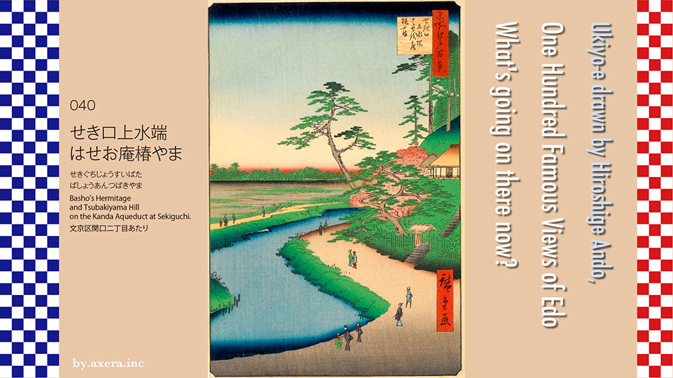
040 Basho's Hermitage and Tsubakiyama Hill on the Kanda Aqueduct at Sekiguchi depicts Bashoan and its surroundings on the side of the Kanda River under Chinzan-so, Sekiguchi 2-chome, Bunkyo-ku.
First of all, check the location on Applemap. I added a red gradation to Hiroshige's point of view. Hiroshitge were looking almost west along the Kanda River.
I overlaid an old map from the time of Tenpo on this. I distort it a little forcibly and focus on the viewpoint. Basho lived beside the Hachimansui Shrine, the guardian deity of Kanda Aqueduct next to Komatsukabashi.
You can see a weir beside Renge-ji Temple, but this is a facility called Oarai Weir that stops water, and because of this weir, this area was called Sekiguchi. In addition, Kanda Aqueduct drawn from Inokashira Pond in Kichijoji is divided from here by adding water from the Zenpukuji River, Myoshoji River, and Hanazono River on the way. Kanda Josui is used to water the pond of Koishikawa Korakuen in the Mito family's residence through the current Kohinata and Makiishi-dori, and from there, it crosses the Kanda River along the hangout downstream of the current JR Suidobashi station. Water was supplied to Nihonbashi and Kanda.
The surplus water was poured from Omagari to Iidabashi as the Edo River, through a deep cut made by the Date feudal clan in Sendai with Ochanomizu, and then into the Sumida River as the current Kanda River.
Today, this Komatsukabashi also moves a little upstream and moves under the hill. The area around the water shrine where Basho lived was almost the residence of Hosokawa Etchu no Kami.
If you look closely, you can see that there was also Meguro Fudo instead of Meguro Fudo.
Let's take a closer look at Hiroshige's paintings. First, a pine tree is drawn in the center of the picture, and Bashoan is drawn on the right. On the left side, the rice fields of Waseda are spread out, and on the left side, Nishiwaseda and Mizu-Inari Shrine are drawn small. It is said that Basho-an was created because Matsuo Basho loved this scenery.
Next to Bashoan, there is a cherry blossom in full bloom, and the Kanda River flows from the back of it. The mountain area on the right is Mejirodai, and because there were many camellias, it has been called Tsubakiyama for a long time, and the samurai residence in this neighborhood was called Chinzanso.
At the bottom of the picture, there is a road along the river that is about the same width as the Kanda River, and various people from Edo are drawn happily, but in reality, I think the road was not so wide. I will.
Well, I actually went to this place. This is a picture of Hiroshige's viewpoint from under Hotel Chinzanso. Actually, the angle of view is a little higher. The right side of the photo is the current Bashoan.
In 1677, the Todo family in Iga Ueno was ordered to repair Kanda Aqueduct, and Basho from Iga Ueno also engaged in this work at the edge of the old family. At that time, Basho lived at Ryugean, the management temple of the Hachiman-Sui Shrine, and lived there for several years while working as a water officer until he settled down in Fukagawa.
This is the Bashoan entrance. Basho Matsuo enjoyed the view of the rice fields of Waseda as seen from here as Lake Biwa, and enjoyed the scenery of Seta in the eight views of Omi. In fact, in the summer of 1688, he visited Seta-no-Karahashi and wrote the phrase, "Things that are not exposed to the rain in May and Seta no Hashi." In 1726, a fellow poet who looked up to Basho as his teacher for the 33rd anniversary of Basho built Basho-do in Ryugean. In 1750, a strip of bamboo written by Basho was buried beside the temple and named "Samidarezuka" as Basho's tomb. Ryugean was later called "Sekiguchi Bashoan". After that, it was burnt down several times in World War II, but it was rebuilt and is now used for haiku parties by the "Sekiguchi Bashoan Preservation Society".
This is a photograph of Hiroshige's viewpoint from Komatsukabashi, which has moved downstream, Basho-do on the left, and Chinzan-so, which is the viewpoint in the back.
This is a famous place for cherry blossoms, and many people visit during the flowering season.
The illuminated cherry blossoms at night are also beautiful.
It is Munatsukizaka that climbs to Mejirodai. There used to be the Hachimansui Shrine at this entrance, and now Sekiguchi Bashoan is on the right. Climbing up the hill is the Eisei Bunko, which was built on the site of the former Hosokawa feudal lord's residence. It is said that the name was given because it is a slope that you cannot climb unless you bend down to the point where you can feel your chest.
This is the entrance to the Higo Hosokawa Garden, which was built at the western end of the former Hosokawa clan's residence.
I actually tried to fit the current photo into Hiroshige's painting.
The scenery that Basho was looking at like "Seta no Karabashi" in the eight views of Omi is far from the scenery, but isn't this a good feeling? It might have been better if it was a cherry blossom, not a leaf cherry tree.
So, from the opposite point of view, I put in the pictures of the current hotel Chinzan-so and the cherry blossoms at night. What do you think.
