
I actually visited one of my favorite places, One Hundred Famous Views of Edo, drawn by Hiroshige Ando, and what the scene is like now.
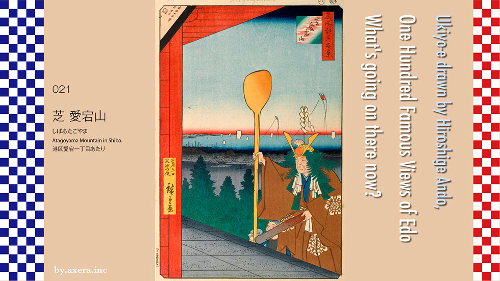
021 Shiba Atagoyama is a picture on the stairs of Atago Shrine, looking toward the sea and now towards Shimbashi Station, using the ladder gate.
First, let's check the position on the old map. There is no name of Atago Shrine on the old map, but it is the name of Betto, that is, the name of the management temple, Enpukuji. I put a red gradation on the place to be the viewpoint and put a modern map on it. Due to its height, Atagoyama was also the place where NHK first set up broadcasting facilities when television broadcasting began, and it is now the NHK Museum of Broadcasting.
Let's take a closer look at the picture from above.
The letters of Ansei 4th year appear in the upper left corner, and a large rice scoop can be seen in the sky, and a kite is flying in the sky, telling us that it is a New Year's scenery. You can see up to Edo Bay, and on the left side of the white sail, you can see the direction of Gyotoku. The slightly large roof that you can see in the city seems to be Tsukiji Hongwanji.
Atago Shrine was built by Ieyasu Tokugawa as a god of fire prevention as a protection on the south side of Edo Castle. The main god is Homusubi no Mikoto, but since the landlord god is Bishamonten, an event called a strong meal ceremony was held on the 3rd of New Year every year.
A messenger of Bishamon wears a samurai dress, a helmet with a new year's decoration such as kelp, fern, orange, and wand with hemp and paper streamers, a surikogi sword on his waist, and a large ladle. I will go down to Enpukuji Temple, which is a separate place with the three of us.
This Bishamon messenger forces people waiting at the temple to eat a heap of rice. It depicts the scene where this the hard boiled rice ceremony is over and just climbed the stairs and returned to Atago Gongen. At the end of the climb is the Niomon Gate, which depicts Edo Bay, which you probably could see far away.
Atagoyama itself is about 26m above sea level, but it seems that the view was quite good because the sea side was a cliff. About 10 years after Hiroshige painted this painting, Italian-born British photographer Felice Antonio Beato was taking a picture from Mt. Atago. If you look at the photo, you can see Hamarikyu Gardens, Odaiba, and Tsukiji Hongwanji Temple. Please see the direction photograph of Hiroshige's painting and the panoramic video of the whole view to the sea.
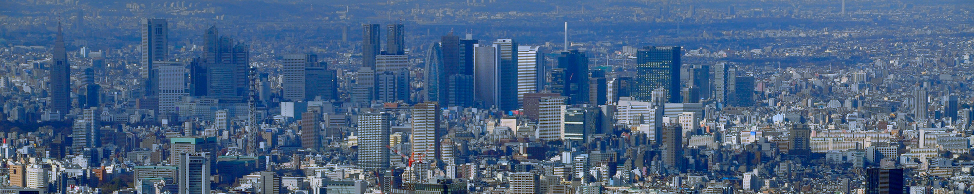
I actually went to this place. As you can see, the trees and buildings that grew up do not allow you to see far away.
The Niomon, which would have been in this area, has been set back later due to several fires and air raids.
This is the front of the current Atago Shrine.
I looked at Atago Shrine from the side.
This is the view from the NHK Museum side without trees. After all, in the building and the new building of Jikei University Hospital, you can't see far away.
This is the view of Atago Shrine from the bottom of the stairs. This tremendous steep staircase is called the "steps of success". The origin is named after the story of Heikuro Magaki in "Kannei Sanbajutsu", which is famous for storytelling.
On the way back from the third shogun, Tokugawa Iemitsu, who came to Zojoji Temple in Shiba, the family temple of the shogunate, he passed under Atago Shrine and ordered his vassals to pick up the plums that happened to be in his eyes.
Among the vassals who flinch at the stone steps that are too steep, only Heikuro Magaki of the Shikoku Marugame Domain climbs the stone steps with a horse and folds the plums on the mountain to Tokugawa Iemitsu. It is said that the plums were presented.
I tried to fit modern photographs into Hiroshige's paintings. Hiroshige will be quite surprised to see this photo. I wonder if I could really see the sea from this place, and I want to go back to the old Edo.
 I actually visited one of my favorite places, One Hundred Famous Views of Edo, drawn by Hiroshige Ando, and what the scene is like now.
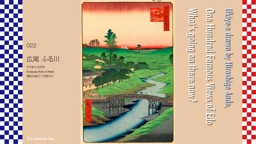
The Hiroo Furukawa of 022 seems to be a view of the current direction of Kitasato University Hospital over the Shinohashi bridge on the west side of Furukawabashi bridge.
First of all, please see the whole picture of Edo in the 4th year of Ansei, the year after this painting was published.
I put a red gradation in the place that becomes the viewpoint of this picture.
Furukawa river in the picture originated from the surplus water from Tamagawa Josui Aqueduct. On the map, from the Okido Mizubansho in Yotsuya on the upper left, pass through Naito Suruganokami's Shimoyashiki (next to the current Shinjuku Gyoen National Garden), Shibuya, Hiroo, Azabu, Azabujuban, and the south side of Zojoji, and then at Kanasugi Bridge. Earlier, It was pouring into Edo Bay. The names were changed one after another to Shibuya River, Furukawa, Akabane River, Shinbori River, and Kanasugi River.
Originally, this Hiroo area was a lonely village because it was located on the southwestern edge of Edo Castle and did not pass through a large highway, even though there was a village of Honmura for a long time. After that, under the policy of the Edo Shogunate, many temples and shrines were relocated to the current Roppongi Azabu area on the north side of Hiroo, and along with that, the number of daimyo residences increased.
Even so, it seems that this area called Hiroohara was used only for general falconry, but after the middle of the Edo period, when it was no longer used for falconry, Edo citizens finally played in the spring, summer and autumn, and listened to insects. As a result, teahouses with reeds were built, and the number of townhouses seems to have increased.
Please take a look at the old map of Tenpo, which is a slightly enlarged version of this area. Maps of the Azabu area and the Shirokane area are combined according to the direction. Azabu Roppongi area, north of Furukawa, is lined with daimyo residences.
On this map, I plotted the main locations so that the positional relationship with the present can be easily understood. With the opening of Japan, temples and shrines in the Azabu area temporarily became facilities in each country, and eventually the daimyo mansion in this neighborhood became an embassy. For that reason, there are many embassies around here.
Zenpukuji Temple in Azabujuban was the US embassy at the end of the Tokugawa shogunate, but Heusken, the secretary and interpreter of the minister Harris, was attacked by the Satsuma feudal lord of the Joui school in Higashi Azabu and became a major incident at the end of the Tokugawa shogunate. Heusken is buried in Korinji next to the French embassy, which is cut off on the right side of Hiroshige's painting.
I tried to overlay this map with a modern map.
Now, let's take a closer look at the picture from above.
The upper part of the picture is a hilly area called Hiroohara, but it seems to be the hill around Ebisu Garden Place, which continues from Hiroo Hospital and Ebisu 3-chome beyond the current Tengenji Temple. The tip of the valley seems to be in the direction of Shibuya Bridge. At the end of the hill, there is a cherry blossom, and in some places, you can see the townspeople playing.
There are several townhouses on the left side, and the big one in the back of the Kakechaya-cafe is Owariya, which is famous for "fox eel", and its name remains on the old map of Tenpo. This Furukawa river is now straight, but at that time it was intentionally meandered to ensure the depth for the vessel to navigate.
The bridges over here are the current Shinohashi bridge. Tradesman-style and samurai-style people are about to cross Furukawa river. At that time, it was also called Sagami-Donobashi bridge because there was a mansion of Tsuchiya Sagaminokami on the right side. The Shinohashi (means fourth bridge) bridge started from the first bridge in Azabujuban and was the fourth bridge, so the sixth bridge is now the Tengenji Bridge.
I actually went to this place. The Metropolitan Expressway Meguro Line runs above, so you can't see it at all.
This is the view from Yakuenzaka in the north direction from Shinohashi bridge. The large building on the left and the embassy of the Republic of Iran are the places where the former Tsuchiya Sagaminokami's mansion was located.
This is the view from Shinohashi bridge on the east side.
This is the view from Shinohashi bridge on the west side.
This is the view from Hiroshige's point of view on the Metropolitan Expressway Meguro Line.
None of them are realistic, so I took a look at the Apple map this time as well.
I tried to fit the current actual photograph into Hiroshige's painting.
This doesn't look too good, so I put in an Apple map image.
In any case, it's easy to see that this area is no longer a place for outdoor play. Opposite the place where the fox eel Owariya was at that time, there is now a yakiniku restaurant, which is very prosperous on holidays.
I actually visited one of my favorite places, One Hundred Famous Views of Edo, drawn by Hiroshige Ando, and what the scene is like now.
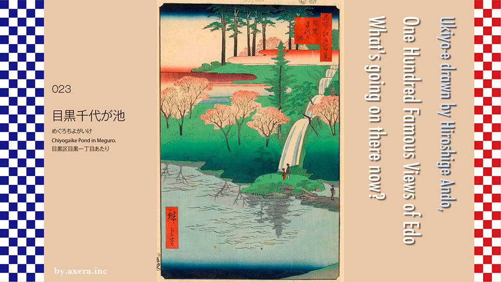
023 Chiyogaike Pond in Meguro is like a view of up hill from the area down the slope of Hotel Princess Garden along Mita-dori in front of JR Meguro station. Even now, from Meguro Station, the west side of Mita Street is a steep cliff, and Chiyogaike is in the middle of the cliff, in the lower mansion of the Matsudaira Tonodo Matsubara feudal lord of Kyushu. It is said that it was there. The plateau around here was called "superb view" because it was a very scenic place where you could see the rice fields from the Meguro River below, the mountains of Tanzawa and Chichibu in the distance, and Mt. Fuji beyond.
At that time, you can see that such scenery, flowers, and the changing seasons were entertainment.
First, let's find the place from the old map. Let's put a red gradation in the place that will be Hiroshige's viewpoint.
This thick road that crosses to the left and right is now Meguro Dori, and at that time it was called Sagami Kaido. Almost in the middle is the current Meguro station, and if you go down Gonnosuke-zaka on the left, you will reach the current Otori Shrine via Meguro Shimbashi. On the right side of the station, you will reach Shirokane 1-chome via Kamiosaki, Nature Study Park, and Miyako Hotel, north of Happo-en.
From Kamiosaki to Shirokane 1-chome, it is said that there were few houses at that time and Tsujigiri(Murder) and oihagi(robber) frequently appeared. The slope called Hiyoshizaka from the north side of the current Happoen to the Miyako Hotel is a particularly dangerous area, and it was also called Hayamichiba because travelers passed by quickly.
Even so, from Meguro Station, if you go down Gyoninzaka, you will find Meguro Fudo, and if you go to the right from the front of Otori Shrine, you will find Yutenji Temple, so it seems that it was crowded with worshipers on the fair.
Mita-dori, which runs north from the station along the Matsudaira family residence, is a hill that continues to Ebisu and Shibuya, and along that hill, Mita Aqueduct that branched off Tamagawa Josui at Kitazawa in Setagaya was flowing. The blue line on the map is the Mita Aqueduct. Perhaps the waterfalls and ponds that appear in Hiroshige's paintings used this water.
Let's take a closer look at Hiroshige's paintings from above.
The first thing that appears is a few pine trees and a few cherry blossoms.
It is said that the origin of this Chiyogaike is the name of the mistress of Yoshioki Nitta, a military commander of the Northern and Southern Dynasties. Nitta Yoshioki, who was chased by Takauji Ashikaga and fled to Musashi from Echigo, will reach the end when he passes the Rokugo on the Tama River. Chiyo, the mistress who received this news, hung the clothes she wore on the pine tree before throwing herself into this pond.
On the right side of it, a waterfall divided into five steps is drawn. According to records, this waterfall is 110m long and 45m wide. I think it's true. Three samurai women are drawn under the waterfall and see the cherry blossoms. Perhaps it is related to the Matsubara feudal lord.
At the bottom of the picture, a large area is occupied and Chiyo is drawn with a pond. Hiroshige draws the same place in "Picture Book Edo Souvenir" after this picture and publishes it. According to the commentary, Chiyo couldn't express the size of the pond in composition, and it was a regret. Looking at the picture, Chiyo is a pond on almost half of the left page. In any case, it seems that it was a fairly large pond.
At the bottom of the picture, a large area is occupied and CChiyogaike Pond is drawn with a pond. Hiroshige draws the same place in "Picture Book Edo Souvenir" after this picture and publishes it. According to the commentary, Chiyo couldn't express the size of the pond in composition, and it was a regret. Looking at the picture, Chiyogaike Pond is a pond on almost half of the left page. In any case, it seems that it was a fairly large pond.
Well, I actually went to that place.
The Matsudaira family's lower mansion is long from north to south, so it is not possible to identify where Chiyogaike Pond. Currently, this Metropolitan Police Department Meguro Joint Government Building is the most promising candidate.
This is a picture of looking up from a little further down the hill.
It's a little further north from the same slope.
This is a photograph of the lower slope of the slope from the Mita-dori side, in the middle of the Matsudaira family's site. I can't see anything.
This is a photo of Meguro Station from Mita Street at the same point.
This is a photo of Ebisu from Mita Street at the same point.
This is a photograph of the north end of the former Matsudaira family site, looking south from Mita Park.
I tried to fit the current photo into Hiroshige's painting.
This time, not only the location of the pond, but even the traces of where the garden and waterfall were were found. Meguro, which has become such a high-class residential area, is undergoing a transformation. Hiroshige, who was concerned about the size of the pond, what does Chiyogaike Pond think when he sees the current location where he does not even know the location of the pond?
 I actually visited one of my favorite places, One Hundred Famous Views of Edo, drawn by Hiroshige Ando, and what the scene is like now.
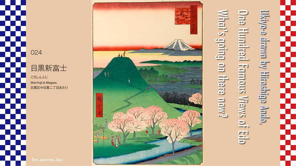
024 Meguro Shin-Fuji is a picture of Mt. Fuji, which was located near Bessho-zaka hill, passing through the shopping street in front of the west exit of Ebisu, along with the real Mt. Fuji. It seems that this was called Shin-Fuji to distinguish it from the other Fujizuka that was in the immediate vicinity. Another Fujizuka is called Motofuji and will be introduced in 025 next time.
First, I searched for the place from the old map. In the Edo period, there were few houses around here, and it seemed to be an image of a cold village, and the map was written fairly roughly. Therefore, I tried to describe both Shin-Fuji and Motofuji, which I will introduce next time. I put in a representative station so that I could get an idea of the location.
Next, I added Hiroshige's viewpoint in gradation to the current map. Red is Shin-Fuji and green is Motofuji. Mt. Fuji is almost west-southwest. Please also refer to the station you entered on the old map.
Fujizuka is a small mountain (artificial hill) created to resemble Mt. Fuji, a sacred mountain, based on the Fuji worship. During the Edo period, it was difficult for ordinary people to actually climb Mt. Fuji, so a group of people who worship Mt. Fuji called Fujiko in various places practiced climbing Mt. Fuji on the opening day of Mt. Fuji (currently July 1). It was. Even today, Fujizuka remains in several places in Tokyo, including the precincts of Hatonomori Hachiman Shrine in Sendagaya and the precincts of Jujo Fuji Shrine.
This area is the river terrace of the Meguro River, which runs from Komaba to Gotanda and beyond Takanawa. It's a cliff, and since Shin-Fuji and Motofuji are on the cliff, even a small mountain can be seen very well, and on a sunny day, you should be able to see far away.
Shigezo Kondo, who explored the Kita Ezo and the Kuril Islands with the help of the Tokugawa Shogunate and later became a Shomotsu Bugyo, lived in Nihonbashi Kakigaracho. In the second year of Bunsei (1819), Yarigasaki in Mitamura created a new Mt. Fuji on the site of a separate house with the help of the people of Fujiko. It is said that its size was 12m in height and 300m in circumference.
At the foot of the "womb cave" modeled after the actual lava tube at the foot of Mt. Fuji, and with the shrine and stone monument of Miroku Gyoja, who became the ancestor of the revival of Fujiko in the middle of the Edo period, It was set up and became a major tourist destination in Edo.
Let's take a closer look at the picture from above.
First of all, you can see Mt. Fuji, which is still snowy, over the mountain. In the foreground, it seems that the left is Mt. Oyama and Tanzawa, and the right is around Mt. Jinba.
This photo is currently Mt. Fuji seen from Tachikawa, but I think it is almost the same as the view seen from Meguro at that time, although the angle is about 5 degrees different. In reality, I can imagine that I could see from Meguro to around Chichibu.
From the top of Shin-Fuji, three townspeople are looking at Mt. Fuji and talking about something.
There is a green forest under the yellow haze cloud, but it seems that the cultivated land that looks black in the forest that leads to Yutenji is around Nakameguro Station on the Tokyu Toyoko Line. At this angle, you should be able to see the Meguro River, but it may have been cut in comparison with Mita Aqueduct. On the mountainside, you can see the shrine of a worshiper and a monument made of fossil camphor tree that Shigezo Kondo brought back from Ezo. On the left side of the road, on the approach to the zigzag, there are three Fujiko followers who are aiming for the summit.
At the bottom of the picture, the Mita irrigation water that branches off from Tamagawa Josui flows around the mountain. It seems that the shore of this Mita Aqueduct was also a promenade. On the shore, families are playing under the cherry blossoms in full bloom. At the teahouse with wisteria vines on the left, a man from a tradesman who is climbing up and a woman who looks like a samurai wearing a haori coat are depicted, probably because it is still cold.
Well, I actually went to this place. Shin-Fuji has already been destroyed, so I don't see it, but this is a photo of Mt. Fuji from the top of Bessho-zaka hill. Surrounded by trees and buildings, you can't see at all.
This is a signboard for Shin-Fuji installed locally by Meguro Ward. Recently, the underground remains of Shin-Fuji and the statue of Dainichi Nyorai were discovered. It is said that it is now backfilled underground.
At the exit of Bessho-zaka hill, about 6 Koshinto towers, which were probably made by Koshinto's friends, were enshrined. Koshin is a practice that on the night of Koshin-day, which comes once every 60 days, insects that report wrongdoing to heaven wake up all night to prevent them from entering the body.These statues were made around 1665-1764.
This is a photo from a little down the Bessho-zaka hill. Again, the outlook is bad.
This is a photo of Shin-Fuji looking up from the bottom of Bessho-zaka hill. At that time, a 12m small mountain was rising above this.
It is a stone monument of an old road sign that is located across Mita Street from the west exit of Ebisu Station through the shopping district. The front is engraved with Namu Amida Butsu, and the left side is engraved with "Left Fudoson Michi" and the right side is engraved with "Right Yutenji Michi". This is a place where the old road from Hiroo breaks up, and if you go to the left, you will go to Meguro Station and Meguro Fudo, and if you go to the right, you will go down Bessho-zaka hill to Yutenji. Right.
I tried to fit the current photo into Hiroshige's painting. What do you think?
In reality, this is too different from Hiroshige's image, so I combined the Applemap and Mt. Fuji images, making the most of the original image, and fitting it in.
Hiroshige's Shin-Fuji was also written quite exaggeratedly, but the 12m-high Shin-Fuji is more than double the height of the high-rise condominium in front of Nakameguro Station. Hiroshige will laugh at this.
 I actually visited one of my favorite places, One Hundred Famous Views of Edo, drawn by Hiroshige Ando, and what the scene is like now.
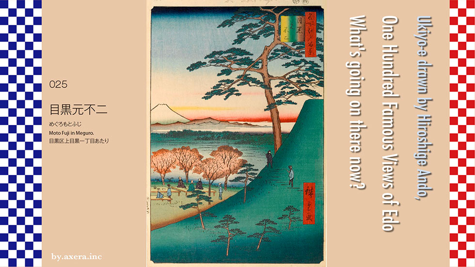
025 Moto Fuji in Meguro is a drawing of Mt. Fuji and the actual Mt. Fuji, which was located behind the Hillside terrace on the old Yamate-dori in Daikanyama.
First of all, I searched for the place from the old map of the time of Tenpo. I am using the map with 024 Shin-Fuji introduced last time. In the Edo period, this area had the image of a lonely village with few houses, and only its location is roughly written on the old map. I tried to describe both Motofuji and Shin-Fuji introduced last time. I put a representative station in it so that I can understand the relationship between the places.
Next, I added Hiroshige's viewpoint in gradation to the current Google map, which has almost the same scale as the old map. Red is Shin-Fuji and green is Motofuji. Mt. Fuji is almost west-southwest. Please check the plot of the station on the old map again. This should give you an idea of the actual positional relationship.
By the way, I tried to find out why two small mountains like Mt. Fuji were built in such a neighborhood.
In Fujiko, the trainees who trained on Mt. Fuji with the folk religion established in the Edo period lead the followers of Fujiko in various parts of Edo to Mt. Fuji. The program was to go to Fujiyoshida, cleanse yourself, and then be taken by a leader called the Oshi to climb Mt. Fuji. However, there were various difficult problems such as huge cost, physical strength, number of days, and bills of passage. Under these circumstances, one of the trainees who had been practicing rigorously was a trainee named Ibei Ito, who was born in Mie and was a tradesman. In his training, he was active under the name Jikigyo Miroku and was called "Beggar Miroku" because he extended his teaching to the poor common people.
18th year of Kyoho (1733) When Jikigyo Miroku was 63 years old, he left his home in Komagome and fasted at the 8th station of Yoshidaguchi, Mt. And on the 35th day, I was accepted. In other words, he died and became a Sokushinbutsu (mummy) himself. This sensational event made Fujiko known all over Edo City at once.
Takada's garden tree craftsman, Tohshiro, who calls this Jikigyo Miroku a teacher, applied for it in the year of his 33rd anniversary, and 14 years later, in 1779, the first in Edo. Fujizuka will be completed at Mizuinari Shrine in Waseda. Tohshiro kept the sentence left by his teacher and created Mt. Fuji, which even women and children can easily climb. As a result, Fujiko, which was a part of the new religion at that time, became popular in Edo at once, and miniature Mt. Fuji was created here and there in Edo. At that time, it seems that there were so many lectures in Edo City that it was said to be 808 lectures.
Currently, there are seven Fujizuka in Tokyo, three of which are designated as national important intangible folk cultural properties.
It is said that this Meguro Motofuji was built in 1812 by the ancestors of the Fujiko called Iemon in front of the Azabu Zenpukuji gate, and the followers of nearby villages such as Azabu, Shiba, and Kamimeguro. It is said. There is Sengen Shrine at the top, and the height is about 12m, so that people can easily go up and down. Seven years later, Shin-Fuji was built, so it became known as Motofuji, and both were on a hill with a very nice view, so it is said that people other than Fujiko also visited for sightseeing and were very busy. I will.
Now, let's take a closer look at Hiroshige's paintings from above.
First of all, a pine tree appears. In fact, the record states that there was one pine tree with good branching. Including that, the sky is also large, and Mt. Fuji without color appears at the same height as Fujizuka. The mountain in the foreground seems to be Mt. Jinba and Tanzawa. Below the white haze cloud, it seems that the direction from the present Higashiyama to Ikejiri and Sangenjaya.
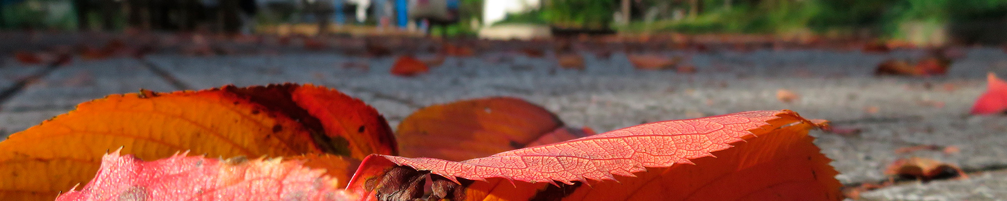
On the mountainside, two men standing in the crotch and hood with a haori are talking while looking at Mt. Fuji. Under the colored maple or Japanese maple, we love the scenery and enjoy the autumn leaves hunting on the floor.
Actually, this place is on a hill, so on a sunny day, it seems that you could see quite a bit.
At the time of the first rub, Mt. Fuji had no snow and turned into maple and autumn leaves, but after that, snow was drawn on Mt. Fuji, and maple became the color of a cherry tree.
Hiroshige also draws the same Motofuji in the picture book Edo souvenirs. This composition is Motofuji seen from the southwest side, and is titled Meguro Motofuji Shitamichi. Similarly, a pine tree is drawn on the mountainside, and a maple is drawn in the foreground. However, the height difference of the land is not reflected very much.
I actually went to the place of this picture.
Fujizuka has not been destroyed. A large condominium was built in the original place, and the wooded area underneath is the Tokyo College of Music. The eastern slope of this place is where the Tokyu Toyoko Line goes to Nakameguro Station and appears on the ground. You can still see Mt. Fuji next to the building on a sunny day.
If you look at the photos that are a little closer, you can certainly see Mt. Fuji.
This is the exit of the cut-off slope. It is an old road that goes down through Aobadai and joins Oyama-Okan, that is, the current Route 246.
This is a picture of the Daikanyama side. After this, you will pass through Hachiman Dori and reach Namikibashi.
I tried to overlay the current scenery on Hiroshige's painting. What do you think? Well, this is fine, though.
It's too different from the original picture drawn, so I combined the Applemap and the picture of Mt. Fuji and fitted it into Hiroshige's picture. How about this?
Even so, I think it's a little too bold compared to the existing Fujizuka. In any case, it seems that it was effective enough to attract tourists at that time.
 I actually visited one of my favorite places, One Hundred Famous Views of Edo, drawn by Hiroshige Ando, and what the scene is like now.
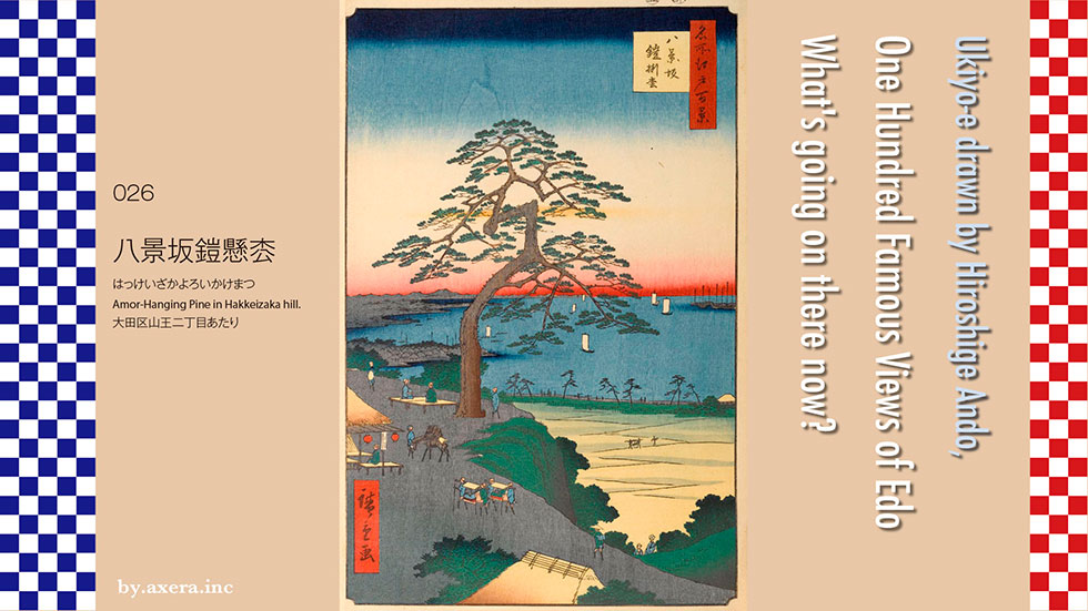
The 026 Amor-Hanging Pine in Hakkeizaka hill on Ikegami-dori near the west exit of JR Omori Station and the scenery beyond it.
First, I searched for an old map, but since this area was not Edo at that time, there is only a suburban map. The Tokaido that left Edo Nihonbashi crosses Takanawa Okido, and when you go to the right at Minamishinagawa, ahead of Shinagawa, you will reach Ikegami-dori. I crossed and joined the Nakahara Kaido. The blue line on the map is Tokaido, and the green line is Ikegami Road. As Hiroshige's point of view, I added a red gradation.
The big pine tree in the picture was on Ikegami-michi, Hakkei-zaka, about halfway between Oi and Arai-juku. Actually, Ikegami-dori is also a steep slope, but it seems that it was steeper at that time. When it rained, it was dug like Yagen, which makes medicine, so it seems that it was called Yagenzaka at first, but when I chose the scenic eight scenic spots in this area, Hakkeizaka means scenic. It came to be called.
Also, according to Kunio Yanagida, there is a theory that it may have come from "Hake (cliff)" which means the edge of the hill.
Travelers who pass through Shinagawa-juku on the Tokaido and come straight to Tachiaigawa and Suzugamori will find a large pine tree on the hill on their right. There are two pine trees, the larger one is 800 years old, about 20 meters high, the branches hang down like a willow, and the trunk is thick enough to hide one cow. The pine then died by the end of the Meiji era, but it seems that the stump could still be seen for a while. Furthermore, in the Taisho era, a house called Shigeki Tanaka was built in this place, and it seems that the pine trees and the scenery beyond them could not be seen.
When Yoshiie Hachiman Taro, a military commander of the Heian period, was conquering Oshu and headed for the role of Mr. Abe in the War of previous nine years, he stopped by the Tenso Shrine opposite this pine tree to pray for victory. It was this pine that ware hanging armor at that time, so this pine came to be called Amor-Hanging Pine.
This old map is quite different in scale and direction, but I forcibly overlaid the modern map. I think you can roughly understand the position and direction. It is a picture of the north-northeast from the front of Omori station.
Hiroshige draws the same place several times. First is the picture book Edo souvenir. Although it is in a horizontal position, it has almost the same composition as the One Hundred Famous Views of Edo, and the shape of the pine tree and the swing of the branches are almost the same. Shinagawa is not drawn, but the Boso Peninsula is drawn small.
Next is Totozaka Zukushi. Here, both pine trees are drawn, making it more realistic. Many people come and go, and Tokaido and Shinagawa-juku are also drawn. The shape of the pine is quite squiggly, but I'm a little skeptical that it was actually like this.
Next, I compared the first print and the second print of Hiroshige's the One Hundred Famous Views of Edo. The usage of hue and gradation is slightly different. The post-printing is darker overall, more vivid, and more flashy.
The last is the evening view of Hakkeizaka, a picture of famous places in Edo. This is drawn very dynamically, and it is drawn quite realistically, such as the state of the teahouse, the tourists coming in Kago, the line below, and the party of the lecture returning from the ceremony Oeshiki in Honmonji Temple. I will. This picture is drawn mainly by people, and the pine tree itself is a gentler way of drawing than others, so it may have been like this in reality.
Now let's take a closer look at the picture from above.
First, the sky occupies nearly half the area, and large pine trees appear. As described, you can clearly see the situation where the pine trees are hanging down.
Boso can be seen beyond Edo Bay, and Mt. Tsukuba is drawn beyond that. Below that is the cityscape of Edo. Furthermore, the peninsula that juts out into the sea below becomes Shinagawa-juku.
In Edo Bay, there are several boats with white sails and several boats on the right. A blackish pine forest is drawn on the beach, but this is the Tokaido, and even the traffic of people is drawn.
At the teahouse on the left, there are people who are resting, people who are chatting on the floor, two travelers, a trainer and a horse, two groups of tourists who came on a kago, like Hiroshige, at that time. People's lives are depicted.
In the yellow lowland on the right, a small figure of a person riding a kago and a person walking is drawn. This seems to be around the current Tachiaigawa. From the bottom of the cliff, there are two people who are climbing right now, but these are the ones who are climbing from the east side to the west side of the current Omori station. There is also one person who climbs the slope from the direction of Honmonji Temple and heads for Shinagawa.
The yellow roof at the bottom is like a teahouse, but considering the appearance of the trees, it may be that the Tenso Shrine in front of it was drawn.
Well, I actually went to this place.
This is a picture taken from the entrance of Tenso Shrine. At that time, I guess I could see from here to Boso.
This is a photo of Ikegami-dori and Oi.
This is a photo of Ikegami-dori and Ikegami.
It is the west exit of Omori station seen through Ikegami street.
This is the Tenso Shrine opposite the station, where Yoshiie Hachiman Taro prayed for victory.
This is the direction of Hiroshige's point of view as seen from the side of the approach to Tenso Shrine.
I tried to fit modern photographs into Hiroshige's paintings. The vestiges of those days are not wonderful. There are various buildings such as the station on the cliffside at that time, so it can't be helped.
 I actually visited one of my favorite places, One Hundred Famous Views of Edo, drawn by Hiroshige Ando, and what the scene is like now.
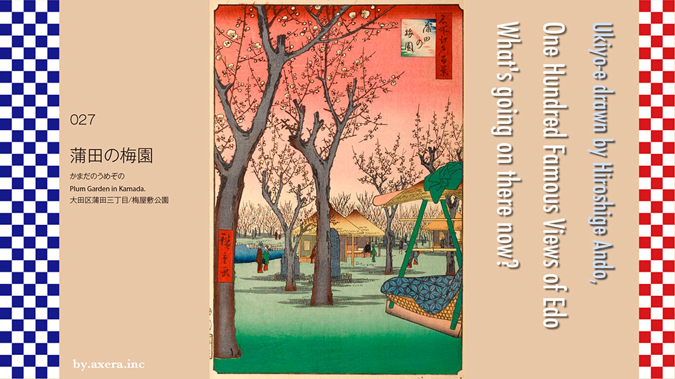
Plum Garden in Kamada in 027 is a rhythmic drawing of the drugstore's plum garden, which was located between the current Keihin Kyuko Umeyashiki Station and Keikyu Kamata Station. After some twists and turns due to road maintenance and Keikyu line maintenance, a part of it is now left as the ward's sacred site Kamata Umeyashiki Park.
When farmers in the Omori area struggled to pay their annual tribute, they realized that the land around them was suitable for growing plums. Therefore, in order to add even a little annual tribute, we cultivated plum trees and made the plum fields large enough to be called plum grove, and became a specialty of Omori, which is as famous as seaweed.
There were three shops selling Chinese herbal medicine called Wachusan in Omorimura Nakahara, Yato, and Minamihara on the Tokaido. This picture is the scenery of Omori drawn in "Edo Meisho Zue" (edited by Gesshin Saito, Tenpo year). Wachusan is a stomach medicine that contains loquat leaves, Keishi, cinnabar, wood scent, licorice, etc., and is effective against heat, dizziness, colds, etc. It was a regular medicine.
This Wachusan was born in Umenoki Village, Ritta District, Omi Province (currently Rokujizo, Ritto City, Shiga Prefecture). There is a good report that he recovered, and the name of Wachusan was named by Ieyasu at this time. The building still remains in Shiga as an important cultural property as the former Wanakasan Honpo.
The place name of this birthplace is Umenoki, and since the ume tree was planted in the splendid garden of the original Wachusan store, the three houses in Omori also used the ume tree as a signboard. The store in Minamihara was bought by Yamamoto Chuzaemon in Kita Kamata and moved to Kita Kamata. Eventually, his son, Kyusaburo, built a pond and Azumaya(resting place) in the continuation of his garden, planted a lot of plums that showed flowers and branches, and built a "rest teahouse." This situation was left at the Edo Famous Places. Hiroshige is also drawn with a picture book Edo souvenir.
Originally, farmers did not need old trees because the purpose was to harvest plum fruits. Kyusaburo bought an old tree with good branching and transplanted it to create a splendid plum grove in his garden. At that time, along with Kameido Umeyashiki, it was a famous spot for plum blossoms in Edo. However, unlike Kameido Umeyashiki, this Umebayashi was intended to sell medicine, so I was free to enter the Baien and enjoy the scent of Umemi (Plum viewing) and Ume to the fullest in Azumaya(resting place).
Now, let's take a closer look at the picture from above.
First, it starts with the red gradient of the sky. Is it a plum color that imaged early spring? A well-maintained plum with good branching appears there. Compared to The Picture book Edo souvenir painting, you can see that the plum trees are in good condition.
Kago is drawn on the middle right. This is called a YamaKago, and it is a Travel Kago, and did travelers stop by from the Tokaido?
Azumaya and the stone monument that probably carved the song are rhythmically arranged, giving a sense of perspective, and you can see that the plum tree continues all the way to the back. Tourists and travelers are resting in Azumaya and are now enjoying plum blossoms. It's like the scent of plum blossoms. The texture of the rugged, old plum trees is often seen, and the pond is on the left.
If you look closely at the green bamboo Kago on the right side, you will see a bellflower-patterned travel feather on a plaid cushion. You can feel the image that the trip to Kago at that time seemed to be interesting.
When I searched for a map of the suburbs of Edo at that time to find out where this place was, there was a proper notation of Umezono and Wachusan. The blue and red circles are that. Even if you look at this map, you can see that this place was quite famous at that time.
See the location on a modern map. Although the scale has been reduced now, it has been preserved as the ward's sacred site Kamata Umeyashiki Park.
I actually went here. It is in front of the south side of Kamata Umeyashiki Park. The later white building is the Keikyu viaduct.
The stone milestone, which is said to have actually existed, was also restored. It was inscribed as "Kamata Village Yamamotoya, Sanri Juhachicho, Nihonbashi".
The current Umeyashiki Park does not have a pond or Azumaya, but it is in good condition. I wanted to visit during the actual plum season.
The Daiichi Keihin National Highway, which has a lot of traffic, runs right next to it. This is the Tokaido at that time.
I tried to fit the actual view of the garden into Hiroshige's painting. It is a place where such scenery remains, which is rare in the series of famous Edo 100 views. It's cute that the YamaKago looks a little floating.
 I actually visited my favorite one hundred views of Edo drawn by Hiroshige Ando and what the scene is like now.
028 Gotenyama Hills in Shinagawa is a view of the direction of Gotenyama, that is, the current direction of Osaki, from a little south of the Yatsuyama Bridge overpass in the south of Shinagawa Station, which is famous for Hakone Ekiden.
First of all, I prepared a map of the time to confirm the location. Considering the road conditions that are still the same, try tilting the whole so that the north is on top. The river that flows from left to right is the Meguro River. The slightly thick and yellow road that runs from top to bottom is the Tokaido. At the intersection of the Tokaido and the Meguro River, the area on the left is the current Keikyu Shimbamba Station.
I put a red gradation in the place that would be Hiroshige's point of view. You can see the words "Gotenyama, Sakurano Famous Place".
I overlaid the modern Apple map on this. It looks like the view from the condominiums in the south of Shinagawa Joshi Gakuen on the current Daiichi Keihin National Highway.
Since I don't understand the situation at that time on this map, it may be a little off, but I tried to cover the light blue of the sea and the red Tokaido at that time on the modern map.
This Gotenyama was a hill overlooking Shinagawa Minato, which prospered alongside Asakusa Minato, when Ota Dokan set up the castle during the Choroku era (1457-1460) before entering Edo Castle. After that, after Ieyasu Tokugawa entered Edo Castle, Gotenyama Castle was called "Shinagawa Goten" and was a resting place for successive shoguns falconry. However, in February 1702, the palace was destroyed by a fire that broke out at Taisoji Temple in Yotsuya. Since then, it has not been rebuilt, and the eighth shogun Yoshimune transplanted about 600 Yoshino cherry trees to this lawn mountain, and Gotenyama was maintained as a famous place for cherry blossoms with an area of 11,500 tsubo (38,016 square meters).
In particular, this mountain had a flat top and looked like a lawn square, even though it was surrounded by cliffs. Moreover, it is close to the sea, and it became popular to see the mountains of Chiba on the opposite bank at the end of the ship sailing with white sails. It was. In the 6th year of Kyoho (1721), some people drank alcohol and went on a rampage, so even a bill was issued to prohibit the fuss. This news is similar to modern Ueno Park.
In the 6th year of Kaei (1853), Perry arrived from the United States and asked the shogunate to open the country, and the Edo shogunate felt threatened by this, and 11 to 12 Daiba batteries were off the coast of Shinagawa for the direct defense of Edo. I made a plan to build (Battery). Construction is proceeding at a rapid pace, and by the time Perry arrives for the second time in 1854, the total construction cost will be about 750,000 ryos (about 2.25 billion to 3 billion yen), and the first, second, third, fifth, and sixth Daiba(Battery) is completed. At this time, because it was easy to transport, the soil used for landfill was procured by cutting down Gotenyama and the Takanawa Yatsuyama that connects to it. In addition, there is a record that Takanawa-dori on the Tokaido was closed during the day and a detour was used for that purpose.
Perhaps because of the effect of Odaiba, the Perry fleet returned from off Shinagawa to Yokohama and landed there, but in Shinagawa, supported by the Odaiba development economy, it showed a great economic excitement, while the citizens of Edo The famous place for cherry blossoms, which is a place of relaxation, has been greatly reduced. This Hiroshige painting depicts a famous place for cherry blossoms that has been greatly shaved into a cliff from the Tokaido side.
This is a detailed map of Shinagawa in 1884. You can clearly see the position and condition of Daiba(Battery). Today, Daiba No. 3 is open to the public as Daiba Park under the Rainbow Bridge, and Daiba No. 6 remains next to it instead of being connected to the ground. Goten Yamashita Daiba was built at the foot of Gotenyama instead of the fourth Daiba, which was canceled on the way, but it is now being reclaimed and is now Shinagawa Ward Daiba Elementary School, Daiba Nursery School and housing.
Let's take a closer look at Hiroshige's paintings from above.
First of all, the green pine and the cherry blossoms of different colors are drawn as if nothing had happened. It seems that the common people of Edo are gathering and enjoying the cherry blossoms together.
If you look in the middle, you can see that the cherry blossom garden is a steep cliff. People climbing the zigzag slope to see the cherry blossoms are also depicted. On the right, some people are walking along the cliff in the direction of Yatsuyama.
At the bottom of the picture, maybe a river created after removing the soil, a bridge is built, and some people walk from the Tokaido area to see the cherry blossoms.
Well, I actually went to this place, but I can't see it at all because it's surrounded by buildings. It seems that the common people are looking at the remaining cherry blossoms in the picture. The Gotenyama Trust Tower is visible in the back, and the Gotenyama Garden is in the foreground.
This is the direction of the Myanmar Embassy, which turned its point of view to the west.
This photo shows Hiroshige's point of view from the top of the mountain. The front is the Shinkansen and JR railroad tracks, which correspond to the cliff drawn by Hiroshige.
This is a photo of going down the cliff and looking toward Kawasaki on the old Tokaido. At that time, this left side was the sea.
I tried to fit the current photo into the actual picture. There is no point in putting the walls of the building, so I put in a picture of Gotenyama Garden. In any case, there is no vestige of that time.
In the seven Edo souvenirs, which are said to have been drawn by Hiroshige during the Kaei era, the scenery drawn from the top of Gotenyama where the soil was taken is left. The explanation of this picture says something like this. I had drawn the same picture before, but after that, the Shogunate carved the soil of Gotenyama and built Daiba in the sea to prevent Kurofune. As a result, the appearance has changed from before, so it is said that I drew this picture again for reference. However, Daiba(Battery) is not drawn in this picture. The original picture of this picture has the seal of the picture of Hiroshige brush.
At the 53rd Meisho Zue in the second year of Ansei, which published One Hundred Famous Views of Edo, I drew Gotenyama seen from the opposite side in the same way. However, this time, along with the houses in Minami-Shinagawa, Edo Bay and several completed Daiba(Battery) are drawn.
However, at One Hundred Famous Views of Edo, a new Gotenyama that emphasizes cliffs is drawn from the sea side. Even if it is sharpened considerably, it will not change as a famous place for cherry blossoms, and it is said that this new cliff itself is a new famous place. Why didn't Hiroshige draw a distant view of the sea from the top of the mountain?
I think that I may have been scolded by the Shogunate for drawing up to Daiba for military purposes at the 53rd Meisho Zue. Just in March of the third year of Ansei, when this painting was published, Hiroshige himself dropped his hair and changed the seal of the painting from Hiroshige painting to Hiroshige brush.
Hiroshige might have thought that a new era that would soon come was coming to this country and to himself.
 I actually visited one of my favorite places, One Hundred Famous Views of Edo, drawn by Hiroshige Ando, and what the scene is like now.
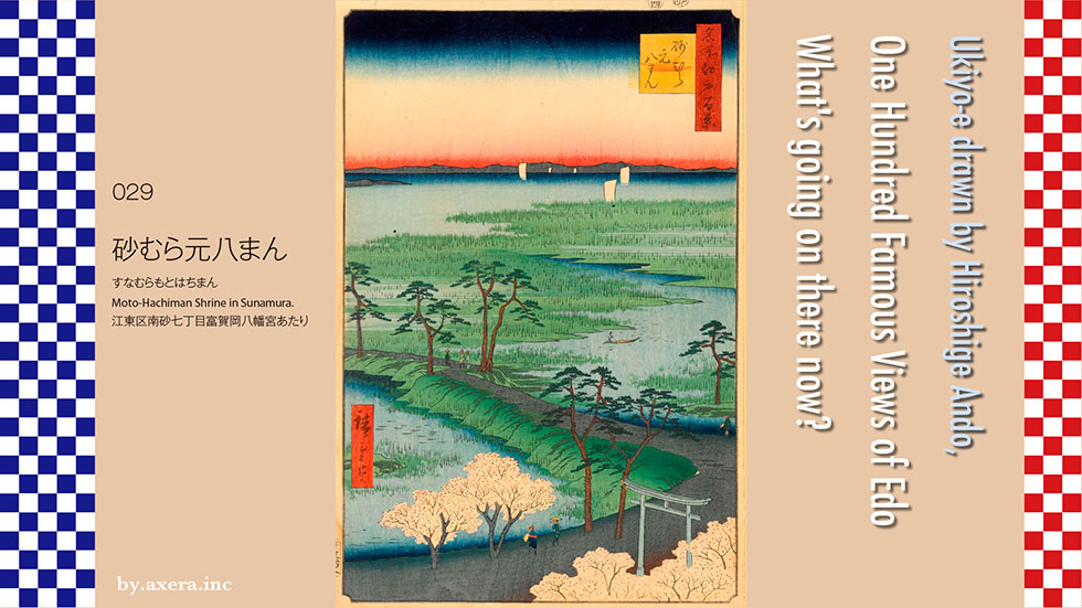
029 Sunamura Motohachiman is a picture of the sea in the direction of Chiba over the torii gate of Tomigaoka Hachimangu, which went east from Minamisuna Station on the Tokyo Metro.
First, in order to confirm its location, I searched from an old map of the Edo period, but since this is also a suburb, there is only a rough map of the surrounding area. Even so, the characters are upside down, but from the bank of Nakagawa river on the right side of the center, you can see that Hachiemon, Sunamura, Otsuka, Nakata, and the village of Shinden (newly reclaimed rice field) name are lined up. You can also see that this area is still under development and the sea was just south of it.
Sunamura Shinzaemon, who was born in Sabae City, Fukui Prefecture, in Echizen Province, learned the technology of Shinden (newly reclaimed rice field) development while being involved in civil engineering projects locally, and after succeeding in the project in Settsu Province, now Osaka Fukushima. , he will come to Edo for nationwide expansion.
In this area, which I worked on with my sons in the early Edo period, the small island was called Horokushima, and after that, reclamation progressed and Sunamura Shinzaemon worked on Shinden (newly reclaimed rice field), so it is called "Sunamura Shinden". It was. After that, Sunamura became a Sunamachi town and was divided into Kitasuna, Minamisuna, Higashisuna, and Shinsuna. The place Hiroshige drew is around the current 7-chome, Minamisuna, Koto-ku.
If you look for a detailed map of this area, the era will advance until the 14th year of the Meiji era. The red circle on this map is the location of Tomigaoka Hachimangu, which is Hiroshige's painting.
I enlarged the map a little more. The red circle is Tomigaoka Hachimangu and the yellow circle is Suzaki Benzaiten. It is described that there was 18 towns from Tomigaoka Hachimangu Shrine about the present Susaki Shrine. The left side of this is the Ito-Yokado Kiba store. In the Edo era, there was a seawall just south of the shrine like Hiroshige's painting, but by this time, a new embankment was built on the south side.
I tried to overlay the modern Apple map roughly to the scale of this map. I also added a red gradation that is Hiroshige's point of view. You can see the current positional relationship.
Around the same time, Gekkin Saito drew this place from the sea side at the Edo Meisho Zue. On the left and right, the word "Yatake Ooshi(many)" is the bamboo used for bows, which is said to have been planted by 8th Shogun Yoshimune. You can see that the seawall is quite high and there are stairs in front of the torii gate. In the middle left, you can see something that looks like Fujizuka.
This shrine was built in 749 and has a long history, but it suffered from repeated floods and salt. In the 6th year of Kaei (1629), the statue of Hachiman, a god that was passed down to Ota Dokan via Chiba clan and Uesugi clan, was moved to Fukagawa by Chosei Houin from Kyoto, and Tomioka Hachimangu was built. It is said that it came to be called Moto-hachiman.
Even so, as the general guardian of Sunamura, it was popular with the local residents and the citizens of Edo, along with the nearby Fujizuka Mound, which is famous for its pine trees and cherry blossoms, and the faith of Fujizuka.
Now, let's actually look at Hiroshige's picture from above.
The mountains of Boso can be seen beyond the white sails floating in the idyllic Edo Bay. Perhaps Ashihara is in the foreground, and it is drawn all over using three colors of green.
In the middle of painting, citizens love pine trees while walking along the embankment in a boat that seems to be heading for Gyotoku and a pleasant sea breeze. You can see that the embankment itself is quite high and filled with soil.
At the bottom, is it a traveler wearing a hat in a row of cherry blossom trees? The two of us will proceed toward the shrine. For some reason, the torii is drawn, but the shrine is not visible. Since the front and back of this field was as far as the eye could see, it seems that we could see the area around Kinshicho, which is quite far away.
A photo of Hachiman Sunamura appeared in a book published in the Taisho era called "One Hundred Famous Views of Edo, a Contrast of Now and Old". According to the commentary, it seems that the famous pine tree was damaged by the tsunami the year before the shooting, and you can see it by looking at the winding pine tree on the left side. It seems that there were three pine stumps in front of the torii gate, and it is written that around this time, the area was still not blessed with drinking water and was carrying water from other sources.
I actually went to this place.
This is a picture of the front of Hachimangu from the south. Ginkgo trees were planted instead of pine trees.
On the left side of the front, there was a monument, a commentary version of the history, and a daffodil that was given by Sabae, the birthplace of Sunamura Shinzaemon.
In the back was the popular Fujizuka, where the followers of Fujiko were gathering at that time.
The torii gate is not visible in the shadow of the building, but this is the view from the current road toward Chiba. Hiroshige's paintings have a slightly higher perspective.
I tried to fit the current photo into the actual picture.
However, this does not make a picture, so I put in a picture taken from the back of the shrine.
How was it? This Motohachiman was built on a small island called Horokushima from the 7th century, but did it move to Fukagawa just because of the flood damage that should have been known? I think there was some other reason because the real reason for this was not clear.
There may be something that Hiroshige did not draw the shrine.
 I actually visited one of my favorite places, One Hundred Famous Views of Edo, drawn by Hiroshige Ando, and what the scene is like now.
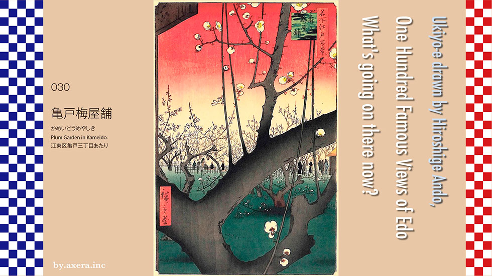
The 030 Plum Garden in Kameido depicts a famous place for plum blossoms, located about 400 meters north of Kameido Tenjin. Along the Kitajukken River, there are about 300 plum trees on all sides of the four towns, and it was named "Seikoan" because of the scent of flowers, but people call it "Umeyashiki". It was exposed. Originally the villa of Iseya Hikoemon, a garment dealer in Ishihara, the villa was later purchased by a wealthy farmer, Kiemon, and became a famous place for plum blossoms that can be heard in the east and west.
Among the plums planted in the park, there is one plum that looks like a dragon wrapped around a dragon and lying down, and people called it Wolong plum and gave it special attention. Although the height is about 3 meters, the thickness of the root is about 1.6 m, and the branches go in and out of the ground on all sides like a dragon winding around, and it is said that the surrounding area was about 11 m. I am. The flower is light red and there are records that the scent was exceptionally good.
Named to mean that the dragon is lying on the ground, this Wolong Plum was named Mitsukuni Mito, the so-called Komon-sama, and it is said that the so-called was written on the Kosatsu (notice board) that can be seen slightly on the left side of Hiroshige's painting. I am. Yoshimune Tokugawa, the eighth shogun, gave the name of Yotsugi Ume (inherited plum), and praised it as "If you grow a root from a branch and become a young tree again, it should not die even for all ages." It is said that two baskets of plum fruits were put into the Edo Castle Honmaru and Ninomaru every year.
Another thing that makes this painting famous is that it was copied by the Impressionist master Van Gogh 30 years later. There is a theory that this Hiroshige ukiyo-e was used on the wrapping paper of pottery sent from Japan to Paris, and Van Gogh who happened to see it copied it in 1887, but it is not clear. This painting, which even has gold nail style kanji on the left and right, is currently in the National Museum of Vincent van Gogh in Amsterdam.
Hiroshige also left a picture of Kameido plum garden in the picture book Edo souvenir. This is a picture of the entire plum garden, with bower and a bench, but you can see that it wasn't inside the plum garden. This area is different from Kamata's plum garden for the purpose of attracting people.
It is said that people visited here from a very chilly time before the plum blossoms bloomed in spring, and there were generally many elegant person, smart people, and hermit. Instead of having a banquet like under the cherry blossoms, it was a social place for adults to take a quiet walk and enjoy the plum blossoms and fragrance.
The plum blossoms give off a nice scent, so I call myself Seikoan. The old tree, which looks like a dragon lying down, becomes newer as the years go by, and I have never heard of the liveliness of this flower when it is in full bloom. When this picture book is explained to a modern translation, it seems that this is written.
The flood caused by the heavy rain in 1910 flooded almost the entire area of Kameido, Ojima, and Sunamura. At this time, this plum grove will also be seriously damaged. Many trees have damaged their roots and withered, and from around 1916, factories were lined up around them, and it seems that the smoke caused further damage. A photo of this place appeared in a book published in 1918 called "One Hundred Famous Views of Edo Past and present".
In the commentary, Wolong Plum, which has been hurt by several floods and road maintenance, still has a savory scent all over the city. However, it is unfortunate that as a factory site, the soot is getting thicker and the plum trees that like clean air will last for a long time.
Let's check this place on an old map. This place is on the map of the time of Tenpo. It is a place written upside down from Umeyashiki. I circled it in red. I will overlay the current Apple Map on this. It's a little out of position, but I think you can get a rough idea of where it is.
Let's look at Hiroshige's painting from above.
First of all, the plum blossoms that bloomed in a well-balanced manner are arranged in the gradation of the red sky. Making the sky red is a tradition of ukiyo-e from Utagawa Toyoharu onwards, which creates the sunset sky, not the plum blossoms. On the upper left is a kosatsu with the origin of Wolong Plum.
In the middle of the picture, a large and thick plum tree crosses diagonally, and on the other side, the plum tree continues all the time. People who enjoy plum blossoms sitting on the floor and people who walk around are depicted, but they are all outside the fence that separates them from the plum grove.
At the bottom of the picture, there is a dark green ground that contrasts with the sky, along with more winding, rugged plum trees. If you look closely, you can see that the base of the tree has a gradation called a Atena-blur, which gives depth to the entire image. The white of the three-wheeled plum blossoms that bloom in it is very well emphasized.
Well, I actually went to this place.
Now this place has become a taxi company, its garage, and numerous homes. The remnants of plum garden do not leave any dust. It seems that all the plums themselves died in 1920.
On the sidewalk facing Asakusa Dori, there is a monument of Wolong Plum and its commentary version.
This is a photo of the Nakagawa area seen from the Wolong Plum monument. The left is the Kitajukken River.
This is a photo of the Asakusa area seen from the Wolong Plum monument. The Kitajukken River is on the right, and the Tokyo Sky Tree stands on the left.
A small old plum tree was planted alongside the commentary version beside the Wolong Plum monument.
At the very least, I put a picture of this plum tree in Hiroshige's painting. What do you think? Even though the plum grove of Wolong Plum is completely gone, it's too different.
So, I put a photo of plum garden in Mito Kairakuen. Although it is connected to Mitsukuni Mito, I think it can be forgiven even if it doesn't go as far as Wolong Plum. Even so, it's too sad that Wolong Plum, which influenced Van Gogh, hasn't even left a trace due to flood damage and urban development. I wanted to be wrapped in the light red Wolong plum, which had a particularly nice scent, and its savory scent.
